Visual Materials
General Chart of the Island of Newfoundland with the Rocks & Soundings
You might also be interested in
Image not available
A Chart of the Banks of Newfoundland, Drawn from a Great Number of Hydrographical Surveys [etc.]
Visual Materials
"Chiefly [drawn] from those of Chabert, Cook and Fleurieu, Connected and Ascertained by Astronomical Observations." File contains photocopy of a portion of this map. Tracks voyages of Fleurieu, Chabert and Cook. Chart of Astronomical Observations on which this chart is grounded.. Prime meridian: London. Relief: no. Graphic Scale: Leagues. Projection: Mercator. Watermark: Crowned fleur-di-lis VI. Printing Process: Copper engraving. Verso Text: MS notes: 548 S.
105:548 M
Image not available
Chart of the Island of Fogo, On the Coast of Newfoundland
Visual Materials
"Surveyed by Order of Vice Admiral Campbell Governor of Newfoundland, &c. by Lieut Michael Lane, 1785.""Approved by the Chart Committee of the Admiralty." Fogo Island lies off the north coast of Newfoundland, north of Gander. Relief: no. Projection: Plane. Watermark: Edvieds(?) & Pine 1804 Crowned fleur-di-lis [good marks]. Printing Process: Copper engraving. Verso Text: MS note: 551 c24 9.
105:551 M
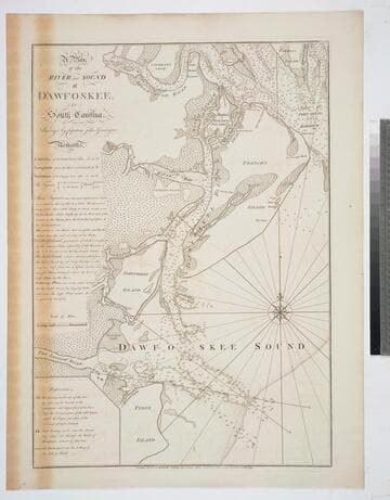
A Plan of the River and Sound of D'Awfoskee, in South Carolina. Survey'd by Captain John Gascoigne
Visual Materials
MS note: c 36. Prime meridian: London. Relief: no. Graphic Scale: Miles. Projection: Plane. Watermark: Crowned fleur-di-lis VI. Printing Process: Copper engraving. Verso Text: MS note: 349 10.
105:349 M
Image not available
A Chart of the Harbour of Halifax, in Nova Scotia; with Jebucto Bay and Cape Sambro. also the Islands, Ledges of Rocks, Shoals & Soundings
Visual Materials
Kashnor notes, "The first issue of the Morris chart. It is the first separate chart of Halifax Harbour." The publication date is 1775 but Kashnor dates the map at [1760]. Includes sailing directions. Kershaw gives appeared in information and notes this is the second state of Jefferys' map. Detailed sailing directions.. "Survey'd by Order of His Excellency Brigadier General Lawrence, Governour of the Province of Nova Scotia; By Charles Morris, Chief Surveyor, Published by Command of the Rgiht Honourable the Lords of Trade & Plantations, For the Benefit of the Trade and Navigation of Great Britain and its Colonies." "To the Right Honourable George Dunk Earl of Halifax, First Lord Commissioner, and to the rest of the Right Honourable and Honourable Commissioners for Trade and Plantations, This Chart is most humbly Inscribed By their most obliged & obedient humble Sert. Thos. Jefferys." "London Engraved by Thomas Jefferys, Geographer to the King." Relief: hachures. Graphic Scale: Miles. Projection: Plane. Watermark: Crowned fluer-di-lis VI. Printing Process: Copper engraving. References: Kershaw 821. Verso Text: Ms note: 20.
105:660 M
Image not available
Chart of the Harbour of Boston, with the Soundings, Sailing-Marks and Other Directions
Visual Materials
Kashnor notes, "From the indications, Ruins of Charlestown, this map must have been executed about 1776." RLIN record suggests ca. 1777 and give publisher information. This map may be a source map for 105:064M. Relief: hachures. Graphic Scale: Miles, nautical. Projection: Plane. Watermark: Crowned fleur-di-lis. Printing Process: Copper engraving. Verso Text: MS notes: 65 2.
105:065 M

Island of Cuba with part of the Bahama Banks & the Martyrs. By Thos. Jeffereys, Geographer to his Majesty
Visual Materials
Kashnor notes, "Includes an accurate map of the adjacent seas, with soundings." Prime meridian: London, Ferro. Relief: pictorial. Projection: Mercator. Watermark: Crowned fleur-di-lis VI. Printing Process: Copper engraving. Verso Text: MS notes: 378 Island of Cuba & Bahama Banks.
105:378 M