Visual Materials
A Chart of the Banks of Newfoundland, Drawn from a Great Number of Hydrographical Surveys [etc.]
You might also be interested in
Image not available
A Chart of the Banks of Newfoundland, Drawn from a Great Number of Hydrographical Surveys
Visual Materials
"[Drawn] chiefly from those of Chabert, Cook and Fleurieu, Connected and Ascertained by Astronomical Observations." Tracks voyages of Fleurieu, Chabert and Cook. A later issue of map 105:548 with extended western coverage. Note ships have been redrawn, astronomical chart redrawn. Prime meridian: London. Relief: no. Graphic Scale: Leagues. Projection: Mercator. Printing Process: Copper engraving. Verso Text: MS notes: 549 .
105:549 M
Image not available
General Chart of the Island of Newfoundland with the Rocks & Soundings
Visual Materials
"Drawn from Surveys taken by Order of the Right Honourable the Lords Commissioners of the Admiralty. By James Cook and Michael Lane Surveyors and Others." Appeared in information from RLIN record. Prime meridian: London. Relief: pictorial. Projection: Cylindrical. Watermark: Crowned fleur-di-lis VI. Printing Process: Copper engraving. Verso Text: MS note: 557.
105:557 M
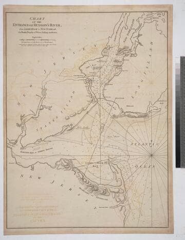
Chart of the Entrance of Hudson's River, from Sandy Hook to New York, with the Banks, Depths of Water, Sailing-marks &ca
Visual Materials
Kashnor notes, " The first issue of this chart. It was reissued in 1800 by Laurie & Whittle, but without date." Relief: hachures. Graphic Scale: Miles. Projection: Plane. Watermark: Crowned fleur-di-lis VI. Printing Process: Copper engraving. Verso Text: MS notes: 3 578.
105:578 M
Image not available
Chart of the Island of Fogo, On the Coast of Newfoundland
Visual Materials
"Surveyed by Order of Vice Admiral Campbell Governor of Newfoundland, &c. by Lieut Michael Lane, 1785.""Approved by the Chart Committee of the Admiralty." Fogo Island lies off the north coast of Newfoundland, north of Gander. Relief: no. Projection: Plane. Watermark: Edvieds(?) & Pine 1804 Crowned fleur-di-lis [good marks]. Printing Process: Copper engraving. Verso Text: MS note: 551 c24 9.
105:551 M
Image not available
New General Chart of the Atlantic or Western Ocean and Adjacent Seas, Including the Coasts of Europe and Africa From 60 Degrees North Latitude to the Equator, and also the Opposite Coast of America; Drawn and Regulated by the most accurate Astronomical Observations, and the Journals of the most experienced Navigators; in which also are particularly distinguished the Determination of the Longitude as given by the Marine Clocks of Mr. Ferdinand Berthoud, in the Voyage performed by order of the Government of France, in 1768 and 1769 in the Ship Isis, to the Azores, Madera, the Canaries, Cape-Verd Islands, St. Domingo, the Great Bank of Newfoundland, &ca. by Mr. de Fleurieu, an Officer in the French Navy, and Member of the Royal Marine Academy, &ca
Visual Materials
Kashnor notes, "Shows the American Coast from Hudson's Strait to the Mouth of the Amazon, and gives a particularly good chart of Nova Scotia and West Indies." Lengthy explanation of preparation of this chart lower right.. Prime meridian: London, Ferro. Relief: no. Projection: Mercator. Watermark: Crowned fleur-di-lis VI. Printing Process: Copper engraving. Verso Text: MS notes: 276 Chart of the Atlantic, Northern part -- Southern part 66.
093:276 M
Image not available
A Plan of Cape Fear River from the Bar to Brunswick
Visual Materials
Kashnor notes, "A very scarce chart. It was reissued in 1800 by Laurie & Whittle." MS note: c 38. Prime meridian: London. Relief: no. Graphic Scale: Miles. Projection: Plane. Watermark: Crowned fleur-di-lis VI. Printing Process: Copper engraving. Verso Text: MS notes: 347 7.
105:347 M