Visual Materials
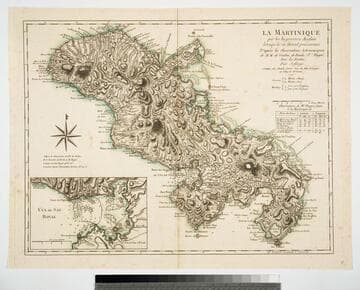
Martinico, Done from Actual Surveys and Observations, made by English Engineers whilst the Island was in their Possession. By Thomas Jefferys Geographer to the King. Lately improved by an officer

You might also be interested in

Martinico, Done from Actual Surveys and Observations, made by English Engineers whilst the Island was in their Possession, by Thomas Jefferys Geographer to the King
Visual Materials
Submap: Cul de Sac Royal. "VIII (upper right)" Prime meridian: Ferro. Relief: hachures. Graphic Scale: Leagues. Projection: Plane. Watermark: Crowned fleur-di-lis VI. Printing Process: Copper engraving. Other Features: Sub-maps. Verso Text: MS notes: 507 16.
105:507 M
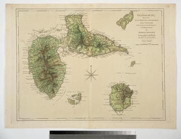
Guadaloupe, Done from Actual Surveys and Observations of the English, whilst the Island was in their possession with Improvements by Thomas Jefferys Geographer to the King
Visual Materials
See 093:772M for a later version of this map. Prime meridian: Ferro. Relief: hachures. Graphic Scale: Leagues. Projection: Cylindrical. Watermark: Crowned fleur-di-lis WF. Printing Process: Copper engraving. Verso Text: MS note: 771.
093:771

Guadaloupe, Done from Actual Surveys and Observations of the English, whilst the Island was in their possession with material Improvements added since the Conquest of 1794 to those made by Thomas Jefferys Geographer to the King
Visual Materials
See 093:771M for an earlier varsion of this map. Prime meridian: Ferro. Relief: hachures. Graphic Scale: Leagues. Projection: Cylindrical. Printing Process: Copper engraving. Verso Text: MS note: 772.
093:772 M
La Maretinique par les Ingenieurs Snglais lorsqui'ls en étoient possesseurs D'apres les Observations Astronomiques de M.M. de Verdun, de Borda & Pingré, Avec les Routes. Par Jefferys. A Paris, chez Charles Dien, Rue du Font St. Jacques au College de Mtre. Gervais. 1799
Visual Materials
Copy of Jeffery's map. Submap: Cul de Sac Royal. Table of astronomical observations.. Prime meridian: Ferro. Relief: hachures. Graphic Scale: Leagues. Projection: Cylindrical. Watermark: Chained maltese cross lettering. Printing Process: Copper engraving. Other Features: Sub-maps.
093:817 M

West India Islands: Martinico. ; Dominica
Visual Materials
Kashnor dates as [1814]. Submap: Cul de Sac Royal.. Prime meridian: Ferro, London. Relief: hachures. Graphic Scale: Leagues. Projection: Plane. Printing Process: Engraving. Other Features: Sub-maps. Verso Text: MS note: 506.
105:506a ; 105:506b

St. Lucia; Done from Surveys and Observations made by the English whilst in their Possession. by Thomad Jefferys Geographer to the King. Published by Laurie & Whittle, No. 53 Fleet Street London as the Act directs 12th May, 1794
Visual Materials
Submap: Plan of Carenage.. Prime meridian: London. Relief: hachures. Graphic Scale: Leagues. Projection: Cylindrical. Printing Process: Copper engraving. Other Features: Sub-maps.
093:830 M