Visual Materials
West India Islands: Martinico. ; Dominica

You might also be interested in

Martinico, Done from Actual Surveys and Observations, made by English Engineers whilst the Island was in their Possession, by Thomas Jefferys Geographer to the King
Visual Materials
Submap: Cul de Sac Royal. "VIII (upper right)" Prime meridian: Ferro. Relief: hachures. Graphic Scale: Leagues. Projection: Plane. Watermark: Crowned fleur-di-lis VI. Printing Process: Copper engraving. Other Features: Sub-maps. Verso Text: MS notes: 507 16.
105:507 M

Martinico, Done from Actual Surveys and Observations, made by English Engineers whilst the Island was in their Possession. By Thomas Jefferys Geographer to the King. Lately improved by an officer
Visual Materials
Submaps: Cul de Sac Royal; Cul de Sac Robert.. Prime meridian: Ferro. Relief: hachures. Graphic Scale: Leagues. Projection: Cylindrical. Printing Process: Copper engraving. Other Features: Sub-maps. Verso Text: MS note: 812.
093:812

West India Islands - St. Christophers. ; West India Islands - Nevis. ; West India Islands - St. Lucia
Visual Materials
Three maps on one sheet. Kashnor dates as [1816]. Prime meridian: London, Ferro. Relief: hachures. Graphic Scale: Miles, leagues. Projection: Plane. Printing Process: Copper engraving. Verso Text: MS notes: 777 West Indies Thomson.
105:777
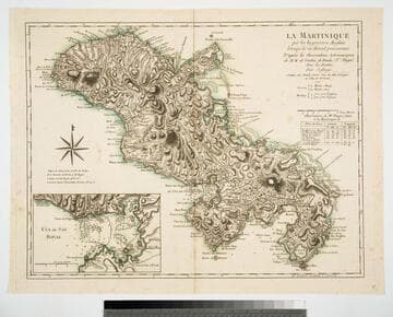
La Maretinique par les Ingenieurs Snglais lorsqui'ls en étoient possesseurs D'apres les Observations Astronomiques de M.M. de Verdun, de Borda & Pingré, Avec les Routes. Par Jefferys. A Paris, chez Charles Dien, Rue du Font St. Jacques au College de Mtre. Gervais. 1799
Visual Materials
Copy of Jeffery's map. Submap: Cul de Sac Royal. Table of astronomical observations.. Prime meridian: Ferro. Relief: hachures. Graphic Scale: Leagues. Projection: Cylindrical. Watermark: Chained maltese cross lettering. Printing Process: Copper engraving. Other Features: Sub-maps.
093:817 M

West India Islands And Adjacent Coasts of the United States, Mexico, Guatimala & Columbia
Visual Materials
Kashnor dates as ca. 1831. Submap: Island of Jamaica. "LXIV (upper left)" Prime meridian: GM. Relief: pictorial & hachures. Projection: Cylindrical. Printing Process: Copper engraving. Other Features: Sub-maps. Verso Text: MS notes: 974 West India Islands 64.
105:974 M

Carte Réduite de l'Isle de la Martinique Dresée au Dépost des Cartes et Journaux de la Marine
Visual Materials
Cartouche: flower draped. Submap: Plan du Cul de Sac Royal de la Martinique.. "No. 79 (upper right)" "Pour le Service des Vaisseaux du Roy. Par ordre de M. de Moras Ministre et Secretaire d'Etat ayant le Département de la Marine. Par M. Bellin Ingénieur de la Marine et du Dépost des Plans, Censeur Royal, de l'Academie de Marine, et las Société Royale de Londres. M DCC LVIII (1758)." Relief: pictorial. Graphic Scale: Leagues. Projection: Plane. Watermark: Seal & Lettering. Printing Process: Copper engraving. Other Features: Sub-mapsCartouche.
105:504 M