Visual Materials
West India Islands - St. Christophers. ; West India Islands - Nevis. ; West India Islands - St. Lucia

You might also be interested in

West India Islands: Martinico. ; Dominica
Visual Materials
Kashnor dates as [1814]. Submap: Cul de Sac Royal.. Prime meridian: Ferro, London. Relief: hachures. Graphic Scale: Leagues. Projection: Plane. Printing Process: Engraving. Other Features: Sub-maps. Verso Text: MS note: 506.
105:506a ; 105:506b

St. Vincent. Barbadoes. (Two maps on one sheet)
Visual Materials
Kashnor dates as 1816. See also 105:791 for an earlier dated version. Prime meridian: London, Ferro. Relief: hachures. Graphic Scale: Miles, leagues. Projection: Plane. Printing Process: Engraving. Verso Text: MS notes: 177 67 St. Vincent & Barbados.
105:177 M

Plan of the Attack against Fort Louis now Fort George, at Point a Pitre on the Island of Gaudaloupe: By a Squadron of his Majesty's Ships of War detached from Commodore Moore, & Commanded by Capt. Wm. Harman, on the 14 FRebruary 1759. Drawn on the Spot by Lieut. Col. Rycaut of the Marines
Visual Materials
Kashnor notes, "somewhat wormed." Submap: Plan of the Harbour of Point a Pitre on the Island of Guadaloupe. MS note: 777 (on backing). Relief: hachures. Graphic Scale: Yards. Projection: Plane. Printing Process: Copper engraving. Other Features: Sub-maps. Verso Text: MS note: 777 (on backing).
093:777 M

St. Christophers, or St. Kitts, surveyed By Anthony Ravell Esqr. Surveyor General of the Islands of St. Christophers, Nevis, & Montserrat. Engraved by Thomas Jefferys Geographer to the King
Visual Materials
See 093:827M for an earlier copy. Vignette: Nevis from shipboard Submap: Nevis, by Thomas Jefferys.. Prime meridian: London, Ferro. Relief: hachures. Graphic Scale: Miles, leagues. Projection: Cylindrical. Printing Process: Copper engraving. Other Features: VignettesSub-maps. Verso Text: MS notes: 828.
093:828 M
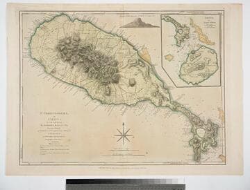
St. Christophers, or St. Kitts, surveyed By Anthony Ravell Esqr. Surveyor General of the Islands of St. Christophers, Nevis, & Montserrat. Engraved by Thomas Jefferys Geographer to the King
Visual Materials
See 093:828M for a later copy. Vignette: Nevis from shipboard Submap: Nevis, by Thomas Jefferys.. Prime meridian: London, Ferro. Relief: hachures. Graphic Scale: Miles, leagues. Projection: Cylindrical. Watermark: Crowned fluer-di-lid TW. Printing Process: Copper engraving. Other Features: VignettesSub-maps. Verso Text: MS notes: 827 43.
093:827 M
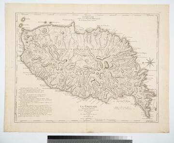
La Grenade Divisée par Paroisses Levée par ordre du Gouverneur Scott, Traduit de l'Anglais A Paris Chez le Rouge rue des Grands Augustins 1778 avec Privilege du Roi
Visual Materials
Kashnor notes, "The second issue, noting that D';Estaing attacked Port Royal in 1779." Prime meridian: Ferro, London. Relief: hachures. Graphic Scale: Leagues. Projection: Plane. Watermark: Chained maltese cross lettering. Printing Process: Copper engraving. Verso Text: MS note: 402.
105:402 M