Visual Materials
General Chart of the West-India Islands, With the adjacent Coasts of the Southern Continent; Including the Bay of Yucatan or Honduras. Composed from a great Variety of Surveys and Observations, Particularly those made by the Officers of the Spanish Navy. by John Purdy. Published by R. H. Laurie. Chartseller to the Admiralty, &c. &c. No. 53, Fleet Street, London. 14th June 1828. Additions &c. 1830

You might also be interested in

Map of the West India & Bahama Islands with the adjacent Coasts of Yucatan, Honduras, Caracas, &c
Visual Materials
Prime meridian: GM. Relief: hachures. Graphic Scale: Miles. Projection: Cylindrical. Printing Process: Copper engraving. Verso Text: MS note: 725.
093:725 M

Map of the West India & Bahama Islands with the adjacent Coasts of Yucatan, Honduras, Caracas, &c
Visual Materials
See also 105:957 for a later version. Prime meridian: GM. Relief: hachures. Graphic Scale: Miles. Projection: Cylindrical. Printing Process: Copper engraving. Verso Text: MS note: 956.
105:956 M

Map of the West India & Bahama Islands with the adjacent Coasts of Yucatan, Honduras, Caracas, &c
Visual Materials
See also 105:956 for an earlier version. Prime meridian: GM. Relief: hachures. Graphic Scale: Miles. Projection: Cylindrical. Printing Process: Copper engraving. Verso Text: MS note: 957.
105:957 M
Image not available
A General Chart of the West India Islands with the Adjacent Coasts of the Spanish Continent, by L. S. de la Rochette. MDCCXCVI (1796)
Visual Materials
Prime meridian: GM. Relief: no. Graphic Scale: Leagues. Projection: Cylindrical. Printing Process: Copper engraving. Verso Text: MS note: 952.
105:952 M
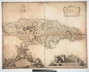
Ruatan or Rattan, Surveyed By Lieutenant Henry Barnsley, with Inprovements by Thomas Jefferys Geographer to the King. London: Published 12th. May 1794 by Laurie & Whittle, No. 53, Fleet Street
Visual Materials
Submaps: Old Providence and Sta. Catalina ; New Port Royal Harbour as Surveyed by Lieutenant Barnsley when the English took Possession in 1742.. Prime meridian: London. Relief: hachures. Graphic Scale: Miles, leagues. Projection: Cylindrical. Printing Process: Copper engraving. Other Features: Sub-maps. Verso Text: MS note: 823 47.
093:823 M
![New Granada [Columbia, Ecuador, Venezuala]](/_next/image?url=https%3A%2F%2Frail.huntington.org%2FIIIF3%2FImage%2F22APN4KU3RS9%2Ffull%2F%5E360%2C%2F0%2Fdefault.jpg&w=750&q=75)
New Granada [Columbia, Ecuador, Venezuala]
Visual Materials
Prime meridian: GM. Relief: hachures. Graphic Scale: Miles. Projection: Cylindrical. Printing Process: Copper engraving. Verso Text: Ms notes: 677/#93 677.
093:677