Visual Materials
Map of the West India & Bahama Islands with the adjacent Coasts of Yucatan, Honduras, Caracas, &c

You might also be interested in

Map of the West India & Bahama Islands with the adjacent Coasts of Yucatan, Honduras, Caracas, &c
Visual Materials
See also 105:957 for a later version. Prime meridian: GM. Relief: hachures. Graphic Scale: Miles. Projection: Cylindrical. Printing Process: Copper engraving. Verso Text: MS note: 956.
105:956 M

Map of the West India & Bahama Islands with the adjacent Coasts of Yucatan, Honduras, Caracas, &c
Visual Materials
See also 105:956 for an earlier version. Prime meridian: GM. Relief: hachures. Graphic Scale: Miles. Projection: Cylindrical. Printing Process: Copper engraving. Verso Text: MS note: 957.
105:957 M
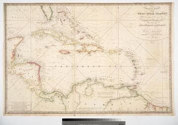
General Chart of the West-India Islands, With the adjacent Coasts of the Southern Continent; Including the Bay of Yucatan or Honduras. Composed from a great Variety of Surveys and Observations, Particularly those made by the Officers of the Spanish Navy. by John Purdy. Published by R. H. Laurie. Chartseller to the Admiralty, &c. &c. No. 53, Fleet Street, London. 14th June 1828. Additions &c. 1830
Visual Materials
Prime meridian: GM. Relief: hachures. Projection: Cylindrical. Printing Process: Copper engraving. Verso Text: MS note: 717.
093:717 M

Bermudas or Summer Islands; Chart of the Bahama Islands; Island of Cuba
Visual Materials
Three maps on one sheet. Prime meridian: GM. Relief: hachures. Graphic Scale: Miles. Projection: Cylindrical. Printing Process: Engraving. Verso Text: MS note: 180.
105:180 M
Image not available
A General Chart of the West India Islands with the Adjacent Coasts of the Spanish Continent, by L. S. de la Rochette. MDCCXCVI (1796)
Visual Materials
Prime meridian: GM. Relief: no. Graphic Scale: Leagues. Projection: Cylindrical. Printing Process: Copper engraving. Verso Text: MS note: 952.
105:952 M

West India Islands And Adjacent Coasts of the United States, Mexico, Guatimala & Columbia
Visual Materials
Kashnor dates as ca. 1831. Submap: Island of Jamaica. "LXIV (upper left)" Prime meridian: GM. Relief: pictorial & hachures. Projection: Cylindrical. Printing Process: Copper engraving. Other Features: Sub-maps. Verso Text: MS notes: 974 West India Islands 64.
105:974 M