Visual Materials
A General Chart of the West India Islands with the Adjacent Coasts of the Spanish Continent, by L. S. de la Rochette. MDCCXCVI (1796)
You might also be interested in

Map of the West India & Bahama Islands with the adjacent Coasts of Yucatan, Honduras, Caracas, &c
Visual Materials
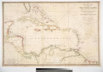
See also 105:957 for a later version. Prime meridian: GM. Relief: hachures. Graphic Scale: Miles. Projection: Cylindrical. Printing Process: Copper engraving. Verso Text: MS note: 956.
105:956 M

Map of the West India & Bahama Islands with the adjacent Coasts of Yucatan, Honduras, Caracas, &c
Visual Materials
See also 105:956 for an earlier version. Prime meridian: GM. Relief: hachures. Graphic Scale: Miles. Projection: Cylindrical. Printing Process: Copper engraving. Verso Text: MS note: 957.
105:957 M

Map of the West India & Bahama Islands with the adjacent Coasts of Yucatan, Honduras, Caracas, &c
Visual Materials
Prime meridian: GM. Relief: hachures. Graphic Scale: Miles. Projection: Cylindrical. Printing Process: Copper engraving. Verso Text: MS note: 725.
093:725 M

West India Islands And Adjacent Coasts of the United States, Mexico, Guatimala & Columbia
Visual Materials
Kashnor dates as ca. 1831. Submap: Island of Jamaica. "LXIV (upper left)" Prime meridian: GM. Relief: pictorial & hachures. Projection: Cylindrical. Printing Process: Copper engraving. Other Features: Sub-maps. Verso Text: MS notes: 974 West India Islands 64.
105:974 M
Image not available
A Chart of West Falkland Island
Visual Materials
Contains submap of other Falkland Islands. North is towards bottom of map. "from an Actual Survey by Lieut. Thos. Edgar of the Royal Navy, in the Years 1786 & 1787." "Engraved by T. Foot, Weston Place, Battle Bridge." Submap: Chart of Falkland Islands.. Prime meridian: GM. Relief: hachures. Graphic Scale: Leagues. Projection: Cylindrical. Printing Process: Copper engraving. Other Features: Sub-maps. Verso Text: MS notes: Jn. H. Coleman Falkland Island No. 3 915.
105:915 M
General Chart of the West-India Islands, With the adjacent Coasts of the Southern Continent; Including the Bay of Yucatan or Honduras. Composed from a great Variety of Surveys and Observations, Particularly those made by the Officers of the Spanish Navy. by John Purdy. Published by R. H. Laurie. Chartseller to the Admiralty, &c. &c. No. 53, Fleet Street, London. 14th June 1828. Additions &c. 1830
Visual Materials
Prime meridian: GM. Relief: hachures. Projection: Cylindrical. Printing Process: Copper engraving. Verso Text: MS note: 717.
093:717 M