Visual Materials
Chart of the West Indies and Spanish Dominions in North America. By A. Arrowsmith 1803

You might also be interested in
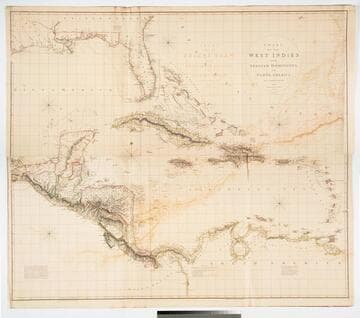
Chart of the West Indies and Spanish Dominions in North America. by A. Arrowsmith 1803. Hydrographer to H. R. H. the Prince of Wales. Additions to 1810 --1815
Visual Materials
Kashnor notes, "Amongst other interesting particulars, this map indicates the positions of the canals proposed to be cut by the Spaniards in 1528. The original issue of Arrowsmith's map, valuable for the detail regarding the coast of present-day Texas and the colonies of New Santander." Note from 105:948, another copy. Prime meridian: London. Relief: hachures. Projection: Cylindrical. Printing Process: Copper engraving. Verso Text: MS note: 715 XII XIII.
093:715 M

Chart of the West Indies and Spanish Dominions in North America. by A. Arrowsmith 1803. Hydrographer to H. R. H. the Prince of Wales. Additions to 1810
Visual Materials
See also 093:715M for a later copy. "Jones Smith & Co. sc. Beaufort Building Strand." Prime meridian: London. Relief: hachures. Projection: Cylindrical. Printing Process: Copper engraving. Verso Text: MS notes: 948 13 14.
105:948 M
Image not available
North America and the West Indies;
Visual Materials
Kashnor notes, "An exceedingly rare map, shoWing the country West of the Mississippi, the boundaries of Virginia, North and South Carolina, reaching to that river. The inset map of the country locates Old Forts EdWard, William Henry, Frederic, St. John, and Chamilles to the St. LaWrence, and Albany, Schenectadi, Forts Hunter and OsWego to Lake Ontario." Kashnor dates as ca. 1764. Submaps and treaty articles. See 093:532 for another copy. "a NeWMap, Wherein the British Empire and its limits, according to the difinitive (sic) Treaty of Peace in 1763, are accurately described, and the Dominions possessed by the Spaniards, the French and other European States; the Whole compiled from the NeWSurveys and Authentic Memoirs that have hitherto appeared. " Cartouche With Natives. Submaps: Particular Map of Baffin and Hudson's Bay; Map of the Country betWeen Montreal, Albany and OsWego. Paper sale tag, June 7, 1927 With MS note: #669.. Prime meridian: London, Ferro. Relief: pictorial. Graphic Scale: Miles, Leagues. Projection: Pseudocylindrical. Printing Process: Copper engraving. Other Features: CartoucheSub-mapsFigures .
105:669 M

A Map of the West-Indies or the Islands of America in the North Sea
Visual Materials
Kashnor notes, "The map also shows parts of Louisiana and South Carolina, and Central America. It is dedicated to William Paterson, the promoter of the Darien Colony." Kashnor dates as ca. 1720. View of Mexico City. Five submaps. See also 105:328M for another copy. View of Mexico City with building key; Submaps: St. Augustine; Vera Cruz; Havana; Darien; Cartagena.. "with the adjacent Countries; explaning [sic] what belongs to Spain, England, France, Holland &c. also the Trade Winds, and the several Tracts [sic] made by the Galeons [sic] and Flota from place to place. According to the Newest and most Exact Observations by Herman Moll Geographer." "To Wil. Paterson Esq; This map of the West-Indies &c. is most Humbly Dedicated by Herman Moll Geographer." Prime meridian: London. Relief: pictorial. Graphic Scale: Miles, leagues. Projection: Pseudocylindrical. Printing Process: Copper engraving. Other Features: VignettesSub-maps. Verso Text: MS notes: 958.
105:958 M
Image not available
Map of the United States of North America Drawn from a number of Critical Researches By A. Arrowsmith, Hydrographer to H.R.H. the Prince of Wales. No. 10 Soho Square
Visual Materials
Kashnor notes, "Takes in the territory to the Mississippi and part of Louisiana. It gives a good map of the Ohio territory and the Illinois country." see 105:628M and 105:629M for later versions of this map. Cartouche: Niagara Falls. . Prime meridian: GM. Relief: pictorial & hachures. Graphic Scale: Miles. Projection: Pseudocylindrical. Printing Process: Copper engraving. Other Features: Cartouche. Verso Text: IV V VI Vii MS note: Arrowsmith U.S.A. 627.
105:627 M
Image not available
Map of the United States of North America Drawn from a number of Critical Researches By A. Arrowsmith, Hydrographer to H.R.H. the Prince of Wales. No. 10 Soho Square
Visual Materials
Kashnor notes, "The finest map of the Western Territory at the time, and the detail regarding Ohio, Illinois, and Michigan Territory is of great value, and very accurate. Shows the old Indian boundaries of 1792, and the chain of forts from Fort Washington to Fort Wayne. Of all mapmakers Aaron Arrowsmith was the one who excelled as a geographer." See 105:627M for an earlier copy, 105:629M for a later version. Cartouche: Niagara Falls. . Prime meridian: GM. Relief: pictorial & hachures. Graphic Scale: Miles. Projection: Pseudocylindrical. Printing Process: Copper engraving. Other Features: Cartouche. Verso Text: IV V VI Vii MS note: Arrowsmith U.S.A. iv sheets 628.
105:628 M