Visual Materials
Chart of the West Indies and Spanish Dominions in North America. by A. Arrowsmith 1803. Hydrographer to H. R. H. the Prince of Wales. Additions to 1810 --1815

You might also be interested in
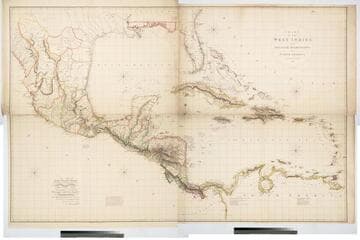
Chart of the West Indies and Spanish Dominions in North America. By A. Arrowsmith 1803
Visual Materials
Kashnor notes, "Amongst other interesting particulars, this map indicates the positions of the canals proposed to be cut by the Spaniards in 1528. The original issue of Arrowsmith's map, valuable for the detail regarding the coast of present-day Texas and the colonies of New Santander." " Jones Smith & Co. sc. Beaufort Build'gs Strand." "To Admiral John Willett Payne, A distinguished Native of the West Indies. Vice Admiral of the Coasts of Devonshire & Cornwall, Treasurer of Greenwich Hospital, Comptroller General of the Household of the Prince, &c., &c., &c. This chart is respectfully Dedicated by his most obedient Serv't A. Arrowsmith." Prime meridian: London. Relief: hachures. Projection: Cylindrical. Printing Process: Copper engraving. Verso Text: MS note: 795.
105:795 M

Chart of the West Indies and Spanish Dominions in North America. by A. Arrowsmith 1803. Hydrographer to H. R. H. the Prince of Wales. Additions to 1810
Visual Materials
See also 093:715M for a later copy. "Jones Smith & Co. sc. Beaufort Building Strand." Prime meridian: London. Relief: hachures. Projection: Cylindrical. Printing Process: Copper engraving. Verso Text: MS notes: 948 13 14.
105:948 M
Image not available
A Map Exhibiting all the New Discoveries in the Interior Part of North America, Inscribed by Permission To the Honorable Governor and Company of Adventurers of England Trading into Hudsons Bay In testimony to their liberal Communication To their most Obedient and very Humble Servant A. Arrowsmith, Hydrographer to H.R.H. the Prince of Wales. Puke Sc. No. 10 Soho Square, January 1st 1795, Additions to 1811, June 1814, 1818
Visual Materials
Kashnor notes, "The best issue of Aaron Arrowsmith's rare map. It is one of the masterpieces of American cartography. The information contained is most valuable, especially that which relates to the numbers and locations of the Indian Tribes of the Far West, Rupert's Land, and Oregon. It embodies the discoveries of Lewis and Clark as well as Vancouver, which makes the map the most important of the period, especially with regard to California, Oregon and the Rockies, in fact, it is impossible to state how valuable it is to the student of exploration of the Far West and Pacific Coast." See 105:235 for 1802 version. Prime meridian: London. Relief: hachures. Projection: Pseudocylindrical. Printing Process: Copper engraving. Verso Text: III MS note: 105/441.
105:441 M
Image not available
Hydrographical Chart of the World of Wright and Mercators Projection, with Tracts of the last Circumnavigators
Visual Materials
Kashnor notes, "Gives a map of the North-West Coast, and shows the tracks of Vancouver, Cook, and La Perouse." See 105:233M for another copy. Printed No. 1 pasted upper right corner.. Prime meridian: GM. Relief: pictorial. Graphic Scale: No. Projection: Mercator. Printing Process: Copper engraving. Verso Text: MS. note: 24.
093:024 M
Image not available
Map of the United States of North America Drawn from a number of Critical Researches By A. Arrowsmith, Hydrographer to H.R.H. the Prince of Wales. No. 10 Soho Square
Visual Materials
Kashnor notes, "Takes in the territory to the Mississippi and part of Louisiana. It gives a good map of the Ohio territory and the Illinois country." see 105:628M and 105:629M for later versions of this map. Cartouche: Niagara Falls. . Prime meridian: GM. Relief: pictorial & hachures. Graphic Scale: Miles. Projection: Pseudocylindrical. Printing Process: Copper engraving. Other Features: Cartouche. Verso Text: IV V VI Vii MS note: Arrowsmith U.S.A. 627.
105:627 M
Image not available
Map of Louisiana and of the River Mississipi by John Senex
Visual Materials
Kashnor notes, "The best of the early English maps, giving particulars of the West. The Mississippi is given with all its tributaries, the Red, Arkansas and Missouri Rivers, the last-named being shown with remarkable correctness, its course reaching to the north of the Rockies, where it is stated that the Spaniards ford the river to trade with the people to the North-West for "yellow iron." The map shows New Mexico, and locates Santa Fe." Kashnor dates as [1719]. New Orleans does not appear, same as on l'Isle map of same year. See 148964 for another copy, 093:429 for an apparently later copy. Cartouche: Around dedication. Prime meridian: London. Relief: pictorial. Graphic Scale: Leagues. Projection: Cylindrical. Watermark: Small fleur-di-lis. Printing Process: Copper engraving. Other Features: Cartouche. Verso Text: MS note: 558.
093:558 M