Visual Materials
Map of the United States of North America Drawn from a number of Critical Researches By A. Arrowsmith, Hydrographer to H.R.H. the Prince of Wales. No. 10 Soho Square
You might also be interested in
Image not available
Map of the United States of North America Drawn from a number of Critical Researches By A. Arrowsmith, Hydrographer to H.R.H. the Prince of Wales. No. 10 Soho Square
Visual Materials
Kashnor notes, "The finest map of the Western Territory at the time, and the detail regarding Ohio, Illinois, and Michigan Territory is of great value, and very accurate. Shows the old Indian boundaries of 1792, and the chain of forts from Fort Washington to Fort Wayne. Of all mapmakers Aaron Arrowsmith was the one who excelled as a geographer." See 105:627M for an earlier copy, 105:629M for a later version. Cartouche: Niagara Falls. . Prime meridian: GM. Relief: pictorial & hachures. Graphic Scale: Miles. Projection: Pseudocylindrical. Printing Process: Copper engraving. Other Features: Cartouche. Verso Text: IV V VI Vii MS note: Arrowsmith U.S.A. iv sheets 628.
105:628 M
Image not available
Map of the United States of North America Drawn from a number of Critical Researches By A. Arrowsmith, Hydrographer to H.R.H. the Prince of Wales. No. 10 Soho Square
Visual Materials
Kashnor notes, "Takes in the territory to the Mississippi and part of Louisiana. Shows Ohio, Indiana, and Illinois as States with recognised boundaries, and has an extra slip showing Lake of the Woods and Lake Winnipeg." Also a pasted addition showing the Mississippi delta. See also 105:627, 105:628 for earlier versions. Kashnor dates this copy as 1819. Cartouche: Niagara Falls. . Prime meridian: GM. Relief: pictorial & hachures. Graphic Scale: Miles. Projection: Pseudocylindrical. Printing Process: Copper engraving. Other Features: Cartouche. Verso Text: IV V VI Vii MS note: 629.
105:629 M
Image not available
A Map of the United States of North America drawn from a number of Critical Researches / by A. Arrowsmith, Geographer
Visual Materials
Kashnor notes, "Takes in the territory to the Mississippi and part of Louisiana. It gives a good map of the Ohio territory and Illinois Country." Cartouche: Falls of Niagara.. Prime meridian: GM. Relief: pictorial & hachures. Graphic Scale: Miles. Projection: Pseudocylindrical. Printing Process: Copper engraving. Other Features: Cartouche. Verso Text: MS note: 523.
093:523
Image not available
A Map Exhibiting all the New Discoveries in the Interior Part of North America, Inscribed by Permission To the Honorable Governor and Company of Adventurers of England Trading into Hudsons Bay In testimony to their liberal Communication To their most Obedient and very Humble Servant A. Arrowsmith, Hydrographer to H.R.H. the Prince of Wales. Puke Sc. No. 10 Soho Square, January 1st 1795, Additions to 1811, June 1814, 1818
Visual Materials
Kashnor notes, "The best issue of Aaron Arrowsmith's rare map. It is one of the masterpieces of American cartography. The information contained is most valuable, especially that which relates to the numbers and locations of the Indian Tribes of the Far West, Rupert's Land, and Oregon. It embodies the discoveries of Lewis and Clark as well as Vancouver, which makes the map the most important of the period, especially with regard to California, Oregon and the Rockies, in fact, it is impossible to state how valuable it is to the student of exploration of the Far West and Pacific Coast." See 105:235 for 1802 version. Prime meridian: London. Relief: hachures. Projection: Pseudocylindrical. Printing Process: Copper engraving. Verso Text: III MS note: 105/441.
105:441 M
Image not available
A Chart of the Banks of Newfoundland, Drawn from a Great Number of Hydrographical Surveys
Visual Materials
"[Drawn] chiefly from those of Chabert, Cook and Fleurieu, Connected and Ascertained by Astronomical Observations." Tracks voyages of Fleurieu, Chabert and Cook. A later issue of map 105:548 with extended western coverage. Note ships have been redrawn, astronomical chart redrawn. Prime meridian: London. Relief: no. Graphic Scale: Leagues. Projection: Mercator. Printing Process: Copper engraving. Verso Text: MS notes: 549 .
105:549 M
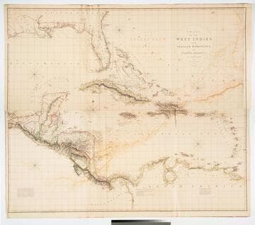
Chart of the West Indies and Spanish Dominions in North America. by A. Arrowsmith 1803. Hydrographer to H. R. H. the Prince of Wales. Additions to 1810 --1815
Visual Materials
Kashnor notes, "Amongst other interesting particulars, this map indicates the positions of the canals proposed to be cut by the Spaniards in 1528. The original issue of Arrowsmith's map, valuable for the detail regarding the coast of present-day Texas and the colonies of New Santander." Note from 105:948, another copy. Prime meridian: London. Relief: hachures. Projection: Cylindrical. Printing Process: Copper engraving. Verso Text: MS note: 715 XII XIII.
093:715 M