Visual Materials
A Map Exhibiting all the New Discoveries in the Interior Part of North America, Inscribed by Permission To the Honorable Governor and Company of Adventurers of England Trading into Hudsons Bay In testimony to their liberal Communication To their most Obedient and very Humble Servant A. Arrowsmith, Hydrographer to H.R.H. the Prince of Wales. Puke Sc. No. 10 Soho Square, January 1st 1795, Additions to 1811, June 1814, 1818
You might also be interested in
Image not available
Map of the United States of North America Drawn from a number of Critical Researches By A. Arrowsmith, Hydrographer to H.R.H. the Prince of Wales. No. 10 Soho Square
Visual Materials
Kashnor notes, "Takes in the territory to the Mississippi and part of Louisiana. It gives a good map of the Ohio territory and the Illinois country." see 105:628M and 105:629M for later versions of this map. Cartouche: Niagara Falls. . Prime meridian: GM. Relief: pictorial & hachures. Graphic Scale: Miles. Projection: Pseudocylindrical. Printing Process: Copper engraving. Other Features: Cartouche. Verso Text: IV V VI Vii MS note: Arrowsmith U.S.A. 627.
105:627 M
Image not available
Map of the United States of North America Drawn from a number of Critical Researches By A. Arrowsmith, Hydrographer to H.R.H. the Prince of Wales. No. 10 Soho Square
Visual Materials
Kashnor notes, "The finest map of the Western Territory at the time, and the detail regarding Ohio, Illinois, and Michigan Territory is of great value, and very accurate. Shows the old Indian boundaries of 1792, and the chain of forts from Fort Washington to Fort Wayne. Of all mapmakers Aaron Arrowsmith was the one who excelled as a geographer." See 105:627M for an earlier copy, 105:629M for a later version. Cartouche: Niagara Falls. . Prime meridian: GM. Relief: pictorial & hachures. Graphic Scale: Miles. Projection: Pseudocylindrical. Printing Process: Copper engraving. Other Features: Cartouche. Verso Text: IV V VI Vii MS note: Arrowsmith U.S.A. iv sheets 628.
105:628 M
Image not available
Map of the United States of North America Drawn from a number of Critical Researches By A. Arrowsmith, Hydrographer to H.R.H. the Prince of Wales. No. 10 Soho Square
Visual Materials
Kashnor notes, "Takes in the territory to the Mississippi and part of Louisiana. Shows Ohio, Indiana, and Illinois as States with recognised boundaries, and has an extra slip showing Lake of the Woods and Lake Winnipeg." Also a pasted addition showing the Mississippi delta. See also 105:627, 105:628 for earlier versions. Kashnor dates this copy as 1819. Cartouche: Niagara Falls. . Prime meridian: GM. Relief: pictorial & hachures. Graphic Scale: Miles. Projection: Pseudocylindrical. Printing Process: Copper engraving. Other Features: Cartouche. Verso Text: IV V VI Vii MS note: 629.
105:629 M
Image not available
A New Chart of the World on Wright's or Mercator's Projection in which are Exhibited All the Parts Hitherto Explored or Discovered with the Tracks of the British Circumnavigators Byron, Wallis, Carteret and Cook, &c. and the track of la Pérouse in the Pacific Ocean
Visual Materials
Kashnor notes, "A valuable map of the North-West Coast, showing the discoveries and tracks of La Perouse and Vancouver, 1793-95. It locates Drake's Harbour and Monterey in California, and the Columbia River is still called the Oregon." See 105:043 and 105:261 for this map as issued in 1794, 093:044 and 105:262 for an 1800 version. Minimum cartouche with compass rose on top. Published information moved to make room for reference to la Pérouse.. Prime meridian: London. Relief: pictorial. Graphic Scale: No. Projection: Mercator. Printing Process: Copper engraving. Other Features: Cartouche. Verso Text: MS note: 263 3.
105:263 M
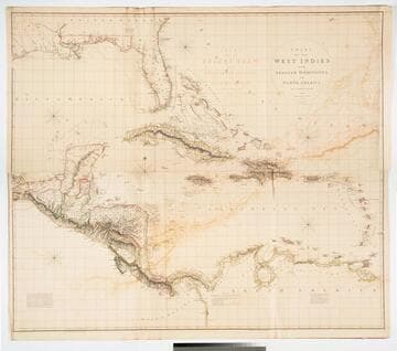
Chart of the West Indies and Spanish Dominions in North America. by A. Arrowsmith 1803. Hydrographer to H. R. H. the Prince of Wales. Additions to 1810 --1815
Visual Materials
Kashnor notes, "Amongst other interesting particulars, this map indicates the positions of the canals proposed to be cut by the Spaniards in 1528. The original issue of Arrowsmith's map, valuable for the detail regarding the coast of present-day Texas and the colonies of New Santander." Note from 105:948, another copy. Prime meridian: London. Relief: hachures. Projection: Cylindrical. Printing Process: Copper engraving. Verso Text: MS note: 715 XII XIII.
093:715 M
Image not available
A Chart of the South Seas by J. Seller, J. Colton, W. Fisher, J. Atkinson, & J. Thornton
Visual Materials
Kashnor notes, "Shows the west coast from "Fretum Anian" to the Straits of Magellan, New Guinea, and the Pacific Islands as far as they were then discovered. A very valuable and rare map of the west coast, showing California as an island, and locating P. Sir Francis Drake, Monte Rey, R. S. Barbara, ans P. S. Diego." McLaughlin identifies this as State 2 of this map. Kashnor dates as ca. 1680. Original map issued 1675 per McLaughlin, in Atlas maritimus. Map trimmed to neatline so is missing engraver attribution. Map partially copied from Jansson's earlier map, 105:249M. Cartouche includes figures of Native American, Chinese and Europeans. Part of cartouche directly copied from Jansson's 1650 map, 105:249M.. Relief: no. Graphic Scale: Leagues. Projection: Cylindrical. Printing Process: Copper engraving. Other Features: Cartouche. References: McLaughlin 58; Phillips 487; Wagner 410; Tooley 39; Leighly 66.. Verso Text: MS note: 225.
105:225 M