Visual Materials
Chart of the Isle of Trinidad From the Documents &ca. of the Spanish Vessels Employed in Surveying the Coasts of the Gulf of Mexico, 1793

You might also be interested in
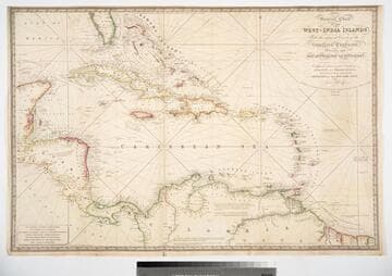
General Chart of the West-India Islands, With the adjacent Coasts of the Southern Continent; Including the Bay of Yucatan or Honduras. Composed from a great Variety of Surveys and Observations, Particularly those made by the Officers of the Spanish Navy. by John Purdy. Published by R. H. Laurie. Chartseller to the Admiralty, &c. &c. No. 53, Fleet Street, London. 14th June 1828. Additions &c. 1830
Visual Materials
Prime meridian: GM. Relief: hachures. Projection: Cylindrical. Printing Process: Copper engraving. Verso Text: MS note: 717.
093:717 M

New Chart of the Carribbean Isles called also The Windward & Leeward Islan ds from Porto Rico to Trinidad Improved from the latest Astronomical Observations & Surveys, By J. W. Norie, Hydrographer, &c.Engraved by J. Stephenson 1828
Visual Materials
Prime meridian: GM. Relief: hachures. Projection: Mercator. Printing Process: Copper engraving. Verso Text: MS note: 724 29.
093:724 M

Map of the West India & Bahama Islands with the adjacent Coasts of Yucatan, Honduras, Caracas, &c
Visual Materials
Prime meridian: GM. Relief: hachures. Graphic Scale: Miles. Projection: Cylindrical. Printing Process: Copper engraving. Verso Text: MS note: 725.
093:725 M

Plan of the Isle of Trinidad : from actual surveys made in the year 1797
Rare Books
Nicely colored with a table of population figures for 1797. Prime meridian: Port of Spain. Relief: hachures. Graphic Scale: Miles, Leagues. Projection: Cylindrical. Printing Process: Copper engraving. Verso Text: MS note: 841 [scratched over].
91026

General Chart of the West Indies and Gulf of Mexico, describing the Gulf and Windward Passages, Coasts of Florida, Louisiana and Mexico, Bay of Honduras and Mosquito Shore; Coast of the Spanish Main to the Mouth of the Orinoco. Drawn from the Surveys taken by Mr. Geo. Gaulo and others, the New Spanish Charts, &c. and adjusted for Recent Observations. J. Fodd Dessiou; Master of the Royal Navy. Approved by the Chart Committee of the Admiralty. London. Published by W. Faden, Geographer to His Majesty, and His Royal Highness the Prince of Wales. Charing Cross June 4th 1808. Written and engraved by John Roper
Visual Materials
See also 105:796M. One map on four sheets. Submaps: Chart of the Coast of Biruquete, Panama & Verugua; Chart of the Virgin Islands.. Prime meridian: GM. Relief: hachures. Projection: Cylindrical. Printing Process: Copper engraving. Other Features: Sub-maps. Verso Text: MS notes: 719 36 36* 36** 36***.
093:719 M

Spherical Chart of the Sea of The Antilles, and of the Coast of Terra Firma, from the Island of Trinidad to the Gulf of Honduras
Visual Materials
Submaps: Plan of the Mouth of the Gulf of Cariaco, and Anchorage of Cumana. Surveyed in 1793; Plan of the Anchorage of Truxillo.. "Constructed in the Hydrographical Department, by order of the Spanish Government, 1805." Prime meridian: GM, Cadiz. Relief: hachures. Projection: Cylindrical. Printing Process: Copper engraving. Other Features: Sub-maps. Verso Text: MS notes: 20 972.
105:972 M