Visual Materials
New Chart of the Carribbean Isles called also The Windward & Leeward Islan ds from Porto Rico to Trinidad Improved from the latest Astronomical Observations & Surveys, By J. W. Norie, Hydrographer, &c.Engraved by J. Stephenson 1828

You might also be interested in

Haiti, Hispaniola or St. Domingo; Porto Rico and Virgin Islands
Visual Materials
Two maps on one sheet. Kashnor dates as [1814]. Prime meridian: GM. Relief: hachures. Graphic Scale: Miles. Projection: Cylindrical. Printing Process: Copper engraving. Verso Text: MS note: 423.
105:423 M
Image not available
New Chart of the Coast of Brazil from Marankham to Rio Janerio, Drawn from the Latest Surveys, by J. W. Norie, Hydrographer. A New Edition 1828
Visual Materials
Cartouche: Sugar & Coffee leaves Submaps: Harbor of Rio Janerio; Bay of All Saints; Road of Pernambuco; Bay of St. Marcos; Island of Fernando Noronha; Entrance to St. Louis of Maranham. Vignettes: Six coastal vignettes.. Prime meridian: GM. Relief: hachures. Projection: Cylindrical. Printing Process: Copper engraving. Other Features: CartoucheVignettesSub-maps. Verso Text: MS notes: 650 32.
093:650 M
Image not available
Brazil, By J. Arrowsmith
Visual Materials
Prime meridian: GM. Relief: hachures. Graphic Scale: Miles, leagues. Projection: Pseudocylindrical. Printing Process: Copper engraving. Verso Text: MS note: 644.
093:644 M

Chart of the Atlantic or Western Ocean; from the Parallel of 3 Degrees to 59°, 30', North Latitude. Drawn from the Latest Observations of the English, French and Spanish Astronomers Wherein is delineated the Track of His Majesty's Fleet, Commanded by the late Viscount Nelson, K.B. Vice Adm. of the White, &c. &c. in Pursuit of the Combined Fleets of France and Spain 1805. A Course which in its consequences led to the Glorious Victory at Trafalgar. It is copied from His Lordship's original Manuscript, under His Lordship's special directions, & is now offered to the public as the slight tribute of an Individual to His Lordship's Fame & Memory. William Faden
Visual Materials
Shows track of H.M.S. Victory and of Warley East Indiaman. Later MS southbound track. Prime meridian: GM. Relief: no. Graphic Scale: Leagues. Projection: Mercator. Printing Process: Copper engraving. Verso Text: MS note: 713.
093:713 M
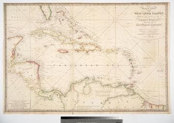
General Chart of the West-India Islands, With the adjacent Coasts of the Southern Continent; Including the Bay of Yucatan or Honduras. Composed from a great Variety of Surveys and Observations, Particularly those made by the Officers of the Spanish Navy. by John Purdy. Published by R. H. Laurie. Chartseller to the Admiralty, &c. &c. No. 53, Fleet Street, London. 14th June 1828. Additions &c. 1830
Visual Materials
Prime meridian: GM. Relief: hachures. Projection: Cylindrical. Printing Process: Copper engraving. Verso Text: MS note: 717.
093:717 M

Chart of the Isle of Trinidad From the Documents &ca. of the Spanish Vessels Employed in Surveying the Coasts of the Gulf of Mexico, 1793
Visual Materials
MS note: 840. Prime meridian: London. Relief: hachures. Projection: Cylindrical. Printing Process: Copper engraving. Verso Text: MS note: 840.
093:840 M