Rare Books
Plan of the Isle of Trinidad : from actual surveys made in the year 1797

You might also be interested in

Plan of the Isle of Trinidad, from actual Surveys made in the Year 1797
Visual Materials
Tables: The Island of Trinidad is Divided into the following Quarters; The Population of the I. of Trinidad 1797.. "Engraved by George Allen." Prime meridian: Port of Spain. Relief: hachures. Graphic Scale: Miles, leagues. Projection: Plane. Printing Process: Copper engraving.
105:807 M
Image not available
Map of the Eastern Townships of Lower Canada, Drawn principally from actual Survey for the British American Land Company, by A. Wells, Provincial Land Survr
Visual Materials
Kashnor notes, " Shows the enormous tracts of land held by the Company." [Each parcel hand colored.] Inset plan of Quebec City. Submap: Plan of Quebec [City]. Prime meridian: GM. Relief: hachures. Graphic Scale: Miles, leagues. Projection: Cylindrical. Printing Process: Engraving. Other Features: Sub-maps. Verso Text: MS notes: 2 sheets 350.
093:350 M
Image not available
New map of Brooklyn including Kings Co from the latest official surveys
Rare Books
A detailed map with neighborhoods named. Date table. Inset list of population of Kings County, by ward, according to the Census of 1880. Prime meridian: GM. Relief: hachures. Graphic Scale: Miles. Projection: Cylindrical. Printing Process: Lithography. Verso Text: MS note: 492537.
492537

Martinico, Done from Actual Surveys and Observations, made by English Engineers whilst the Island was in their Possession. By Thomas Jefferys Geographer to the King. Lately improved by an officer
Visual Materials
Submaps: Cul de Sac Royal; Cul de Sac Robert.. Prime meridian: Ferro. Relief: hachures. Graphic Scale: Leagues. Projection: Cylindrical. Printing Process: Copper engraving. Other Features: Sub-maps. Verso Text: MS note: 812.
093:812
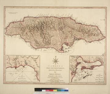
Jamaica from the latest surveys; Improved and Engraved by Thomas Jefferys Geographer to the King
Visual Materials
Two insert maps.See also 093:796M for a later version. Submap: Harbour of Bluefields; Harbour of Kingston aand Port Royal.. Prime meridian: London, Ferro. Relief: hachures. Graphic Scale: Miles, leagues. Projection: Cylindrical. Printing Process: Copper engraving. Other Features: Sub-maps. Verso Text: MS note: 795.
093:795 M

Guadaloupe, Done from Actual Surveys and Observations of the English, whilst the Island was in their possession with material Improvements added since the Conquest of 1794 to those made by Thomas Jefferys Geographer to the King
Visual Materials
See 093:771M for an earlier varsion of this map. Prime meridian: Ferro. Relief: hachures. Graphic Scale: Leagues. Projection: Cylindrical. Printing Process: Copper engraving. Verso Text: MS note: 772.
093:772 M