Visual Materials
Plan of the Isle of Trinidad, from actual Surveys made in the Year 1797

You might also be interested in

Plan of the Isle of Trinidad : from actual surveys made in the year 1797
Rare Books
Nicely colored with a table of population figures for 1797. Prime meridian: Port of Spain. Relief: hachures. Graphic Scale: Miles, Leagues. Projection: Cylindrical. Printing Process: Copper engraving. Verso Text: MS note: 841 [scratched over].
91026
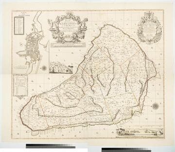
New and Exact Map of the Island of Barbadoes in America, According to an Actual and Accurate Survey made by William Mayo
Visual Materials
Kashnor notes, "Dedicated to James Bridges, Duke of Chandos. With inset plan of Bridgetown, prospect of Codrington College, and engraving representing the making of the survey; also statistics of population." See also 093:745M, another copy as engraved by John Senex 1722. Two elaborate cartouches. Submap - A Plan of Bridgetown. A view of Codrington College. View of surveyor with plane table, and native assistants with measuring wheel, surveying pole and chain. . Prime meridian: London. Relief: pictorial. Graphic Scale: Miles. Projection: Plane. Watermark: JW Whatman 1794. Printing Process: Copper engraving. Other Features: CartoucheSub-mapsVignettes. Verso Text: Ms notes: 174 4 sheets 23, 24, 25, 26..
105:174 M

Map of the Inhabited Part of Canada from the French Surveys With the Frontiers of NeW York and NeW England from the Large Survey by Claude Joseph Sauthier
Visual Materials
Kashnor notes, " With engraved locations of the 'Winter Quarters of the King's Army in Canada, 1776' and shoWing the old locations of the land grants around Lake Champlain and doWn to Lake George, made after the Old French War, a very rare map." see 105-305M for a variant copy. Elaborate cartouche of traders dealing With Indians for pelts. Includes "Winter quarters of the King's Army in Canada, 1776.". Relief: pictorial & hachures. Graphic Scale: Miles, statute, leagues, Canadian. Projection: Cylindrical. Watermark: J WHATMAN. Printing Process: Copper engraving. Other Features: Cartouche. References: McCorkle 777.19. Verso Text: MS note: 72.
105:072 M

Martinico, Done from Actual Surveys and Observations, made by English Engineers whilst the Island was in their Possession, by Thomas Jefferys Geographer to the King
Visual Materials
Submap: Cul de Sac Royal. "VIII (upper right)" Prime meridian: Ferro. Relief: hachures. Graphic Scale: Leagues. Projection: Plane. Watermark: Crowned fleur-di-lis VI. Printing Process: Copper engraving. Other Features: Sub-maps. Verso Text: MS notes: 507 16.
105:507 M
Image not available
A Chart of the Straits of Bellisle with part of the coast of Newfoundland and Labradore from actual surveys
Visual Materials
"Published by Permission of the Right Honourable the Lords Commissioners of the Admiralty and taken in 1766, by James Cook, afterwards Capt. Cook, the Celebrated Circumnavigator, and by Michael Lane in 1769." Submaps and sailing directions for the Straits of Bellisle. See 105:564M for a French copy of this map. Submaps: Bradhore Harbour; Red Bay; York, or Chateaux Bay; Cape Degrat; Croque Harbour; Old Ferrole Harbour.. Relief: hachures. Graphic Scale: Leagues. Projection: Plane. Printing Process: Copper engraving. Other Features: Sub-maps. Verso Text: MS note: 553.
105:553 M
Image not available
Chart of West Falkland Island, from an Actual Survey by Lieut. Thos. Edgar of the Royal Navy, in the Years 1786 & 1787
Visual Materials
Submap: Chart of Falkland Islands.. Prime meridian: GM. Relief: hachures. Graphic Scale: Leagues. Projection: Plane. Printing Process: Copper engraving. Other Features: Sub-maps. Verso Text: MS notes: 657 22.
093:657 M