Visual Materials
Spanish North America Southern Part
You might also be interested in
Image not available
A New and accurate Map of the Province of Virginia, in North America
Visual Materials
Kashnor dates as ca. 1750. Shows London, Maryland. Jolly gives appeared in information and later dating. RLIN record supplies cartographer. MS note: 105/819 (on backing). Prime meridian: London. Relief: pictorial. Projection: Cylindrical. Watermark: Two seals. Printing Process: Copper engraving. Other Features: Cartouche. References: Jolly UNIV-183; Phillips Maps p.983..
105:819 M
Image not available
North America
Visual Materials
Kashnor shows author as [N. Salmon, 1753] and notes engraved by J. Gibson. RLIN record suggests printing date as late as 1780. MS note: 342 (on backing). Prime meridian: London. Relief: pictorial. Projection: Pseudocylindrical. Watermark: VI. Printing Process: Copper engraving.
105:342 S
Image not available
United States of North America, with the British & Spanish Territories and those of Spain, according to the Treaty of 1784
Visual Materials
Kashnor notes, "Similar to Faden's map of "The British Colonies in North America," with the addition of colored contours indicative of the British, Spanish, French and American frontiers." "Engraved by Wm. Faden." See 105:148 for an earlier copy, 093:544, 093:545 for later copies. RLIN record adds appeared in information. Cartouche of Caribbean traders.. Prime meridian: London. Relief: pictorial. Projection: Pseudocylindrical. Printing Process: Copper engraving. Other Features: Cartouche. Verso Text: MS notes : 654 Faden U.S.A. 1793.
105:654 M
Image not available
Map of North America With the European Settlements & whatever else is remarkable in the West Indies, from the latest and best Observations
Visual Materials
Kashnor notes, "Copied from an old map, and still showing California as an island and La Hontan's River Longue. Locates Po. Sir Francis Drake, M. Nevada, and Mt. St. Martin." RLIN record gives printing location and appeared in information. Kashnor dates ca. 1740, RLIN record suggests [1745?], McLaughlin lists [1745]. Prime meridian: London. Relief: pictorial. Projection: Conic. Watermark: Fleur-di-lis. Printing Process: Copper engraving. Other Features: Cartouche. References: McLaughlin 228; Wheat 124,202; Tooley 97; Leighly 173 (Plate XXIII). Verso Text: MS notes: 105 #241.
105:241 S
Image not available
Map of that part of America which was the Principal Seat of War. in 1756
Visual Materials
Kashnor notes, "Nova Scotia to Massachusetts, and westward to Lake Ontario and the St. Lawrence." Kashnor dates as ca. 1760. RLIN record suggests printing date of 1757. MS note: 661 (on backing). Prime meridian: London. Relief: pictorial. Graphic Scale: Miles, leagues. Projection: Pseudocylindrical. Printing Process: Copper engraving.
105:661 S
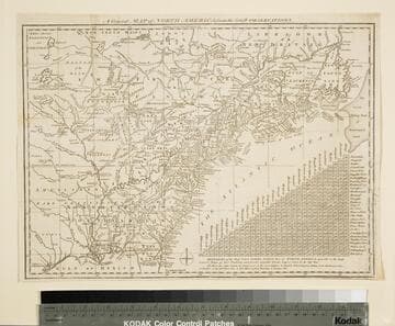
General Map of North America from the Latest Observations
Visual Materials
Kashnor gives date as [1776] RLIN record suggests 1778. Map includes distance chart between 29 American and Canadian cities. Bounds of Hudsons Bay [Co.] shown by Treaty of Utrecht. MS note: 102 (on backing). Prime meridian: London. Relief: pictorial. Projection: Mercator. Printing Process: Copper engraving. Verso Text: MS note: 1776.
105:102 S