Visual Materials
Map of that part of America which was the Principal Seat of War. in 1756
You might also be interested in
Image not available
North America
Visual Materials
Kashnor shows author as [N. Salmon, 1753] and notes engraved by J. Gibson. RLIN record suggests printing date as late as 1780. MS note: 342 (on backing). Prime meridian: London. Relief: pictorial. Projection: Pseudocylindrical. Watermark: VI. Printing Process: Copper engraving.
105:342 S
Image not available
A map of that part of America which was the principal seat of war in 1756
Rare Books
For a similar, possibly later, version see RB 105:661. MS notes: Cat 4/643 Maps N.A. 2. 41120. Prime meridian: London. Relief: no. Projection: Cylindrical. Printing Process: Copper engraving.
41120
Image not available
Accurate Map of Louisiana, and the Territory in Dispute between the English & French
Visual Materials
Kashnor notes, "Includes parts of Virginia, North and South Carolina, Georgia and Florida." Kashnor dates as ca. 1755. RLIN record suggests 1761. RLIN record covers a photocopy but is included to add data of appeared in information. MS note: 421 (on backing). Prime meridian: London. Relief: pictorial. Graphic Scale: Miles. Projection: Pseudocylindrical. Printing Process: Copper engraving. Verso Text: MS note: 421 (on backing).
093:421 S

A new and accurate map of the present seat of war in North America, from a late survey
Visual Materials
Kashnor notes, "A scarce map, issued during the early part of the Revolution." Kashnor dates c.1776. RLIN record places publication in London and appearance in Universal Magazine. MS note: 107 (on backing). Prime meridian: Ferro. Relief: pictorial. Graphic Scale: Miles. Projection: Cylindrical. Watermark: Two seals. Printing Process: Copper engraving.
105:107 S

Province of Canada, by James Wyld, Geographer to the Queen and HRH Prince Albert
Visual Materials
Kashnor notes, "A fine map, with much detail. It includes New Brunswick, part of Nova Scotia, and the neighboring States of Maine, with the new boundaries, New York, New England, down to Connecticut and Vermont." Kashnor dates as c. 1842. RLIN record suggests [1852?] Prime meridian: GM. Relief: hachures. Projection: Pseudocylindrical. Printing Process: Engraving.
093:136 M
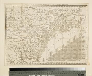
General Map of North America from the Latest Observations
Visual Materials
Kashnor gives date as [1776] RLIN record suggests 1778. Map includes distance chart between 29 American and Canadian cities. Bounds of Hudsons Bay [Co.] shown by Treaty of Utrecht. MS note: 102 (on backing). Prime meridian: London. Relief: pictorial. Projection: Mercator. Printing Process: Copper engraving. Verso Text: MS note: 1776.
105:102 S