Visual Materials
Map of North America With the European Settlements & whatever else is remarkable in the West Indies, from the latest and best Observations
You might also be interested in
Image not available
A Map of South America With all the European Settlements & whatever else is remarkable from the latest & best Observations
Visual Materials
Kashnor dates as ca. 1770. RLIN record indicates this may be as early as 1745. Cartouche: frilled. Stain upper right from material stuck to verso.. Prime meridian: London. Relief: pictorial. Projection: Azimuthal. Watermark: Crowned fleur-di-lis VI. Printing Process: Copper engraving. Other Features: Cartouche. Verso Text: MS note: 849.
105:849 S
Image not available
America : drawn from the latest and best observations ; describing all the European settlements, &c. / by R. Bennett Engraver
Visual Materials
Kashnor notes, "California appears as an island, with the Straits of Annian, at which the coastline terminates at its northern extremity." Kashnor dates as 177-. McLaughlin notes publication date as 1759, issued in Grand magazine of universal intellegence, Vol, 2, January 1759, and place as [London]. This map trimmed to neatline, loosing reference information regarding publication, "Engraved for the Grand Magazine. Printed for R. Griffiths in Paternoster Row 1759." MS note: 196 (on backing). Prime meridian: London. Relief: pictorial. Projection: Pseudocylindrical. Watermark: Crowned Britannia seal Crowned initials. Printing Process: Copper engraving. References: McLaughlin 239; Jolly 130.
105:196 S
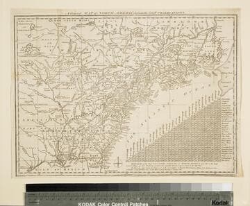
General Map of North America from the Latest Observations
Visual Materials
Kashnor gives date as [1776] RLIN record suggests 1778. Map includes distance chart between 29 American and Canadian cities. Bounds of Hudsons Bay [Co.] shown by Treaty of Utrecht. MS note: 102 (on backing). Prime meridian: London. Relief: pictorial. Projection: Mercator. Printing Process: Copper engraving. Verso Text: MS note: 1776.
105:102 S
Image not available
A Map of the British and French Settlements in North America
Visual Materials
Kashnor notes, "shewing the French encroachment and forts, and with an account of the English claims to the territories in dispute." Kashnor dates as ca. 1756. RLIN record suggests 1750-59. Cartouche includes Lodge's name. Detailed history of various English colonies. MS note: 622 (on backing).. Prime meridian: London. Relief: pictorial. Projection: Mercator. Printing Process: Copper engraving. Other Features: Cartouche. Verso Text: MS notes: 63 G47.
105:662 S
Image not available
North America
Visual Materials
Kashnor shows author as [N. Salmon, 1753] and notes engraved by J. Gibson. RLIN record suggests printing date as late as 1780. MS note: 342 (on backing). Prime meridian: London. Relief: pictorial. Projection: Pseudocylindrical. Watermark: VI. Printing Process: Copper engraving.
105:342 S
Image not available
Totius Americae Septentrionalis et Meridionalis : novissima repraesentatio quam ex singulis recentium geographorum tabulis collectam luci publicae accomodavit / Johannes Baptista Homann
Visual Materials
Kashnor notes, "Shows California as an island, with 'Fretum Anian' immediately at its northern extremity." Kashnor dates as ca. 1720. McLaughlin dates as 1710 and provides appeared in information. Also information that title cartouche is copied from DeFer's 1699 map and upper cartouche is copied from DeLisle's map of Canada of 1703. RLIN record dates as late as 1732. Two cartouches, colored. Prime meridian: Tenerife. Relief: pictorial. Projection: Azimuthal. Watermark: Elephant. Printing Process: Copper engraving. References: McLaughlin 175; Phillips 539; Tooley 79 9Plate 57); Leighly 133; Portinaro (Plate CIX). Verso Text: MS note: 298.
105:298 M