Visual Materials
America : drawn from the latest and best observations ; describing all the European settlements, &c. / by R. Bennett Engraver
You might also be interested in
Image not available
A Map of South America With all the European Settlements & whatever else is remarkable from the latest & best Observations
Visual Materials
Kashnor dates as ca. 1770. RLIN record indicates this may be as early as 1745. Cartouche: frilled. Stain upper right from material stuck to verso.. Prime meridian: London. Relief: pictorial. Projection: Azimuthal. Watermark: Crowned fleur-di-lis VI. Printing Process: Copper engraving. Other Features: Cartouche. Verso Text: MS note: 849.
105:849 S
Image not available
Map of North America With the European Settlements & whatever else is remarkable in the West Indies, from the latest and best Observations
Visual Materials
Kashnor notes, "Copied from an old map, and still showing California as an island and La Hontan's River Longue. Locates Po. Sir Francis Drake, M. Nevada, and Mt. St. Martin." RLIN record gives printing location and appeared in information. Kashnor dates ca. 1740, RLIN record suggests [1745?], McLaughlin lists [1745]. Prime meridian: London. Relief: pictorial. Projection: Conic. Watermark: Fleur-di-lis. Printing Process: Copper engraving. Other Features: Cartouche. References: McLaughlin 228; Wheat 124,202; Tooley 97; Leighly 173 (Plate XXIII). Verso Text: MS notes: 105 #241.
105:241 S
Image not available
North America Drawn from the latest and best Authorities
Visual Materials
Kashnor notes, "Shows the California coast north the Juan de Fuca Strait, with the entrance of Aguilar in the locality of the Columbia River and as the outlet of the River of the West." Prime meridian: London. Relief: pictorial. Projection: Polar, dual hemisphere. Printing Process: Copper engraving. Verso Text: MS note: 278.
105:278 S
Image not available
A New Map of South America, Drawn from the latest Discoveries
Visual Materials
Kashnor dates as ca. 1800. MS note: 852 (on backing). Prime meridian: London. Relief: pictorial. Projection: Pseudocylindrical. Printing Process: Copper engraving.
105:852 S
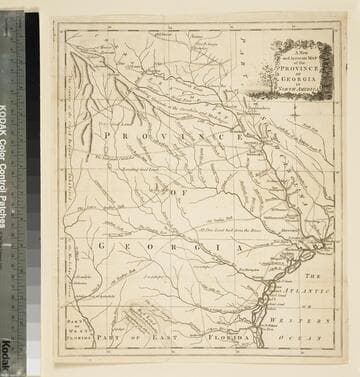
A new and accurate map of the province of Georgia in North America
Visual Materials
Kashnor notes," An old map published about 1775, shewing the roads and Indian paths." Kashnor dates c.1775. Duplicate map to 093:094S, 093:391. RLIN record notes date as [1779?] and place of publication as [London?] and as appearing in The Universal Magazine of 1779. MS note: 103 (on backing). Prime meridian: [Ferro]. Relief: pictorial. Projection: Cylindrical. Watermark: Crowned circular seal. Printing Process: Copper engraving.
105:103 S
Image not available
North America Drawn from the latest and best Authorities
Visual Materials
Kashnor notes, "Gives an interesting view of the Western Territory, as then known, showing the supposed locations of the Indian nations, the 'Mountain of Bright Stones,'and the Mississippi as far as the 46th deg., with note, 'Thus far the Mississippi has been ascended.' Shows the Columbia as part of the River of the West, which flows from Pike's Lake." "T. Kitchin del." "Engraved by G.Terry." Prime meridian: London. Relief: pictorial. Projection: Azimuthal. Printing Process: Copper engraving. Verso Text: MS notes: 712 L..
105:712 M