Visual Materials
A New and accurate Map of the Province of Virginia, in North America
You might also be interested in
Image not available
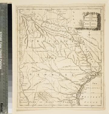
A new and accurate map of the province of Georgia in North America
Visual Materials
Kashnor notes, "Shows the old trading paths and the Hunting Grounds of the Cherokees." Kashnor dates c.1776. RLIN record notes date as [1779?] and place of publication as [London?] and as appearing in The Universal Magazine of 1779. See 093:391 and 105:103 for additional copies. MS note: 391 (on backing). Prime meridian: [Ferro]. Relief: pictorial. Projection: Cylindrical. Watermark: Crowned circular seal. Printing Process: Copper engraving. Other Features: Cartouche. Verso Text: MS note: 391 (on backing).
093:391 M

A new and accurate map of the province of Georgia in North America
Visual Materials
Kashnor notes, "Shows the old trading paths and the Hunting Grounds of the Cherokees." Kashnor dates c.1776. RLIN record notes date as [1779?] and place of publication as [London?] and as appearing in The Universal Magazine of 1779. See 093:391 and 105:103 for additional copies. MS note: 94 (on backing). Prime meridian: [Ferro]. Relief: pictorial. Projection: Cylindrical. Watermark: Crowned circular seal. Printing Process: Copper engraving. Other Features: Cartouche. Verso Text: MS note: 32 94(on backing).
093:094 S
Image not available
An accurate map of the English Colonies in North America bordering on the River Ohio
Visual Materials
MS notes: 619 Universal Magazine Dec 1754 p241 (on backing). Prime meridian: Ferro. Relief: pictorial. Projection: Cylindrical. Printing Process: Copper engraving. References: Jolly Brit Per. Univ-41.
105:619 S

New and Accurate Map of the Province of South Carolina in North America
Visual Materials
Appears to be from same source as 093:094S. RLIN record gives dates and location of publication with question marks. MS note: 77 (on backing). Prime meridian: London. Relief: pictorial. Graphic Scale: Miles. Projection: Cylindrical. Watermark: Intricate seal. Printing Process: Copper engraving.
105:077 S

A new and accurate map of the present seat of war in North America, from a late survey
Visual Materials
Kashnor notes, "A scarce map, issued during the early part of the Revolution." Kashnor dates c.1776. RLIN record places publication in London and appearance in Universal Magazine. MS note: 107 (on backing). Prime meridian: Ferro. Relief: pictorial. Graphic Scale: Miles. Projection: Cylindrical. Watermark: Two seals. Printing Process: Copper engraving.
105:107 S
A new and accurate map of the province of Georgia in North America
Visual Materials
Kashnor notes," An old map published about 1775, shewing the roads and Indian paths." Kashnor dates c.1775. Duplicate map to 093:094S, 093:391. RLIN record notes date as [1779?] and place of publication as [London?] and as appearing in The Universal Magazine of 1779. MS note: 103 (on backing). Prime meridian: [Ferro]. Relief: pictorial. Projection: Cylindrical. Watermark: Crowned circular seal. Printing Process: Copper engraving.
105:103 S