Visual Materials
New and Accurate Map of the Province of South Carolina in North America

You might also be interested in
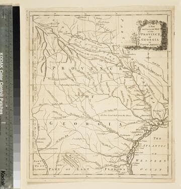
A new and accurate map of the province of Georgia in North America
Visual Materials
Kashnor notes," An old map published about 1775, shewing the roads and Indian paths." Kashnor dates c.1775. Duplicate map to 093:094S, 093:391. RLIN record notes date as [1779?] and place of publication as [London?] and as appearing in The Universal Magazine of 1779. MS note: 103 (on backing). Prime meridian: [Ferro]. Relief: pictorial. Projection: Cylindrical. Watermark: Crowned circular seal. Printing Process: Copper engraving.
105:103 S

A new and accurate map of the province of Georgia in North America
Visual Materials
Kashnor notes, "Shows the old trading paths and the Hunting Grounds of the Cherokees." Kashnor dates c.1776. RLIN record notes date as [1779?] and place of publication as [London?] and as appearing in The Universal Magazine of 1779. See 093:391 and 105:103 for additional copies. MS note: 94 (on backing). Prime meridian: [Ferro]. Relief: pictorial. Projection: Cylindrical. Watermark: Crowned circular seal. Printing Process: Copper engraving. Other Features: Cartouche. Verso Text: MS note: 32 94(on backing).
093:094 S
Image not available
A New and accurate Map of the Province of Virginia, in North America
Visual Materials
Kashnor dates as ca. 1750. Shows London, Maryland. Jolly gives appeared in information and later dating. RLIN record supplies cartographer. MS note: 105/819 (on backing). Prime meridian: London. Relief: pictorial. Projection: Cylindrical. Watermark: Two seals. Printing Process: Copper engraving. Other Features: Cartouche. References: Jolly UNIV-183; Phillips Maps p.983..
105:819 M
Image not available
A new and accurate map of the province of Georgia in North America
Visual Materials
Kashnor notes, "Shows the old trading paths and the Hunting Grounds of the Cherokees." Kashnor dates c.1776. RLIN record notes date as [1779?] and place of publication as [London?] and as appearing in The Universal Magazine of 1779. See 093:391 and 105:103 for additional copies. MS note: 391 (on backing). Prime meridian: [Ferro]. Relief: pictorial. Projection: Cylindrical. Watermark: Crowned circular seal. Printing Process: Copper engraving. Other Features: Cartouche. Verso Text: MS note: 391 (on backing).
093:391 M
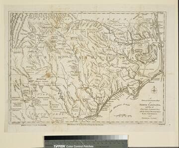
New and Accurate Map of North Carolina, and Part of South Carolina, with the Field of Battle between Earl Cornwallis and General Gates
Visual Materials
Duplicate of 093:074S. This copy stamped "Owens College Library, Manchester." Prime meridian: London. Relief: pictorial. Graphic Scale: Miles. Projection: Cylindrical. Watermark: Crowned oval. Printing Process: Copper engraving. Verso Text: MS note: 76 (on backing).
105:076 S

An accurate map of New Hampshire in New England, from a late survey
Visual Materials
Kashnor dates as ca. 1776. Maine is shown as part of New Hampshire. RLIN record gives place of publication, date, and appeared in information as Universal magazine of knowledge and pleasure, March, 1781. MS note: 112 (on backing). Prime meridian: London. Relief: pictorial. Projection: Cylindrical. Watermark: Seal. Printing Process: Copper engraving. References: McCorkle N781.1.
105:112 S