Visual Materials
Plan of the Island of St. Vincent laid down by Actual Survey under the Direction of The Honourable the Commissioners for the Sale of Lands in the Ceded Islands by John Byres Chief Surveyor 1776. J. Bayly Sculp. London

You might also be interested in

Plan of the Island of Tobago, laid down by actual survey under the Direction of the Honorable the Commissioners for the Sale of Lands in the Ceded Island by John Byres Chief Surveyor 1776. I. Bayley Sculp London Republished 14 July 1794, by Robert Wilkinson No. 58 Cornhill
Visual Materials
Shows lands set aside by the Crown for "Poor Settlers." Prime meridian: London, Ferro. Relief: hachures. Graphic Scale: Miles, chains. Projection: Cylindrical. Printing Process: Copper engraving. Verso Text: MS notes: 839 43.
093:839 M

Plan of the Island of Dominica Laid down by Actual Survey under the Direction of the Honorable the Commissioners for the Sale of Lands in the Ceded Island by John Byers Chief Surveyor 1776. J Bayly Sculp London
Visual Materials
Kashnor notes, "Dedicated to Thomas Shirley, Governor of Dominica, William Stuart, Lieutenant Governor, &c. An exceedingly fine map, very fully detailed, showing the lots intended for sale, with their respective numbers." Prime meridian: London. Relief: hachures. Graphic Scale: Miles. Projection: Plane. Watermark: J Whatman . Printing Process: Copper engraving. Verso Text: MS notes: 390 13 14 15.
105:390 M
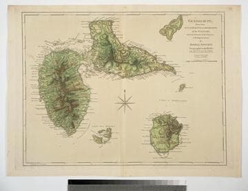
Guadaloupe, Done from Actual Surveys and Observations of the English, whilst the Island was in their possession with Improvements by Thomas Jefferys Geographer to the King
Visual Materials
See 093:772M for a later version of this map. Prime meridian: Ferro. Relief: hachures. Graphic Scale: Leagues. Projection: Cylindrical. Watermark: Crowned fleur-di-lis WF. Printing Process: Copper engraving. Verso Text: MS note: 771.
093:771
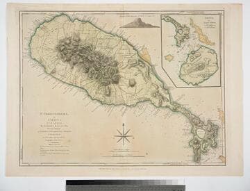
St. Christophers, or St. Kitts, surveyed By Anthony Ravell Esqr. Surveyor General of the Islands of St. Christophers, Nevis, & Montserrat. Engraved by Thomas Jefferys Geographer to the King
Visual Materials
See 093:828M for a later copy. Vignette: Nevis from shipboard Submap: Nevis, by Thomas Jefferys.. Prime meridian: London, Ferro. Relief: hachures. Graphic Scale: Miles, leagues. Projection: Cylindrical. Watermark: Crowned fluer-di-lid TW. Printing Process: Copper engraving. Other Features: VignettesSub-maps. Verso Text: MS notes: 827 43.
093:827 M
Image not available
Island and Colony of Cayenne subject to the French, on the Continent of South America. By Thomas Jefferys, Geographer to his Royal Highness the Prince of Wales
Visual Materials
Cartouche: leaved. MS note: 660. Prime meridian: Ferro. Relief: hachures. Graphic Scale: Miles, leagues. Projection: Cylindrical. Watermark: Crowned fleur-di-lis voer LVG IV. Printing Process: Copper engraving. Other Features: Cartouche. Verso Text: MS notes: 660 57.
093:660 S

Map of the Isle of Cuba, with the Bahama Islands, Gulf of Florida, and Windward Passage: Drawn from English and Spanish Surveys. Engraved by Thomas Jefferys, Geographer to His Majesty
Visual Materials
Prime meridian: London, Ferro. Relief: pictorial. Graphic Scale: Miles, leagues. Projection: Cylindrical. Watermark: Fleur-di-lis on coat of arms. Printing Process: Copper engraving.
093:754 S