Visual Materials
Plan of the Island of Tobago, laid down by actual survey under the Direction of the Honorable the Commissioners for the Sale of Lands in the Ceded Island by John Byres Chief Surveyor 1776. I. Bayley Sculp London Republished 14 July 1794, by Robert Wilkinson No. 58 Cornhill

You might also be interested in

Plan of the Island of St. Vincent laid down by Actual Survey under the Direction of The Honourable the Commissioners for the Sale of Lands in the Ceded Islands by John Byres Chief Surveyor 1776. J. Bayly Sculp. London
Visual Materials
Prime meridian: Ferro, London. Relief: hachures. Graphic Scale: Miles, chains . Projection: Cylindrical. Watermark: . Printing Process: Copper engraving. Verso Text: MS note: 833.
093:833
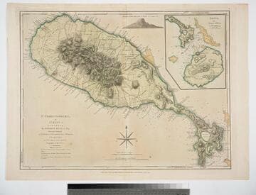
St. Christophers, or St. Kitts, surveyed By Anthony Ravell Esqr. Surveyor General of the Islands of St. Christophers, Nevis, & Montserrat. Engraved by Thomas Jefferys Geographer to the King
Visual Materials
See 093:828M for a later copy. Vignette: Nevis from shipboard Submap: Nevis, by Thomas Jefferys.. Prime meridian: London, Ferro. Relief: hachures. Graphic Scale: Miles, leagues. Projection: Cylindrical. Watermark: Crowned fluer-di-lid TW. Printing Process: Copper engraving. Other Features: VignettesSub-maps. Verso Text: MS notes: 827 43.
093:827 M

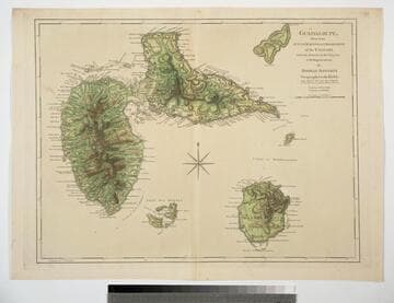
Guadaloupe, Done from Actual Surveys and Observations of the English, whilst the Island was in their possession with material Improvements added since the Conquest of 1794 to those made by Thomas Jefferys Geographer to the King
Visual Materials
See 093:771M for an earlier varsion of this map. Prime meridian: Ferro. Relief: hachures. Graphic Scale: Leagues. Projection: Cylindrical. Printing Process: Copper engraving. Verso Text: MS note: 772.
093:772 M

St. Christophers, or St. Kitts, surveyed By Anthony Ravell Esqr. Surveyor General of the Islands of St. Christophers, Nevis, & Montserrat. Engraved by Thomas Jefferys Geographer to the King
Visual Materials
See 093:827M for an earlier copy. Vignette: Nevis from shipboard Submap: Nevis, by Thomas Jefferys.. Prime meridian: London, Ferro. Relief: hachures. Graphic Scale: Miles, leagues. Projection: Cylindrical. Printing Process: Copper engraving. Other Features: VignettesSub-maps. Verso Text: MS notes: 828.
093:828 M
Guadaloupe, Done from Actual Surveys and Observations of the English, whilst the Island was in their possession with Improvements by Thomas Jefferys Geographer to the King
Visual Materials
See 093:772M for a later version of this map. Prime meridian: Ferro. Relief: hachures. Graphic Scale: Leagues. Projection: Cylindrical. Watermark: Crowned fleur-di-lis WF. Printing Process: Copper engraving. Verso Text: MS note: 771.
093:771

Martinico, Done from Actual Surveys and Observations, made by English Engineers whilst the Island was in their Possession. By Thomas Jefferys Geographer to the King. Lately improved by an officer
Visual Materials
Submaps: Cul de Sac Royal; Cul de Sac Robert.. Prime meridian: Ferro. Relief: hachures. Graphic Scale: Leagues. Projection: Cylindrical. Printing Process: Copper engraving. Other Features: Sub-maps. Verso Text: MS note: 812.
093:812