Visual Materials
Plan of the Island of Dominica Laid down by Actual Survey under the Direction of the Honorable the Commissioners for the Sale of Lands in the Ceded Island by John Byers Chief Surveyor 1776. J Bayly Sculp London

You might also be interested in

Plan of the Island of St. Vincent laid down by Actual Survey under the Direction of The Honourable the Commissioners for the Sale of Lands in the Ceded Islands by John Byres Chief Surveyor 1776. J. Bayly Sculp. London
Visual Materials
Prime meridian: Ferro, London. Relief: hachures. Graphic Scale: Miles, chains . Projection: Cylindrical. Watermark: . Printing Process: Copper engraving. Verso Text: MS note: 833.
093:833

Plan of the City of Philadelphia, the Capital of Pennsylvania, from an Actual Survey by Benjamin Easburn, Surveyor-General 1776
Visual Materials
Kashnor notes, " A very fine and exceedingly rare plan, giving the names of all the wharves along the sea-front, and indicating the various public buildings, Churches, meeting-houses, &c. The plans extend north to Margaretta St. at Allen and Salter's Wharf, with Clifton's, Moyer's, and Huston's wharves beyond; south it reaches to Wicaco Lane and the old Fort, and west there is only shown Pennsylvania Hospital and six houses on Eighth Street." Relief: no. Graphic Scale: Feet. Projection: Plane. Watermark: Seal. Printing Process: Copper engraving. Verso Text: MS notes: 105/137 49.
105:137 M
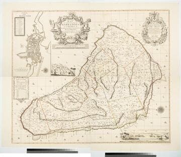
New and Exact Map of the Island of Barbadoes in America, According to an Actual and Accurate Survey made by William Mayo
Visual Materials
Kashnor notes, "Dedicated to James Bridges, Duke of Chandos. With inset plan of Bridgetown, prospect of Codrington College, and engraving representing the making of the survey; also statistics of population." See also 093:745M, another copy as engraved by John Senex 1722. Two elaborate cartouches. Submap - A Plan of Bridgetown. A view of Codrington College. View of surveyor with plane table, and native assistants with measuring wheel, surveying pole and chain. . Prime meridian: London. Relief: pictorial. Graphic Scale: Miles. Projection: Plane. Watermark: JW Whatman 1794. Printing Process: Copper engraving. Other Features: CartoucheSub-mapsVignettes. Verso Text: Ms notes: 174 4 sheets 23, 24, 25, 26..
105:174 M

Plan of the Island of Tobago, laid down by actual survey under the Direction of the Honorable the Commissioners for the Sale of Lands in the Ceded Island by John Byres Chief Surveyor 1776. I. Bayley Sculp London Republished 14 July 1794, by Robert Wilkinson No. 58 Cornhill
Visual Materials
Shows lands set aside by the Crown for "Poor Settlers." Prime meridian: London, Ferro. Relief: hachures. Graphic Scale: Miles, chains. Projection: Cylindrical. Printing Process: Copper engraving. Verso Text: MS notes: 839 43.
093:839 M
Image not available
A Map of the Located Districts in the Province of Upper Canada, Describing all the New Settlements, Townships, &c., with the adjacent Frontiers, Compiled and Corrected from the Latest Surveys in the Surveyor General's Office
Visual Materials
Kashnor notes, "A very fine large scale map,fully detailed, giving the most accurate view of Upper Canada 113 years ago. Shows all the counties west of Lake St. Clair, locating Sandwich and Amherstburg; also York, Queenston, Forts Chippewan and Erie. Buffalo is called New Amsterdam." "by William Chewitt, Senior Surveyor & Draughtsman, Under the Direction of Francis Gore Esq., Lieutenant Governor &c. &c. To whom this map is most respectfully inscribed, By William Faden, Geographer to His Majesty, and His Royal Highness the Prince Regent. Charing Cross January 1st. 1813." "Cooper Sculp." Prime meridian: GM. Relief: no. Graphic Scale: Miles. Projection: Pseudocylindrical. Printing Process: Copper engraving. Verso Text: MS notes: 684 T5 Faden Map of Upper Canada 1813.
105:684 M

To the Right Honourable Wills, Earl of Hillsborough, First Commissioner of Trade and Plantations, this Map of the County of Middlesex in the Island of Jamaica, laid down from the Papers and under the direction of Henry Moore, Esqre., His Majesty's Lieutenant Governor and Commander in Chief of the Island in the years 1756-1761 (and from a great number of Actual Surveys performed by the Publishers) is humbly Inscribed by His Lordship's Most Obedient & Most Humble Servants Thos. Craskell, Engineer, Jas. Simpson, Surveyor
Visual Materials
Kashnor notes, " A very fine topographical map, indicating the different kinds of palntations, roads, boundaries, &c." Torn center seam, careful. Cartouche: Boar hunt with dogs. Elaborate scale artwork upper right.. Relief: no. Graphic Scale: Miles. Projection: Plane. Printing Process: Copper engraving. Other Features: CartoucheArt Work.
105:467 M