Opening Hours
Daily: 10 A.M.–5 P.M.
Closed on Tuesdays
1151 Oxford Road
San Marino, CA 91108
Visual Materials
Daily: 10 A.M.–5 P.M.
Closed on Tuesdays
1151 Oxford Road
San Marino, CA 91108

Image not available
Visual Materials
Famous de l'Isle map with South America curving west. See 093:631 for Sanson's copy of this map. Cartouche: Figures & scrolling.. Prime meridian: Ferro. Relief: pictorial. Graphic Scale: Leagues. Projection: Pseudocylindrical. Watermark: Chained maltese cross. Printing Process: Copper engraving. Other Features: Cartouche. Verso Text: MS notes: 610 29.
093:610 M
![Carte du Mexique et de la Floride des Terres Angloises et des Isles Antilles du Cours et des Environs de la Riviere de Mississipi. Dresée Sur un grand nombre de memoires principalemt sur ceux de Mrs. d'Iberville et le Sueur. Par Guillaume Del'Isle Geographer de l'Academie Royale des Scie[n]ces A Paris Chéz l'Auteur sur le Quaide l'Horloge Privilege du Roy po.20 ans 1703](/_next/image?url=https%3A%2F%2Frail.huntington.org%2FIIIF3%2FImage%2F22APN4KV2YR6%2Ffull%2F%5E360%2C%2F0%2Fdefault.jpg&w=750&q=75)
Visual Materials
Kashnor notes, "Shows the country which soon afterwards belonged to the Mississippi Company, and gives a good map of New Mexico, locating Santa Fe and Taos." Ambiguous California, Colorado flows into Gulf of California, but at an angle. Floride and Nouvelle France merge in midcountry, English colonies hug the east coast, Mexico extends south to Panama. This is the second state per Rosenthal. See 093:465M for a later state of this map. Cartouche with natives. Erasures in scale area and inside cartouche.. Prime meridian: Ferro. Relief: pictorial. Graphic Scale: Miles, leagues. Projection: Pseudocylindrical. Watermark: Chained maltese cross I D with castle?. Printing Process: Copper engraving. Other Features: Cartouche. References: Cumming 137; Wheat 84; Tooley (Amer.) p.23; Schwartz pl.82; Wagner 474.. Verso Text: MS note: 464.
093:464 M
Image not available
Visual Materials
Kashnor notes, "Shows California with coast reaching to the Strait of Martin d'Aquilar. locating Nle. Albion; also shows a good map of New Mexico." Kashnor dates ca. 1750. RLIN record suggests 1766. Prime meridian: Ferro. Relief: no. Graphic Scale: Leagues. Projection: Pseudocylindrical. Watermark: Chained Maltese cross. Printing Process: Copper engraving. Other Features: Cartouche. Verso Text: MS note: 216.
105:216 S
Image not available
Visual Materials
Kashnor notes, "Shows New Mexico, and locates Santa Fe, Taos, and other towns. The course of the Missouri reaches above the junction of the R. de Panis, and Checagou is located on Lac de Illinois." Florida extends west to cover Texas, and north to include Kentucky. Cartouche with natives.. Prime meridian: Ferro. Relief: pictorial. Graphic Scale: Miles, leagues. Projection: Pseudocylindrical. Watermark: Chained Maltese cross. Printing Process: Copper engraving. Other Features: Cartouche. Verso Text: MS note: 93-399 27.
093:399 M
Visual Materials
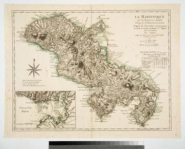
Copy of Jeffery's map. Submap: Cul de Sac Royal. Table of astronomical observations.. Prime meridian: Ferro. Relief: hachures. Graphic Scale: Leagues. Projection: Cylindrical. Watermark: Chained maltese cross lettering. Printing Process: Copper engraving. Other Features: Sub-maps.
093:817 M
Image not available
Visual Materials
Kashnor notes, "Shows the Californian coast to Cape Blanco, locating Pto. S. Francois Drack, Monterey, &c.; also Santa in New Mexico." Table of European possessions, divisions by language, religion, etc.. Prime meridian: Ferro. Relief: pictorial. Graphic Scale: Miles, leagues. Projection: Pseudocylindrical. Watermark: Chained Maltese cross lettering. Printing Process: Copper engraving. Verso Text: MS note: 283/105.
105:283 M