Visual Materials
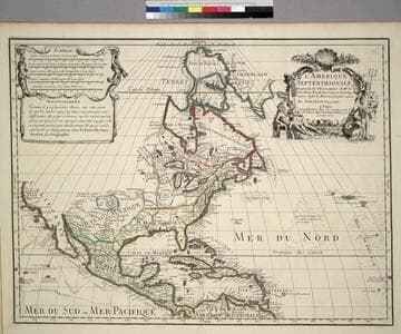
Carte de l'Amerique Septentrionale
You might also be interested in
Image not available
Carte de l'Amerique Septentrionale 1754
Visual Materials
Kashnor notes, "Shows the coast of California and the North-West to the supposed Strait of Anain." Kashnor states publication as Paris, dates as [1755] and attributes to [Jean Palariest]. See 093:167M for variant map. RLIN record identifies maker as Palairet, publication place as London, date as 1755. MS notes: Jean Palariat 1755. 13. (upper right). Prime meridian: Ferro. Relief: pictorial. Graphic Scale: Miles (naut.), leagues. Projection: Pseudocylindrical. Watermark: Crowned fluer-di-lis IV. Printing Process: Copper engraving. Other Features: Cartouche. Verso Text: MS notes: 217 .
105:217 M
Image not available
Carte de l'Amerique Septentrionale 1754
Visual Materials
Kashnor notes, "Shows the coast of California and the North-West to the supposed Strait of Anain. Kashnor states publication as Paris, dates as [1755] and attributes to [Jean Palariest]. See 105:217M for variant map. RLIN record identifies maker as Palairet, publication place as London, date as 1755. MS notes: By Jean Palariat 1755. 13. (upper right). Prime meridian: Ferro. Relief: pictorial. Graphic Scale: Miles (naut.), leagues. Projection: Pseudocylindrical. Watermark: Crowned fluer-di-lis IV. Printing Process: Copper engraving. Other Features: Cartouche. Verso Text: MS notes: 167 13.
093:167 M
Image not available
Nouveau (Le) Continent, ou l'Amerique divisée en Septentrionale ey Meridionale, ou l'on trouve, lers Climats, les Meridiens, les differentes Possessions, les Peuples Naturels Libres, les differentes Religions, et les differentes Langues
Visual Materials
Kashnor notes, "Shows the Californian coast to Cape Blanco, locating Pto. S. Francois Drack, Monterey, &c.; also Santa in New Mexico." Table of European possessions, divisions by language, religion, etc.. Prime meridian: Ferro. Relief: pictorial. Graphic Scale: Miles, leagues. Projection: Pseudocylindrical. Watermark: Chained Maltese cross lettering. Printing Process: Copper engraving. Verso Text: MS note: 283/105.
105:283 M
L'Amerique Septentrionale, Dresée sur les Observations de. Mrs. de l'Academie Royale des Sciences. & quelques autres, & sur les Memoires les plus recens
Visual Materials
Kashnor notes, " Shows the Gulf of California reaching only as far north as the Bona Guia River, the north-west coast has its limit at Cap Mendocin. It locates the Sierra Nevada Mountains, Port de Drak and New Albion, and also the tracks of Cortez, Drake, Olivier, Mendana and Gaetana. One of the best maps to show the geographical knowledge of California at the beginning of the 18th century." George Carhart of Osher Map Library confirms this map to be state 2, published in [1701]. See 093:160M for a later version of this map. Cartouche and figured scale bar. Includes Avertissement.. Prime meridian: Ferro. Relief: pictorial. Graphic Scale: Leagues, various. Projection: Pseudocylindrical. Watermark: Chained Maltese cross. Printing Process: Copper engraving. Other Features: CartoucheFigures . Verso Text: MS notes: 72 (on folded left edge); 159 Mus. Bk St. 93/159 25.
093:159 M
Image not available
Carte du Paraguay, du Chili, du Détroit de Magellan &ca. Dressée sur les Descriptions des PP. Alfonse d'Orvalle, et Nicolas Techo, et sur les Relations et memoires de Brouwer, Narbouroug, Me. de Beauchesne &c. Par Guillaume De L'Ilse Geographe de l'Academie Royale des Sciences
Visual Materials
Kashnor notes, "Locates the borders of La Plata, Uruguay, and Paraguay." This is a copy of Visscher's map, see 093:632. See also 093:634, 093:635 for other versions. RLIN record suggests print date is actually 1718. Cartouche: Figures.. Prime meridian: Ferro. Relief: pictorial. Graphic Scale: Leagues. Projection: Pseudocylindrical. Watermark: Chained maltese cross lettering. Printing Process: Copper engraving. Other Features: Cartouche. Verso Text: MS note: 633 3J.
093:633 M
Image not available
Carte des Etats-Unis de l'Amerique Septentrionale Dresée Par. P. Tardieu
Visual Materials
Kashnor notes, "One of the most accurate maps of the day, locating all of the discoveries of Lewis and Clark, the international boundary reaches only to the Rockies, Oregon being evidently no man's land, for the Mexican boundary is at the 42nd parallel.. Locates San Francisco, Monterey, and other old Spanish settlements." Shows River S. Phillippe flowing from Utah to California coast south of Monterey. Prime meridian: Washington, DC. Relief: hachures. Graphic Scale: Miles, leagues. Projection: Pseudocylindrical. Printing Process: Engraving. Verso Text: MS notes: Etats Unis (Warden) shown twice. Attached hexagonal seller's seal - Auvray Marchand d Estampes et de Cartes Géographiques. Quai Malaquais No. 11. A Paris. MS note: 166 (on seal) Seal has tag extending above top edge of map..
093:166 S