Visual Materials
Plan of Port Royal in South Carolina Survey'd by Capn. John Gascoigne

You might also be interested in
Image not available
A Plan of Port Royal in South Carolina Survey'd by Capn. John Gascoigne
Visual Materials
Kashnor notes, "A very rare war map of South Carolina. It shows the different islands, the chief plantations, the soundings of the harbour and rivers, and indicates places of military importance." [note from 093:380] [Hilton Head Island is named Trench's Island on this map.] See 093:380 for an earlier version of this map. The RLIN record covers an earlier version printed by Jefferys & Faden. Sailing directions.. Prime meridian: London. Relief: no. Graphic Scale: Miles. Projection: Plane. Printing Process: Copper engraving. Verso Text: MS note: 348.
105:348 M
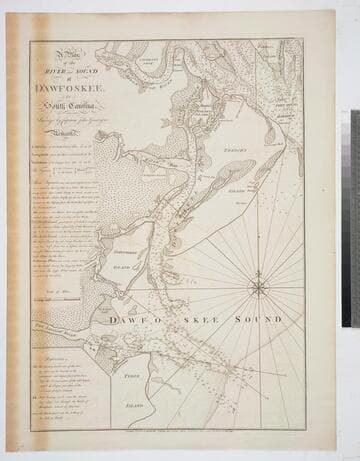
A Plan of the River and Sound of D'Awfoskee, in South Carolina. Survey'd by Captain John Gascoigne
Visual Materials
MS note: c 36. Prime meridian: London. Relief: no. Graphic Scale: Miles. Projection: Plane. Watermark: Crowned fleur-di-lis VI. Printing Process: Copper engraving. Verso Text: MS note: 349 10.
105:349 M

To the Right Honourable John Lord Sommers.; This Map of North America According to the Newest and most Exact Observations is most Humbly Dedicated by your Lordship's most humble Servant Herman Moll Geographer
Visual Materials
Kashnor notes,"Shows a good map of the Far West, according to knowledge at the time particularly of New Mexico. California is still an island and there is a river which is in the locality of the Columbia." Map includes famous fish drying vignette, and is known as the "Cod Fish" map. McLaughlin dates as 1719. Note this is probably an earlier state, missing John King from map sellers mentioned by McLaughlin. Cartouche: Indians & Eskimos, Moll armorial. Fish drying vignette. Submaps: St John's Harbour, Boston Harbour, New York Harbour, Charlestown Harbour, Port Royal Harbour, Havana Harbour, Pto. Bello Harbour, La Vera Cruz, Cartagena Harbour, Port of Acapulco. . Prime meridian: London. Relief: pictorial. Projection: Azimuthal. Printing Process: Copper engraving. Other Features: CartoucheVignettesSub-maps. References: McLaughlin 192; Wagner 514; Wheat 105; Tooley 82; Leighly 145; Stevens No. 7; Goss 53 (plate).. Verso Text: MS notes: No. 7 G D 213.
093:213 M
Image not available
Chart of the River la Plata, from its Mouth up to Buenos-Ayres. Surveyed by Order of the King of Spain in the Year 1789. Revised and corrected in 1794, by several Officers of the Royal Navy
Visual Materials
Shows tracks and soundings of HMS Diomede and Leda for Second edition, and HMS Woolwich for Third Edition information. Vignettes: View of the coast between Point of la Sierra & that of la Ballena/ the Whale: view of the Island of Lobos/ Sea Wolf Island. Submaps: Plan of the Harbour of Maldanado, On the North Shore of River La Plata, at its mouth, Surveyed in 1789: Plan of the Harbour of Montivedeo, on the North Shore of the River La Plata, Surveyed in the Year 1789.. Prime meridian: GM, Cadiz. Relief: hachures. Graphic Scale: Leagues. Projection: Cylindrical. Printing Process: Copper engraving. Other Features: VignettesSub-maps. Verso Text: MS notes: 637 23.
093:637 M
Image not available
[Chart of the Coast of Georgia, South and North Carolina]
Visual Materials
Kashnor notes, "with inset charts of Charlestown Harbor, Cape Fear River and St. Mary's Inlet; also views of the entrance to Charlestown Harbour, seen North and South of Sullivan's Island, a scarce chart." Submaps: St. Mary's Inlet; Charleston; Cape Fear River. Vignettes: Appearance of the entrance to St. Mary's River from the bar; Appearance of Cape Roman, bearing N.b.W. distance 4 leagues; Charleston Churches, appearing Northward of Sulivans Island, there will be 5-1/2 fathoms on the Rattlesnake, but do not come any nearer than 5 fathoms; Charleston Churches, appearing Southward of Sulivan's Island clears the Rattlesnake.. Prime meridian: London. Relief: no. Projection: Mercator. Printing Process: Copper engraving. Other Features: VignettesSub-maps. Verso Text: Ms note: 363.
093:363 M

Survey of Prince Edward Island
Visual Materials
Kashnor notes, "Including soundings, banks, shoals &c., on the coast." This map is a derivative map of 105:754. This map has penciled corrections which then show up on the 1825 corrected version, 105:757. Submaps: Gulf of St. Lawrence; Holland Harbour. Lengthy printed description of the island glued to lower section, partly hiding information provided on 105:757.. Prime meridian: GM. Relief: no. Graphic Scale: Miles. Projection: Plane. Printing Process: Copper engraving. Other Features: Sub-maps. Verso Text: MS note: 756.
105:756 M