Visual Materials
A Plan of Port Royal in South Carolina Survey'd by Capn. John Gascoigne
You might also be interested in

Plan of Port Royal in South Carolina Survey'd by Capn. John Gascoigne
Visual Materials
Kashnor notes, "A very rare war map of South Carolina. It shows the different islands, the chief plantations, the soundings of the harbour and rivers, and indicates places of military importance." [Hilton Head Island is named Trench's Island on this map.] See 105:348 for a later version of this map. Sailing directions. Beautifully hand colored.. Prime meridian: London. Relief: no. Graphic Scale: Miles. Projection: Plane. Printing Process: Copper engraving. Verso Text: MS note: 380.
093:380 M
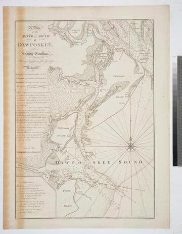
A Plan of the River and Sound of D'Awfoskee, in South Carolina. Survey'd by Captain John Gascoigne
Visual Materials
MS note: c 36. Prime meridian: London. Relief: no. Graphic Scale: Miles. Projection: Plane. Watermark: Crowned fleur-di-lis VI. Printing Process: Copper engraving. Verso Text: MS note: 349 10.
105:349 M
Image not available
United States of North America, with the British & Spanish Territories and those of Spain, according to the Treaty of 1784
Visual Materials
Kashnor notes, "Similar to Faden's map of "The British Colonies in North America," with the addition of colored contours indicative of the British, Spanish, French and American frontiers." "Engraved by Wm. Faden." See 105:148 for an earlier copy, 093:544, 093:545 for later copies. RLIN record adds appeared in information. Cartouche of Caribbean traders.. Prime meridian: London. Relief: pictorial. Projection: Pseudocylindrical. Printing Process: Copper engraving. Other Features: Cartouche. Verso Text: MS notes : 654 Faden U.S.A. 1793.
105:654 M
Image not available
The River St. Lawrence, accurately drawn from D'Anville's Map Published under the patronage of The Duke of Orleans
Visual Materials
Latitude and Longitude lines for Quebec marked. "Engraved for J. Harrison, No. 115 Newgate St. London" "Simpkins Sculp. 251 Strand." See also 093:352M, 105:788M (duplicates) and 093:357M for an earlier French version of this map. Relief: no. Graphic Scale: Leagues. Projection: Cylindrical. Printing Process: Copper engraving. Verso Text: MS note: 787 .
105:787 M
Image not available
The River St. Lawrence, accurately drawn from D'Anville's Map Published under the patronage of The Duke of Orleans
Visual Materials
Latitude and Longitude lines for Quebec marked. "Engraved for J. Harrison, No. 115 Newgate St. London" "Simpkins Sculp. 251 Strand. 24 (upper right)" See also 093:352M, 105:788 (duplicates) and 093:357M for an earlier French version of this map. Relief: no. Graphic Scale: Leagues. Projection: Cylindrical. Printing Process: Copper engraving. Verso Text: MS note: 788.
105:788 M

Plan of Port Royal Harbor in Carolina with the Proposed Forts, Depth of Water, &c. Latitude 32D-6 North. According to an Origenal (sic) Draught by H. Moll
Visual Materials
Kashnor notes, "A scarce map locating the fort at Helena Island." Worm holes indicate this map came from the same volume as 093:360S. See 093:379S for another copy. MS note: 5, upper right. Ms note: 378 (on backing). Relief: no. Graphic Scale: Miles. Projection: Plane. Printing Process: Copper engraving. Verso Text: Ms note: 378 (on backing).
093:378 S