Rare Books
The West Indies : exhibiting the English, French, Spanish, Dutch & Danish settlements collected from the best authorities / by Thomas Jefferys, Geographer to the King
You might also be interested in

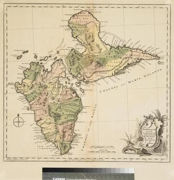
West Indies Exhibiting the English, French, Spanish, Dutch & Danish Settlements. Collected from the best Authorities by Thomas Jefferys, Geographer to the King
Visual Materials
Kashnor notes, "This map also shows part of Carolina, Florida, Georgia, Louisisana, and all Mexico west to the peninsula of California, as well as Central America." Kashnor dates as [1770]. RLIN record suggests print date as early as 1760. Cartouche: Bower with birds and flowers.. Prime meridian: Lopndon. Relief: pictorial. Graphic Scale: Miles, leagues. Projection: Azimuthal. Watermark: Crowned fleur-di-lis WL. Printing Process: Copper engraving. Other Features: Cartouche. Verso Text: MS note: 733 37.
093:733 M
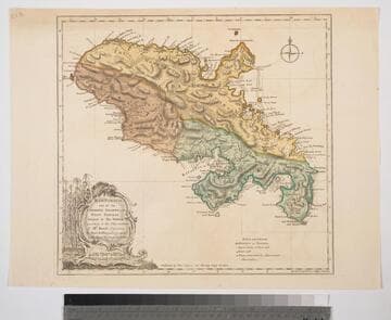
Guadaloupe one of the Caribbee Islands Subject to France in the West Indies, from the Best Authorities By T. Jefferys
Visual Materials
Kashnor dates as [1760]. RLIN record suggests 1768 and provides appeared in information. Cartouche: water falls & plants. Oversize binding spine still attached. Note: mile and league scales do not match.. Prime meridian: Ferro, London. Relief: pictorial & hachures. Graphic Scale: Miles, leagues. Projection: Cylindrical. Watermark: Crowned fleur-de-lis VI. Printing Process: Copper engraving. Other Features: Cartouche. Verso Text: MS notes: 93/775 148 La Guadaloupe La Guadalupe .
093:775 M
Image not available
North America From the French of M. d'Anville: Improved with the Back Settlements of Virginia and Course of the Ohio
Visual Materials
Kashnor notes, "A scarce map reduced from Jefferys' map." Kashnor dates as [1755]. This is a reprint of the Jefferys/ Anville map of 1755, see McCorkle 755.2 for other variations. This one is apparently not listed. "R. Cole sculp." Cartouche: flowered. MS note: 640 (on backing). Prime meridian: Ferro. Relief: pictorial. Graphic Scale: Miles. Projection: Pseudocylindrical. Printing Process: Copper engraving. Other Features: Cartouche.
105:640 S
Martinico, one of the Caribbee Islands, in the West Indies; Subject to the French. according to Observations of Mr. Houel Engineer, by Thos. Jefferys, Geographer ti His Royal Highness the Prince
Visual Materials
Kashnor dates ca. 1760. Cartouche: framed with sugar cane. MS note: 813. Prime meridian: Ferro, London. Relief: hachures. Graphic Scale: Miles, leagues. Projection: Cylindrical. Watermark: Crowned fluer-di-lis over IVC. Printing Process: Copper engraving. Other Features: Cartouche. Verso Text: M
093:813 S

The West Indies, Exhibiting the English French Spanish Dutch & Danish Settlements with the Adjacent Parts of North & South America, from the best Authorities
Visual Materials
Kashnor notes, "Showing the settlements of the Caribbee Islands effected by the Treaty of 1783." Kashnor dates as ca. 1790. This may be a reduced size version of I. Prockter's 1762 map. MS note: 975 (on backing). Prime meridian: Ferro. Relief: pictorial. Projection: Cylindrical. Printing Process: Copper engraving.
105:975 S
Image not available
Chart of the Atlantic Ocean, with the British, French & Spanish Settlements in North America and the West Indies; and also on the Coast of Africa / by Thos. Jeffreys Geographer to His Majesty
Rare Books
This may be Jefferys' copy of John Green's map. It has two overlays, Plate 1 is "Claims of the French in 1756 are colored in yellow." Plate II is "The French Dominions as proposed by M. de Bussy in 1761 are colored yellow and the lands proposed by M. de Bussy to be neutral are colored Green." The main map is designated as Plate III. "The Dominions ceded by France & Spain to Great Britain in 1762 are colored with a feint Red..." Prime meridian: London, Ferro. Relief: no. Projection: Cylindrical. Printing Process: Copper engraving. MS note: Published Feb. 7 1763.
295814