Visual Materials
North America From the French of M. d'Anville: Improved with the Back Settlements of Virginia and Course of the Ohio
You might also be interested in
Image not available
North America From the French of Mr. D'Anville Improved with the Back Settlements of Virginia and Course of Ohio Illustrated with Geographical and Historical Remarks
Visual Materials
Kashnor notes, " 'Canada, & the French Incroachments are distinguished by Yellow; the Spanish Settlements by Green; and the English Colonies by other Colours.' There is a long note on the history of the French encroachment, and the aggressive French forts are clearly indicated. The map was issued to counteract the assertions of the French Memorial which had been circulated to prove the justification for the encroachments." Classic cartouche. Much text on territorial claims.. Prime meridian: London, Ferro. Relief: pictorial. Graphic Scale: Miles, Leagues. Projection: Pseudocylindrical. Printing Process: Copper engraving. Other Features: Cartouche. Verso Text: MS note: 670.
105:670 M
Image not available
North America from the French of Mr. d'Anville Improved with the Back Settlements of Virginia and Course of Ohio Illustrated with Geographical and Historical Remarks
Visual Materials
Note this is the same map as 093:533M by Sayer & Bennett. It is dated ten years prior to 093:533M and includes a lengthy discussion of English titles to their settlements and French encroachments. Lengthy description of English titles to various properties. Cartouche: Flowers and water falls.. Prime meridian: London, Ferro. Relief: pictorial. Graphic Scale: Miles, leagues. Projection: Pseudocylindrical. Printing Process: Copper engraving. Other Features: Cartouche. References: McCorkle 755.2. Verso Text: MS note: 534 "Mr Booth to be left at Georges Coffee House Temple Bar.".
093:534 M
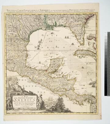
Map of the British Empire in America With the French, Spanish and the Dutch Settlements adjacent thereto by Henry Popple
Visual Materials
Kashnor notes, "Copied from Popple's map With the titles in English and French. ShoWs Carolina divided into counites, With Georgia and the Forts neWly erected, and Savannah." Kashnor dates as ca. 1740, RLIN record suggests 1755. Cartouche of Indians, traders. MS note: No. 10. Relief: pictorial. Projection: Cylindrical. Printing Process: Copper engraving. Other Features: Cartouche. References: McCorkle [741.2]. Verso Text: MS note: 326.
105:326 M
Image not available
North America from the French of Mr. D'Anville : improved with the back settlements of Virginia and course of Ohio illustrated with geographical and historical remarks
Rare Books
A description of the English titles to the land in some length is counterbalanced by a list of "French Incroachments." Uncolored although the planned color scheme is noted on the map. MS note: 84000 Cartouche: Columns & waterfalls. Prime meridian: London, Ferro. Relief: pictorial. Graphic Scale: Miles, leagues. Projection: Conic. Watermark: VVI; device. Printing Process: Copper engraving.
84000
Image not available
North America from the French of Mr. d'Anville Improved with the English Surveys made since the Peace
Visual Materials
Kashnor notes, "Locates Chicago and gives a good map of the Illinois country and the country around the headwaters of the Mississippi, and the old forts and towns of the Ohio country." See 093:534M for an earlier version by Jefferys. RLIN record adds appeared in information. Prime meridian: London, Ferro. Relief: pictorial. Graphic Scale: Miles, leagues. Projection: Pseudocylindrical. Watermark: Crowned fleur-di-lis over GR. Printing Process: Copper engraving. References: McCorkle 755.2 (1775 state). Verso Text: MS note: 533.
093:533 M
Image not available
A Map of the British and French Settlements in North America
Visual Materials
Kashnor notes, "shewing the French encroachment and forts, and with an account of the English claims to the territories in dispute." Kashnor dates as ca. 1756. RLIN record suggests 1750-59. Cartouche includes Lodge's name. Detailed history of various English colonies. MS note: 622 (on backing).. Prime meridian: London. Relief: pictorial. Projection: Mercator. Printing Process: Copper engraving. Other Features: Cartouche. Verso Text: MS notes: 63 G47.
105:662 S