Visual Materials
West Indies Exhibiting the English, French, Spanish, Dutch & Danish Settlements. Collected from the best Authorities by Thomas Jefferys, Geographer to the King

You might also be interested in
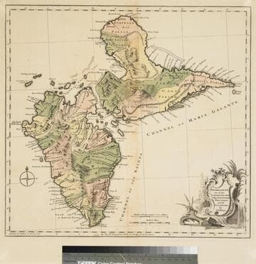
Guadaloupe one of the Caribbee Islands Subject to France in the West Indies, from the Best Authorities By T. Jefferys
Visual Materials
Kashnor dates as [1760]. RLIN record suggests 1768 and provides appeared in information. Cartouche: water falls & plants. Oversize binding spine still attached. Note: mile and league scales do not match.. Prime meridian: Ferro, London. Relief: pictorial & hachures. Graphic Scale: Miles, leagues. Projection: Cylindrical. Watermark: Crowned fleur-de-lis VI. Printing Process: Copper engraving. Other Features: Cartouche. Verso Text: MS notes: 93/775 148 La Guadaloupe La Guadalupe .
093:775 M
Image not available
A Map of South America With all the European Settlements & whatever else is remarkable from the latest & best Observations
Visual Materials
Kashnor dates as ca. 1770. RLIN record indicates this may be as early as 1745. Cartouche: frilled. Stain upper right from material stuck to verso.. Prime meridian: London. Relief: pictorial. Projection: Azimuthal. Watermark: Crowned fleur-di-lis VI. Printing Process: Copper engraving. Other Features: Cartouche. Verso Text: MS note: 849.
105:849 S
Image not available
Map of North America With the European Settlements & whatever else is remarkable in the West Indies, from the latest and best Observations
Visual Materials
Kashnor notes, "Copied from an old map, and still showing California as an island and La Hontan's River Longue. Locates Po. Sir Francis Drake, M. Nevada, and Mt. St. Martin." RLIN record gives printing location and appeared in information. Kashnor dates ca. 1740, RLIN record suggests [1745?], McLaughlin lists [1745]. Prime meridian: London. Relief: pictorial. Projection: Conic. Watermark: Fleur-di-lis. Printing Process: Copper engraving. Other Features: Cartouche. References: McLaughlin 228; Wheat 124,202; Tooley 97; Leighly 173 (Plate XXIII). Verso Text: MS notes: 105 #241.
105:241 S
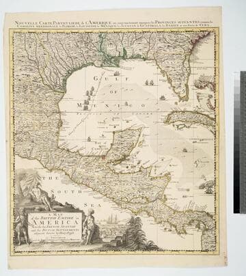
Map of the British Empire in America With the French, Spanish and the Dutch Settlements adjacent thereto by Henry Popple
Visual Materials
Kashnor notes, "Copied from Popple's map With the titles in English and French. ShoWs Carolina divided into counites, With Georgia and the Forts neWly erected, and Savannah." Kashnor dates as ca. 1740, RLIN record suggests 1755. Cartouche of Indians, traders. MS note: No. 10. Relief: pictorial. Projection: Cylindrical. Printing Process: Copper engraving. Other Features: Cartouche. References: McCorkle [741.2]. Verso Text: MS note: 326.
105:326 M
Image not available
The West Indies : exhibiting the English, French, Spanish, Dutch & Danish settlements collected from the best authorities / by Thomas Jefferys, Geographer to the King
Rare Books
Pieced together from two separate sheets; the sheet on the right that appeared in The natural and civil history of the French dominions in North and South America by Thomas Jefferys, 1760, volume 2; page 1 (RB 148808). Cartouche: flowered. Prime meridian: London, Ferro. Relief: pictorial. Graphic Scale: Miles, Leagues. Projection: Pseudocylindrical. Printing Process: Copper engraving.
480571
Image not available
New Map of Nova Scotia, and Cape Breton Island with the adjacent parts of New England and Canada, Composed from a great number of actual Surveys; and other material Regulated by many new Astronomical Observations of the Longitude as well as Latitude; by Thomas Jefferys, Geographer to the King
Visual Materials
See map 093:270M for later edition. RLIN record provides appeared in information. Kershaw identifies this as the fourth state of Jefferys' map. Prime meridian: Ferro. Relief: pictorial. Projection: Conic. Watermark: Crowned fleur-di-lis VI. Printing Process: Copper engraving. Other Features: Cartouche. References: Kershaw 745; LC Phillips 1166,1208. Verso Text: MS note: 269.
093:269 M