Rare Books
Mapp of the Improved Part of Pensilvania in America, Divided into Counties, Townships and Lotts
You might also be interested in
Image not available
A Map of the Improved Part of the Province of Pennsilvania in America
Rare Books
An 1870 facsimile of an earlier map showing land ownership. Cartouche: Figures, coat of arms. Sub map: City of Philadelphia. "Begun by William Penn Proprietary & Governor therof Anno 1681." "[Original]To the Worthey William Penn Esq. Proprietor of Pennsilvania in America This map is Humbly Dedicated by John Thornton & Robert Greene. Sold by Rob. Greene at the Rose & Crown in Budgrow and by John Thornton at the Platt in the Minories London." "Fac Simile of Holmes' Map of the Province of Pennsylvania with the names of the original Purchasers from William Penn begun in 1681" "Entered according to Act of Congress in the year 1870, by Charlers L. Warner, in the office of the Librarian of Congress at Washington, D.C." "Engd. by Worley & Bracher. Printed by Fred Bourquin." Prime meridian: GM. Relief: no. Graphic Scale: Miles. Projection: Plane. Printing Process: Lithography. Other Features: Cartouche Sub-maps.
128412
Image not available
Map of the most Inhabited part of New England containing the Provinces of Massachusets Bay and New Hampshire, with the Colonies of Conecticut and Rhode Island, Divided into Counties and Townships: The whole composed from Actual Surveys and its situation adjusted by Astronomical Observations
Visual Materials
Kashnor notes, "This is the old Colonial Map, originally engraved and issued by Thomas Jefferys, the plate having passed into the possession of the firm when the Jefferys and Sayer, and Sayer and Bennett firms became Laurie and Whittle." Two submaps. Patterned after Jeffreys' 1755 map, see McCorkle 755.19. Cartouche: Landing of the Mayflower at Plymouth. Submaps: Plan of the Town of Boston; Plan of Boston Harbor from an Accurate Survey.. Prime meridian: London. Relief: pictorial. Graphic Scale: Miles, leagues. Projection: Cylindrical. Printing Process: Copper engraving. Other Features: Sub-mapsCartouche. References: McCorkle 755.19.. Verso Text: MS notes: 457 England 4 Sheets (one sheet)..
093:457 M

A new and general map of the middle dominions belonging to the United States of America, viz. Virginia, Maryland, the Delaware-Counties, Pennsylvania, New Jersey &c. with the addition of New-York, & of the greatest part of New England &c. as also of the bordering parts of the British possessions in Canada
Rare Books
Kashnor notes, "This is an unrecorded issue of Lewis Evans' famous map. According to Stevens in his monograph on Lewis Evans, this is the eighteenth issue, but in this the words Province of Quebec still extend from below the Wabash, whereas in the issues noted by him the words "Province of" have been deleted." "viz. Virginia, Maryland, the Delaware-Counties, Pennsylvania, New Jersey &c. with the Addition of New York, & of the Greatest Part of New England &c. as also of the Bordering Parts of the British Possessions in Canada." Sub map: Sketch of the Upper Parts to show the remainder of the Lakes. Prime meridian: London, Philadelphia. Relief: pictorial. Graphic Scale: Miles, Leagues. Projection: Pseudocylindrical. Printing Process: Copper engraving. Other Features: Sub-maps. Verso Text: MS notes: 631 L32 195046.
195046
Image not available
A New Map of the Whole Continent of America, divided into North and South and West Indies
Rare Books
This map is a later version of the Sayer & Bennett map of 1777, see 093:199M, also 093:218M for 1786 version. Insert map of Baffin's and Hudson's Bays. This map now shows Vancouver Island and corrects the River of the West, adding more exact information about the Pacific Northwest. The provisions of the 1763 Versailles treaty are removed, and instead the "Preliminaries of Peace signed at Versailles Jan 20,1783" are noted. Maine's border revised. Kashnor notes, "One of the earliest maps to show the discoveries of Vancouver, locating the island bearing his name, and the Columbia River. Shows Nootka Sound. The map was issued at a time when the troubles over the Nootka question had lately been settled." This map duplicates 105:269. Cartouche w. alligator. Table delineating possessions of European nations now revised to include United States information Sub-map: The Supplement to North America containing the countries adjoining Baffins & Hudsons Bays. "Compiled from Mr. D'Anville's Maps of that Continent, with the addition of the Spanish Discoveries in 1775 to the North of California & corrected in the Several Parts belonging to Great Britain, from the Original Materials of Governor Pownall, M.P." Prime meridian: Ferro. Relief: pictorial. Graphic Scale: Miles, leagues. Projection: Pseudocylindrical. Printing Process: Copper engraving. Other Features: Cartouche Sub-maps. Verso Text: MS notes: 35 36 50 150262.
150262
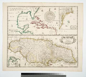
General Mapp of the Continent and Islands which bee adjacent to Jamaica
Visual Materials
Kashnor notes, "Shows Carolina on the large map, and New England, Virginia and Carolina on the smaller map of the English Empire." This is four maps in one. The map of Jamaica is larger than the principal map. Two smaller maps show the English Empire, and a New Draught of Port Royal by Anthony Williams. Four maps on one sheet.. Prime meridian: London. Relief: pictorial. Graphic Scale: Miles. Projection: Mercator. Printing Process: Copper engraving. Other Features: Sub-maps. Verso Text: MS note: 322 SI.
105:322 M

Survey of Lake Champlain, including Lake George, Crown Point and St. John. Surveyed by Order of His Excellency Major General Sr. Jeffery Amherst, Knight of the most Honble. Order of the Bath, Commander in Chief of His Majesty's Forces in North America, (now Lord Amherst) by William Brassier, Draughtsman, 1762
Visual Materials
Kashnor notes, "A rare map, issued specially for British Troops serving in the Revolutionary War." Sub map of Lake George Surveyed in 1756 by Capt. Jackson. Shows naval action at Valcour Island and Buttonmold Bay in Oct. 1776. Sub map of Lake George, Surveyed in 1756. by Capt. Jackson.. Relief: hachures. Graphic Scale: Miles, British. Projection: Plane. Watermark: Crowned fleur-di-lis V I. Printing Process: Copper engraving. Other Features: Sub-maps. Verso Text: 18 MS note: 112.
093:112 M