Visual Materials
General Mapp of the Continent and Islands which bee adjacent to Jamaica

You might also be interested in

A New Map of the English Plantations in America. both Continent and Islands, Shewing their true situtation and distance from England or one with another
Visual Materials
Kashnor notes: "Shows Carolina, locating Charles Town, Port Royal, Port Carteret, &c.; also Virginia, Maryland, New York, and New England. A fine map issued before Pennsylvania was founded." Kashnor dates as ca. 1680. Cartouche with Natives. MS note: 1680 Submap: North Atlantic, polar view.. Relief: pictorial. Graphic Scale: Miles. Projection: Pseudocylindrical. Watermark: PL. Printing Process: Copper engraving. Other Features: CartoucheSub-maps. References: McCorkle 673.1. Verso Text: MS note: 105-338.
105:338 M
Image not available
Columbia Prima or South America, in which has been attempted to dedicate the Extent of our Knowledge of that Continent
Visual Materials
Kashnor notes, "Coloured in indication of nationalities. A magnificent map of South America, from Santiago to Cape Horn, affording a complete and accurate view of the great Spanish Empire on the eve of its dissolution. It indicates the location of the various Indian nations, e.g. the 'Aracuyas,' who 'live chiefly on tiger's flesh'; the 'Los Plateros' or Silversmiths, 'now extinct'; the 'Mavorunas, called by the Spaniards Los Barbudos, the Bearded Nation, the only one in Spanish America,' &c. The attempt here to map out interior Brazil is particularly interesting." "Extracted Chiefly from the Original Manuscript Maps of His Excellency the late Chevarier Pinto; Likewise from those of Joao Joaquim da Rocha, Joao da Costa Ferreira. El Padre Francisco Manuel Sobreviela &c. and from the most authentic edited accounts of those countries. Digested / Constructed by The late eminent and learned Geographer Louis Stanislaus Darcy de la Rochette." Prime meridian: London. Relief: hachures. Graphic Scale: Miles, leagues. Projection: Pseudocylindrical. Printing Process: Copper engraving. Verso Text: MS notes: 842 four sheets 38 38* 38** 38***.
105:842 M

A new and exact map of the dominions of the King of Great Britain on ye continent of North America : containing Newfoundland, New Scotland, New England, New York, New Jersey, Pensilvania, Maryland, Virginia and Carolina ; according to the newest and most exact observations / by Herman Moll Geographer
Rare Books
Five maps in one with the wonderful beaver vignette with full explanation. Elaborate cartouche. Insets: [South part of Carolina and the east part of Florida] -- A map of the improved part of Carolina with the settlements &c. / by Her. Moll, geographer -- A draught of [the] town and harbour of Charles-Town -- A map of the principal part of North America. Vignette: Beaver scene. Prime meridian: GM. Relief: hachures. Graphic Scale: Miles, leagues [one section]. Projection: Cylindrical. Printing Process: Copper engraving. Verso Text: MS notes: Maps - Carolina; Herman Moll; London 1715. 44058.
44058

A new and exact map of the dominions of the King of Great Britain on ye continent of North America : containing Newfoundland, New Scotland, New England, New York, New Jersey, Pensilvania, Maryland, Virginia and Carolina ; according to the newest and most exact observations / by Herman Moll Geographer
Visual Materials
Five maps in one with the wonderful beaver vignette with full explanation. Elaborate cartouche. Insets: [South part of Carolina and the east part of Florida] -- A map of the improved part of Carolina with the settlements &c. / by Her. Moll, geographer -- A draught of [the] town and harbour of Charles-Town -- A map of the principal part of North America. Vignette: Beaver scene. Prime meridian: GM. Relief: hachures. Graphic Scale: Miles, leagues [one section]. Projection: Cylindrical. Printing Process: Copper engraving. Hand colored. Verso Text: MS notes: Maps - Carolina; Herman Moll; London 1715.
093:370
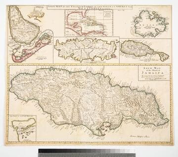
Map of the English Empire in the Ocean of America or West Indies, revised by J. Senex; A New Map of the Island of Jamaica; Barbados & Bermuda; Tobago; Antego; St. Christophers; Harbour at Port Royall
Visual Materials
Kashnor notes," The map of Bermuda locates all the tribes." This map is eight maps on one sheet. See 105:192 for earlier version of this map. Eight maps on one sheet. MS notes: 10 Sen 0 Savanna, signifies a Plain . Relief: pictorial. Graphic Scale: varies. Projection: Plane. Printing Process: Copper engraving. Other Features: Sub-maps. Verso Text: MS note: 191.
105:191 M

A New Map of the West Indies; or the Islands of America in the North Sea
Visual Materials
Kashnor notes, :Shows the coast of present-day Texas, and locates the Acansa and Teaucas Land, 'The People about this river are continually in Wars with the Spaniards'." Four harbor submaps. Submaps: A Draught of the Bay & City of Havana; The Bay of Porto Bella; A Draught of the Sity of Cartogena, its Harbour & Forts; La Vara Cruz. Cartouche: Soldiers, battle.. " With the Adjacent Parts, Explaining what belongs to England, Holland, Spain, France, &c. Also the Several Tracts made by the Gallions and Flota. by N. Vischer of Amsterdam. Is now done into English with many Considerable improvements according to the Newest and Best Observations." Prime meridian: Ferro. Relief: pictorial. Graphic Scale: Miles, leagues. Projection: Cylindrical. Printing Process: Copper engraving. Other Features: Sub-mapsCartouche.
105:800 M