Visual Materials
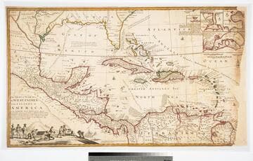
A New Map of the West Indies; or the Islands of America in the North Sea

You might also be interested in

A Map of the West-Indies or the Islands of America in the North Sea
Visual Materials
Kashnor notes, "The map also shows parts of Louisiana and South Carolina, and Central America. It is dedicated to William Paterson, the promoter of the Darien Colony." Kashnor dates as ca. 1720. View of Mexico City. Five submaps. See also 105:328M for another copy. View of Mexico City with building key; Submaps: St. Augustine; Vera Cruz; Havana; Darien; Cartagena.. "with the adjacent Countries; explaning [sic] what belongs to Spain, England, France, Holland &c. also the Trade Winds, and the several Tracts [sic] made by the Galeons [sic] and Flota from place to place. According to the Newest and most Exact Observations by Herman Moll Geographer." "To Wil. Paterson Esq; This map of the West-Indies &c. is most Humbly Dedicated by Herman Moll Geographer." Prime meridian: London. Relief: pictorial. Graphic Scale: Miles, leagues. Projection: Pseudocylindrical. Printing Process: Copper engraving. Other Features: VignettesSub-maps. Verso Text: MS notes: 958.
105:958 M
The Seat of the War in the West Indies, or the Islands of America in the North Sea
Visual Materials
Kashnor notes, "Issued during the War of the Spanish Succession, and makes a special feature of showing the tracks of the Spanish galleons. Has the declaration of Moll that the map of Mortier is not correct, he has 'vainly assumed the title of Geographer, tho he understands nothing of a map.' " Opening treasure boxes marked w fleur-de-lis. Submaps: Vera Cruz, Cartegena, Havana, Porto Bello.. "Together with the adjacent Dominions; Explaining what belongs to Spain, England, France, Holland, &c. As also the several Tracts made by the Galleons and Flota from place to place, with other considerable Improvements according to the Newest and best Observations. By Robert Morden & Herman Moll." Relief: pictorial. Graphic Scale: Leagues, miles. Projection: Conic. Printing Process: Copper engraving. Other Features: VignettesSub-maps. Verso Text: MS note: D32.
105:971 L
Image not available
North America and the West Indies;
Visual Materials
Kashnor notes, "An exceedingly rare map, shoWing the country West of the Mississippi, the boundaries of Virginia, North and South Carolina, reaching to that river. The inset map of the country locates Old Forts EdWard, William Henry, Frederic, St. John, and Chamilles to the St. LaWrence, and Albany, Schenectadi, Forts Hunter and OsWego to Lake Ontario." Kashnor dates as ca. 1764. Submaps and treaty articles. See 093:532 for another copy. "a NeWMap, Wherein the British Empire and its limits, according to the difinitive (sic) Treaty of Peace in 1763, are accurately described, and the Dominions possessed by the Spaniards, the French and other European States; the Whole compiled from the NeWSurveys and Authentic Memoirs that have hitherto appeared. " Cartouche With Natives. Submaps: Particular Map of Baffin and Hudson's Bay; Map of the Country betWeen Montreal, Albany and OsWego. Paper sale tag, June 7, 1927 With MS note: #669.. Prime meridian: London, Ferro. Relief: pictorial. Graphic Scale: Miles, Leagues. Projection: Pseudocylindrical. Printing Process: Copper engraving. Other Features: CartoucheSub-mapsFigures .
105:669 M
Image not available
A New Map of the English Empire in America viz Virginia, New York [etc.]. Revised by Jon Senex, 1719
Visual Materials
Kashnor notes, "a rare and important map." This is the second & last state of the Morden map, see 105:541M, only the cartouche is changed. Cartouche surmounted by dedication. Submaps: The Harbour of Boston or Massachusetts Bay; A General map of the Coasts and Isles of Europe, Africa, and America. "I. Harris sculp: Dedication: Most humbly Inscrib'd ti Herver Edgly Herver of Clapham Esq. &c." Prime meridian: London. Relief: pictorial. Graphic Scale: Miles. Projection: Pseudocylindrical. Watermark: Fleur-di-lis. Printing Process: Copper engraving. Other Features: Sub-mapsCartouche. References: Tooley (Amer) p.63, #20. Verso Text: MS note: 542.
105:542 M
Image not available
The countries of the Caribbean : including Mexico, Central America, the West Indies and the Panama Canal ; prepared especially for The National Geographic Magazine Gilbert Grosvenor, Editor
Rare Books
Submaps: The Panama Canal and the Canal Zone; Porto [sic] Rico and the Virgin Islands; Guantanamo Bay, Cuba. Prime meridian: GM. Relief: color. Graphic Scale: Miles. Projection: Conic. Printing Process: Lithography.
35367
Image not available
A New Map of the English Empire in America viz Virginia, New York [etc.] by Rob Morden
Visual Materials
Kashnor notes, "The rare first issue of this map." Kashnor dates as ca. 1685. Submaps. MS notes along right border describe British troop movements during War of 1812, as follows. "Sept 3, 1814. Capt. Barrie of the Dragon destroyed the Adams frigate of the rebels at Hamden on the Penobscot River - assisted by troops detached by Sir J. C. Therburt (?) Lt. Genl. August 25th 1814- Adm. Sir Alan Cockrane's fleet having entered the Bay of the Chesapeake some days before, Lt. Genl. Rob. Ross being landed at the Petuxent at Benedict on the 19th moved on Washington with less than 2000 men. On the 24th met the American Army of 8000 posted (...) behind Bladensburg - attacked and immediately overthrew it and entered Washington at 8 oclock PM. During the night and the next day, destroyed every public building. Commenced his return again in the evening of the 29th safely on board this fleet from Benedict on the 30th. Destroyed Senate House, House of Representatives, War Office, Treasury, Presidential Palace, Dock Yard, Arsenal, a new frigate, sloop of War, two laye rope walks, every public store, 206 cannons, 20,000 stands of arms." See also 105:542M for a later edition of this map. Cartouche surmounted by Royal Coat of Arms. Submaps: The Harbour of Boston or Massachusetts Bay; A General map of the Coasts and Isles of Europe, Africa, and America. "I. Harris sculp:" MS note: 39 (upper right). Prime meridian: London. Relief: pictorial. Graphic Scale: Miles. Projection: Pseudocylindrical. Printing Process: Copper engraving. Other Features: Sub-mapsCartouche. References: Tooley (Amer) p.63, #20.
105:541 M