Visual Materials
A New Map of the English Empire in America viz Virginia, New York [etc.]. Revised by Jon Senex, 1719
You might also be interested in
Image not available
A New Map of the English Empire in America viz Virginia, New York [etc.] by Rob Morden
Visual Materials
Kashnor notes, "The rare first issue of this map." Kashnor dates as ca. 1685. Submaps. MS notes along right border describe British troop movements during War of 1812, as follows. "Sept 3, 1814. Capt. Barrie of the Dragon destroyed the Adams frigate of the rebels at Hamden on the Penobscot River - assisted by troops detached by Sir J. C. Therburt (?) Lt. Genl. August 25th 1814- Adm. Sir Alan Cockrane's fleet having entered the Bay of the Chesapeake some days before, Lt. Genl. Rob. Ross being landed at the Petuxent at Benedict on the 19th moved on Washington with less than 2000 men. On the 24th met the American Army of 8000 posted (...) behind Bladensburg - attacked and immediately overthrew it and entered Washington at 8 oclock PM. During the night and the next day, destroyed every public building. Commenced his return again in the evening of the 29th safely on board this fleet from Benedict on the 30th. Destroyed Senate House, House of Representatives, War Office, Treasury, Presidential Palace, Dock Yard, Arsenal, a new frigate, sloop of War, two laye rope walks, every public store, 206 cannons, 20,000 stands of arms." See also 105:542M for a later edition of this map. Cartouche surmounted by Royal Coat of Arms. Submaps: The Harbour of Boston or Massachusetts Bay; A General map of the Coasts and Isles of Europe, Africa, and America. "I. Harris sculp:" MS note: 39 (upper right). Prime meridian: London. Relief: pictorial. Graphic Scale: Miles. Projection: Pseudocylindrical. Printing Process: Copper engraving. Other Features: Sub-mapsCartouche. References: Tooley (Amer) p.63, #20.
105:541 M
Image not available
A New Map of Virginia Mary=Land And the Improved Parts of Penn=sylvania & New=Jersey
Visual Materials
Kashnor notes, " Senex brought this map up to date. The plate was formerly used by Thornton, Lea, and Morden." "Most humbly Inscrib'd to the Right Hon. the Earl of Orkney &c. Knight of the Most Noble and Anciet Order of Thistle 1719." See 105:821M for the earlier version. This version includes Longitude scale which 105:821 lacks. RLIN record gives date of this version as 1721. Cartouche with tobacco.. Prime meridian: London. Relief: pictorial. Graphic Scale: Miles (leagues). Projection: Plane. Watermark: Fleur-di-lis AB. Printing Process: Copper engraving. Other Features: Cartouche. References: Tooley (Amer.) p.104; Phillips M. p.980.. Verso Text: MS note: 822.
105:822 M
Image not available
A New Map of Virginia Mary=Land And the Improved Parts of Penn=sylvania & New=Jersey
Visual Materials
Kashnor notes, "Shows the coast from Perth to the entrance of the Bay of Chesapeake - a fine clear old map. This is the earliest issue of the Senex map before his name was engraved in the cartouche." See also 105:822 with additional information in cartouche. Cartouche with tobacco.. Relief: pictorial. Graphic Scale: Miles (leagues). Projection: Plane. Watermark: HD. Printing Process: Copper engraving. Other Features: Cartouche. References: Tooley (Amer.) p.104; Phillips M. p.980.. Verso Text: MS note: 821.
105:821 M
Image not available
Map of Virginia, Mary-Land, New Jarsey, New York,& New England
Visual Materials
Kashnor notes, "A fine copy of a very rare and important map. The inset map of New England is particularly interesting. In New Jersey it shows the Township of Bethlem opposite Philadelphia, laid out by Jame Wasse, who also laid out the township of Antioch." Kashnor dates as [1684]. Note with map identifies this as state (c) and dates as [?1685]. Cartouche: Indians, animals. Submap: Mapp of New England. Royal coats of arms.. Relief: pictorial. Graphic Scale: Miles. Projection: Cylindrical. Printing Process: Copper engraving. Other Features: Sub-mapsCartouche. Verso Text: MS note: 105/817.
105:817 M
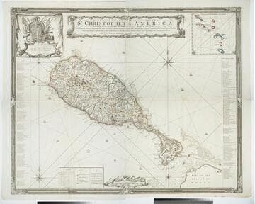
A New and Exact Map of the Island of St. Christopher in America
Visual Materials
One map on four sheets. Cartouche: Vined columns. Jams. Mynde Sculp. Dedication: Military decorations. Table: An Alphabetical List of the Subscribers Names. Submap: The Leeward Caribee Islands. Table of areas of each Parish.. "According to an Actual and Accurate Survey made in the Year 1753. Describing the several Parishes with their respective limits, Contents, & Churches, also the high ways, the Situation of every Gentleman's Plantation, Mills and Houses; with the Rivers, and Gutts. Likewise the Bays, Roads, Rocks, Shoals and Soundings that Surround the Whole. By Saml. Baker Lieutenant in His Majesty's Navy." "To the Right Honble. The Lords Commissioners for Executing the Office of Lord High Admiral of Great Britain &c. This map is most humbly Dedicated By their Lordships most Obedient humble Servt. Saml. Baker." Relief: pictorial. Graphic Scale: Miles. Projection: Plane. Printing Process: Copper engraving. Verso Text: MS notes: 7, 8, 9, 10 778 four sheets.
105:778 M
Image not available
New Map of America, from the latest Observations, revis'd by J. Senex
Visual Materials
Kashnor notes, "A map which shows an unusually accurate knowledge of the North-West Coast at that time. Although California is represented as an Island, there are two groups of islands which are in the locality of Vancouver and Q. Charlotte Islands, and the coastline extends to the Arctic regions, with a place called Desolation in the part now Alaska. In the same locality are represented great forests, and below are two great lakes which, from their position, may probably be the Great and Lesser Slave Lakes." Kashnor notes date as [1719], confirmed by McLaughlin, who also notes New General Atlas, 1721. Cartouche shows natives with feathered headdress and as cannibals.. Prime meridian: London. Relief: pictorial. Graphic Scale: No. Projection: Pseudocylindrical. Printing Process: Copper engraving. Other Features: Cartouche. References: McLaughlin 193; Wagner 520; Tooley 81; Leigthly 155.. Verso Text: MS. note: 45.
093:045 M