Visual Materials
The Seat of the War in the West Indies, or the Islands of America in the North Sea

You might also be interested in

A Map of the West-Indies or the Islands of America in the North Sea
Visual Materials
Kashnor notes, "The map also shows parts of Louisiana and South Carolina, and Central America. It is dedicated to William Paterson, the promoter of the Darien Colony." Kashnor dates as ca. 1720. View of Mexico City. Five submaps. See also 105:328M for another copy. View of Mexico City with building key; Submaps: St. Augustine; Vera Cruz; Havana; Darien; Cartagena.. "with the adjacent Countries; explaning [sic] what belongs to Spain, England, France, Holland &c. also the Trade Winds, and the several Tracts [sic] made by the Galeons [sic] and Flota from place to place. According to the Newest and most Exact Observations by Herman Moll Geographer." "To Wil. Paterson Esq; This map of the West-Indies &c. is most Humbly Dedicated by Herman Moll Geographer." Prime meridian: London. Relief: pictorial. Graphic Scale: Miles, leagues. Projection: Pseudocylindrical. Printing Process: Copper engraving. Other Features: VignettesSub-maps. Verso Text: MS notes: 958.
105:958 M

A New Map of the West Indies; or the Islands of America in the North Sea
Visual Materials
Kashnor notes, :Shows the coast of present-day Texas, and locates the Acansa and Teaucas Land, 'The People about this river are continually in Wars with the Spaniards'." Four harbor submaps. Submaps: A Draught of the Bay & City of Havana; The Bay of Porto Bella; A Draught of the Sity of Cartogena, its Harbour & Forts; La Vara Cruz. Cartouche: Soldiers, battle.. " With the Adjacent Parts, Explaining what belongs to England, Holland, Spain, France, &c. Also the Several Tracts made by the Gallions and Flota. by N. Vischer of Amsterdam. Is now done into English with many Considerable improvements according to the Newest and Best Observations." Prime meridian: Ferro. Relief: pictorial. Graphic Scale: Miles, leagues. Projection: Cylindrical. Printing Process: Copper engraving. Other Features: Sub-mapsCartouche.
105:800 M
Image not available
North America and the West Indies;
Visual Materials
Kashnor notes, "An exceedingly rare map, shoWing the country West of the Mississippi, the boundaries of Virginia, North and South Carolina, reaching to that river. The inset map of the country locates Old Forts EdWard, William Henry, Frederic, St. John, and Chamilles to the St. LaWrence, and Albany, Schenectadi, Forts Hunter and OsWego to Lake Ontario." Kashnor dates as ca. 1764. Submaps and treaty articles. See 093:532 for another copy. "a NeWMap, Wherein the British Empire and its limits, according to the difinitive (sic) Treaty of Peace in 1763, are accurately described, and the Dominions possessed by the Spaniards, the French and other European States; the Whole compiled from the NeWSurveys and Authentic Memoirs that have hitherto appeared. " Cartouche With Natives. Submaps: Particular Map of Baffin and Hudson's Bay; Map of the Country betWeen Montreal, Albany and OsWego. Paper sale tag, June 7, 1927 With MS note: #669.. Prime meridian: London, Ferro. Relief: pictorial. Graphic Scale: Miles, Leagues. Projection: Pseudocylindrical. Printing Process: Copper engraving. Other Features: CartoucheSub-mapsFigures .
105:669 M
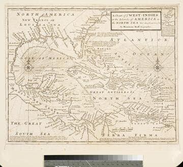
Chart of the West Indies or the Islands of America in the North Sea &c. Being the Present Seat of War. by Herman Moll Geographer
Visual Materials
Kashnor notes, "Shows the mainland around the Gulf of Mexico, with Louisiana, Florida, Georgia, and Carolina." Kashnor dates as ca. 1719. Submap: Vera Cruz harbor. Sailing instructions for galleons. MS note: 321 (on backing). Prime meridian: London. Relief: no. Projection: Cylindrical. Watermark: Two devices. Printing Process: Copper engraving. Other Features: Sub-maps.
105:321 S
Image not available
Chart of the Atlantic Ocean, with the British, French & Spanish Settlements in North America and the West Indies; and also on the Coast of Africa / by Thos. Jeffreys Geographer to His Majesty
Rare Books
This may be Jefferys' copy of John Green's map. It has two overlays, Plate 1 is "Claims of the French in 1756 are colored in yellow." Plate II is "The French Dominions as proposed by M. de Bussy in 1761 are colored yellow and the lands proposed by M. de Bussy to be neutral are colored Green." The main map is designated as Plate III. "The Dominions ceded by France & Spain to Great Britain in 1762 are colored with a feint Red..." Prime meridian: London, Ferro. Relief: no. Projection: Cylindrical. Printing Process: Copper engraving. MS note: Published Feb. 7 1763.
295814
![Chart of the West-Indies or the Islands of America in the North Sea &c. [Being the Present Seat of War] (probably added by Bowles) by Herman Moll Geographer](/_next/image?url=https%3A%2F%2Frail.huntington.org%2FIIIF3%2FImage%2F22APN4KV8V8V%2Ffull%2F%5E360%2C%2F0%2Fdefault.jpg&w=750&q=75)
Chart of the West-Indies or the Islands of America in the North Sea &c. [Being the Present Seat of War] (probably added by Bowles) by Herman Moll Geographer
Visual Materials
Kashnor notes, "A re-issue of Moll's map at the time of Vernon's expedition. Bowles appears to have secured possession of all of Moll's plates." Kashnor dates as ca. 1740. MS notes: 714 (upper left and on backing). Submap: La Vera Cruz.. Prime meridian: London. Relief: no. Projection: Cylindrical. Printing Process: Copper engraving. Other Features: Sub-maps.
093:714 S