Rare Books
A new and general map of the middle dominions belonging to the United States of America, viz. Virginia, Maryland, the Delaware-Counties, Pennsylvania, New Jersey &c. with the addition of New-York, & of the greatest part of New England &c. as also of the bordering parts of the British possessions in Canada

You might also be interested in

A new and general map of the middle dominions belonging to the United States of America, viz. Virginia, Maryland, the Delaware-Counties, Pennsylvania, New Jersey &c. with the addition of New-York, & of the greatest part of New England &c. as also of the bordering parts of the British possessions in Canada. London: Published by Laurie & Whittle, No. 53 Fleet Street, as the Act Directs, 12th May, 1794
Rare Books
The Kitchin map resurfaces after 18 years. Evans and Pownall are gone from the map surface. A dotted line indicates the boundary with Canada. The submap is renamed, new "State of Vermont" is added, as is "Kentucky", but north of the Ohio River. "Province of Quebec" remains, still into US territory. Submap: A sketch of the Upper Parts to show the Remainder of the Lakes, MS note: 18229. Prime meridian: London, Philadelphia. Relief: pictorial. Graphic Scale: Miles. Projection: Pseudocylindrical. Printing Process: Copper engraving. Verso Text: Stamped: XVIII. MS notes: Shelve with #18212 Evans, Lewis ; #18229.
18229

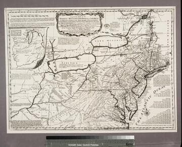
A general map of the middle British Colonies, in America. containing Virginia, Maryland, the Delaware Counties, Pennsylvania and New Jersey. With the addition of New-York and of the greatest part of New England, as also of the bordering parts of the Province of Quebec, improved from several surveys made after the late war, by officers in his Majesty's Service
Rare Books
Sayer & Bennett's reissue of the Kitchin-Jefferys-Sayer and Jefferys plate withdrawn in 1776 from the "American Atlas" reappears in altered form. Sayer & Bennett included this map in "The American Military Pocket Atlas" of 1776 with a dedication to Pownall indicating his probable approval of the map as revised (see 18226 for confirmation). New title added above the original, "The Seat of the War in the Middle British Colonies, containing Virginia, Maryland, The Delaware Counties, &c." Shapes of Lakes Ontario and Erie, the course of the Ohio River are revised, and "Province of Quebec" in large letters is added. The submap is expanded northward and renamed "A sketch of the upper parts of Canada." Submap: A sketch of the upper parts of Canada. MS note: 18225. Prime meridian: London, Philadelphia. Relief: pictorial. Graphic Scale: Miles. Projection: Pseudocylindrical. Printing Process: Copper engraving. Verso Text: Stamped: XIV. MS notes: Shelve with #18212 Evans, Lewis ; #18225.
18225

A general map of the middle British Colonies, in America : containing Virginia, Maryland, the Delaware Counties, Pennsylvania and New Jersey ; with the addition of NewYork and of the greatest part of New England, as also of the bordering parts of the Province of Quebec, improved from several surveys made after the late war, and corrected from Governor Pownall's late map of 1776
Rare Books
A second reissue of the Kitchin-Jefferys-Sayer and Jefferys plate. Few alterations from 18225 issued earlier the same year. Lake Ontario drops the alternate designation as Cadarakui, Falls of Ohio deleted. Issued in later editions of "American Military Pocket Atlas" as map No. 4. Submap: A sketch of the upper parts of Canada. MS note: 18226. Prime meridian: London, Philadelphia. Relief: pictorial. Graphic Scale: Miles. Projection: Pseudocylindrical. Printing Process: Copper engraving. Verso Text: Stamped: XV. MS notes: Shelve with #18212 Evans, Lewis ; #18226.
18226

A general map of the middle British Colonies, in America : viz. Virginia, Maryland, Delaware, Pensilvania, New-Jersey, New York, Connecticut & Rhode Island ; of Aquanishuonigy, the country of the Confederate Indians comprehending Aquanishuonigy proper, their places of residence, Ohio & Thuchsochruntie their deer-hunting countries, Couchsachrage and Skaniadarade, their beaver-hunting countries ; of the Lakes Erie, Ontario and Champlain ; wherein is also shewn the antient & present seats of the Indian Nations ; carefully copied from the original publish'd at Philadelphia / by Mr. Lewis Evans
Visual Materials
Kashnor notes, "This is the eighth issue of Lewis Evans' map. The territory of Ohio is named above and below the river, with the inset showing the remaining parts of Ohio." Many notes on Indian tribes. Prime meridian: London, Philadelphia. Relief: pictorial. Graphic Scale: Miles. Projection: Pseudocylindrical. Printing Process: Copper engraving. Verso Text: MS notes: 3 A General Map of Middle British Colonies in America. Map of the Lakes & Middle Colonies by Evans.
093:526 M

A map of Pensilvania, New-Jersey, New-York, and the three Delaware Counties / by Lewis Evans
Rare Books
This is the earliest known Evans map. See Henry N. Stevens' Third Edition of "Lewis Evans, His Map of the Middle British Colonies in America..." London, 1924, Huntington GA407 E9 S82. This volume also contain the Second Edition of Stevens' work printed in 1920, and a facsimile of a reprint of Evans' map done in 1752 with numerous corrections, known here as 18212a. Views of that map are of Steven's reproduction. Governor Pownall in his "Topographical Description of North America," 1776, notes Evans' 1749 map as "printed at Philadelphia 1749." For the 1752 edition of this map, see RB 53261. Distance table. MS note: 18212. Prime meridian: London, Philadelphia. Relief: pictorial. Graphic Scale: Miles. Projection: Pseudocylindrical. Printing Process: Copper engraving. Verso Text: Stamped: I. MS notes: A 1749 X flat Evans, Lewis - 18212 ; In case with this are: 18213-30, 18193-5.
18212
A general map of the middle British Colonies, in America : viz Virginia, Maryland, Delaware, Pensilvania, New-Jersey, New-York, Connecticut, and Rhode Island ; of Aquanishuonigy the country of the Confederate Indians, comprehending Aquanishuonigy proper, their places of residence, Ohio and Thuchsochruntie their deer hunting countries, Couchsahrage and Skaniadarade, their beaver-hunting countries ; of the Lakes Erie, Ontario and Champlain, and of part of New-France ; wherein is also shewn the antient and present seats of the Indian Nations ; carefully copied from the original publish'd at Philadelphia / by Mr. Lewis Evans 1755, with some improvements by I. Gibson
Rare Books
Reproduction. This appears to be the earliest plagiarism of Evans map. Kitchin made a new plate incorporating Evans' map but eliminating the dedication and replacing it with words from Evans' Analysis (see Preface). Several other statements are also lifted from that source, but in some cases abridged, to show the French as usurpers of British territory. This appears to be the only photo-reproduction in this set of maps, the rest being original copper plate engravings. Note slightly wider but also shorter than 18213. Pownall in his later discussion thought this variant was first done by Thomas Jefferys and criticized the haphazard mountains and poorer engraving. See 18215 by Jefferys from same plate. Submap: A sketch of the Remaining part of the Ohio R., &c. MS note: 18214 Stamp: British Museum, 6 April 1892. Prime meridian: London, Philadelphia. Relief: pictorial. Graphic Scale: Miles. Projection: Pseudocylindrical. Printing Process: Photographic reproduction. Verso Text: Stamped: III. MS notes: Shelve with #18212 Evans, Lewis ; #18214.
18214