Visual Materials
Map of the most Inhabited part of New England containing the Provinces of Massachusets Bay and New Hampshire, with the Colonies of Conecticut and Rhode Island, Divided into Counties and Townships: The whole composed from Actual Surveys and its situation adjusted by Astronomical Observations
You might also be interested in
Image not available
A map of the most inhabited part of New England : containing the provinces of Massachusets Bay and New Hampshire ; with the colonies of Conecticut [sic] and Rhode Island ; divided into counties and townships ; the whole composed from actual surveys and its situation adjusted by astronomical observations
Rare Books
A large map in two sheets. Submaps: A Plan of the Town of Boston; Boston Harbor. Cartouche: Settlers & Indian. Prime meridian: Ferro. Relief: pictorial. Graphic Scale: Miles, leagues. Projection: Cylindrical. Printing Process: Copper engraving. Verso Text: MS notes: New England circled 3; circled 4; 480570 (1 of 2); (2 of 2).
480570
![Map of the most Inhabited part of New England, containing the Provinces of Massachusets [sic] Bay and New Hampshire, with the Colonies of Conecticut [sic] and Rhode Island, Divided into Counties and Townships:](/_next/image?url=https%3A%2F%2Frail.huntington.org%2FIIIF3%2FImage%2F22APN4KVPPAA%2Ffull%2F%5E360%2C%2F0%2Fdefault.jpg&w=750&q=75)
Map of the most Inhabited part of New England, containing the Provinces of Massachusets [sic] Bay and New Hampshire, with the Colonies of Conecticut [sic] and Rhode Island, Divided into Counties and Townships:
Visual Materials
Maine is shown as the Eastern Part of Massachusets. This map derived from Thomas Jeffery's map of 1765. Prime meridian: Ferro. Relief: pictorial. Graphic Scale: Miles, leagues. Projection: Cylindrical. Watermark: Crowned fleur-di-lis JWhatman. Printing Process: Copper engraving. References: McCorkle 771.4.
105:108 M
Image not available
A map of the most inhabited part of New England : containing the provinces of Massachusets Bay and New Hampshire ; with the colonies of Conecticut and Rhode Island
Rare Books
A large four sheet map. English title in upper left hand corner inside an elaborate cartouche; Latin title one third of the way down the map in a simple box. Submaps: Boston. Boston Harbor. Cartouche: Elaborate with figures. "Divided into Counties and Townships The whole composed of Actual Surveys and its situation adjusted by Astronomical Observations." Prime meridian: Ferro. Relief: pictorial. Graphic Scale: Miles. Projection: Pseudocylindrical. Watermark: FCS. Printing Process: Copper engraving. Verso Text: MS notes: 152150 (sheet --}.
152150

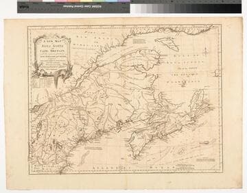
A New Map of Nova Scotia and Cape Britain. with the adjacent parts of New England and Canada, Composed from a great number of actual Surveys ; and other materials Regulated by many new Astronomical Observations of the Longitude as well as Latitude ; with an Explanation
Visual Materials
Kashnor notes, "The first issue of Jefferys' map. It was re-issued twenty years later by Sayer and Bennett." Kershaw states this is the second state of Jefferys map. Prime meridian: London, Ferro. Relief: pictorial. Graphic Scale: Miles, leagues. Projection: Pseudocylindrical. Watermark: I Ville Ary under IHS Crowned fleur-di-lis over LVC. Printing Process: Copper engraving. Other Features: Cartouche. References: Kershaw 739; McCorkle 755.20. Verso Text: MS note: 668.
105:668 M
Image not available
Map of the Coast of New England, from Staten Island to the Island of Cape Breton as it was actually surveyed by Capt. Cyprian Southack
Visual Materials
Kashnor notes, "A very good copy of a very rare map. The map of Boston may have been taken from the Bonner Map of 1722, but it is probable that Southack made a new survey. It is the third printed plan of Boston." Kashnor dates as ca. 1740. McCorkle identifies this as a later edition of the 1735 original map. Submaps: Town of Boston in New England; Chart of the Atlantic Ocean showing the situation of Nova Scotia with respect to the British Isles.. Prime meridian: London. Relief: pictorial. Graphic Scale: Miles. Projection: Mercator. Watermark: Fleur-di-lis. Printing Process: Copper engraving. Other Features: Sub-maps. References: McCorkle 735.1. Verso Text: MS notes: 532 East end of Georges Bank from Cape St. Mary to SSW distance 115 miles..
105:532 M
![Seat of the War, in New England, by an American Volunteer [Submap]: Plan of the Town of Boston with the Attack on Bunkers-Hill in the Peninsula of Charlestown, the 17th. of June 1775. With the Marches of the Several Corps Sent by the Colonies. Towards Boston. with the Attack on Bunkers = Hill](/_next/image?url=https%3A%2F%2Frail.huntington.org%2FIIIF3%2FImage%2F22APN4KOYJI7%2Ffull%2F%5E360%2C%2F0%2Fdefault.jpg&w=750&q=75)
Seat of the War, in New England, by an American Volunteer [Submap]: Plan of the Town of Boston with the Attack on Bunkers-Hill in the Peninsula of Charlestown, the 17th. of June 1775. With the Marches of the Several Corps Sent by the Colonies. Towards Boston. with the Attack on Bunkers = Hill
Visual Materials
Kashnor notes, "A very fine and rare war plan, with both imprints. The Bunker's Hill plan shows Charlestown in flames." Two submaps: Plan of Boston Harbour from an Actual Survey. Plan of the Town of Boston.... Prime meridian: London. Relief: hachures. Graphic Scale: Miles, English. Projection: Cylindrical. Watermark: Crowned fluer-di-lis (half). Printing Process: Copper engraving. Other Features: Sub-maps. References: McCorkle 775.1. Verso Text: MS note: 128.
093:128 M