Visual Materials
Map of the most Inhabited part of New England, containing the Provinces of Massachusets [sic] Bay and New Hampshire, with the Colonies of Conecticut [sic] and Rhode Island, Divided into Counties and Townships:
You might also be interested in

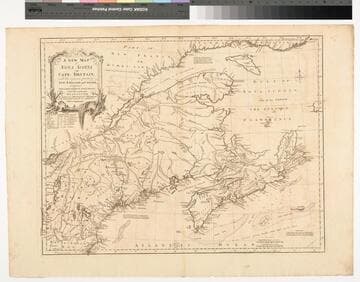
A New Map of Nova Scotia and Cape Britain. with the adjacent parts of New England and Canada, Composed from a great number of actual Surveys ; and other materials Regulated by many new Astronomical Observations of the Longitude as well as Latitude ; with an Explanation
Visual Materials
Kashnor notes, "The first issue of Jefferys' map. It was re-issued twenty years later by Sayer and Bennett." Kershaw states this is the second state of Jefferys map. Prime meridian: London, Ferro. Relief: pictorial. Graphic Scale: Miles, leagues. Projection: Pseudocylindrical. Watermark: I Ville Ary under IHS Crowned fleur-di-lis over LVC. Printing Process: Copper engraving. Other Features: Cartouche. References: Kershaw 739; McCorkle 755.20. Verso Text: MS note: 668.
105:668 M

Bowles's New Pocket-Map of North America, divided into it's Provinces, Colonies, &c. by J. Palairet, Geographer; lately revised and improved with many additions, from D'Anville, Mitchel, & Bellin, by L. Delarochette
Visual Materials
Kashnor notes, "Shows the Californian coast north to Jaun de Fuca Strait, locating New Albion and Sr. Francis Drake's Harbour. The map was issued during the early part of the American Revolution." Kashnor dates as c. 1776. Shows River of the West and possible connection to the Missouri. Table of land division between nations.. Prime meridian: Ferro. Relief: pictorial. Graphic Scale: Miles, leagues, paces. Projection: Pseudocylindrical. Watermark: Crowned fleur-di-lis J. Whatman. Printing Process: Copper engraving. Verso Text: MS note: 212.
105:212 M
Image not available
2e. Carte de l'Asia. 1755
Visual Materials
Kashnor notes, "This is Palairet's map. It shows the Philippine Islands." MS note: 9 (upper right). Prime meridian: Ferro. Relief: pictorial. Graphic Scale: Miles, leagues, wersts, parasanges.. Projection: Azimuthal. Watermark: Crowned fleur-di-lis VI. Printing Process: Copper engraving. Verso Text: MS notes: 741 9.
105:741 M
Image not available
Land-Kaart van het Eiland en de Volksplanting van Cayenne aan de Kust van Zuid-Amerika
Visual Materials
Kashnor dates as [Amsterdam ca. 1750]. This map may derive from Jeffery's 1760 maps, see 093:659 and 660. This map is made to the same scale as the Jeffery's map. Submap: Platte Grond van de Stad en 't Kasteel van Cayenne.. Prime meridian: Ferro. Relief: hachures. Graphic Scale: Leagues. Projection: Cylindrical. Watermark: Crowned fleur-di-lis VI. Printing Process: Copper engraving. Other Features: Sub-maps. Verso Text: MS note: 661.
093:661 S
Image not available
A New and Correct Map of North America with the West India Islands, divided According to the Last Treaty of Peace concluded at Paris 10th Feby.1763, wherein are particularly Distinguished The Several Provinces and Colonies which compose the British Empire, Laid down according to the latest Surveys, and Corrected from the Original Materials, of Govrnr. Pownall, Membr. of Parliamt. 1777
Visual Materials
Insert maps of Baffin's and Hudson's Bays, copy of Kino's map. For a later version (1794) see 105:269M and also 093:218M (1786) and 093:199 a variation. Cartouche w. alligator. Text of Articles 4 through 9, 17, 18 and 20 of Treaty of 1763. Submap: A Particular Map of Baffin & Hudson's Bay. A Passage by Land to California.. Prime meridian: Ferro. Relief: pictorial. Graphic Scale: Miles, leagues. Projection: Pseudocylindrical. Watermark: WF RG Crowned fleur di lis. Printing Process: Copper engraving. Other Features: CartoucheSub-maps. Verso Text: 30 MS notes: 445 Pownall N. America .
105:445 M

Martinico, Done from Actual Surveys and Observations, made by English Engineers whilst the Island was in their Possession, by Thomas Jefferys Geographer to the King
Visual Materials
Submap: Cul de Sac Royal. "VIII (upper right)" Prime meridian: Ferro. Relief: hachures. Graphic Scale: Leagues. Projection: Plane. Watermark: Crowned fleur-di-lis VI. Printing Process: Copper engraving. Other Features: Sub-maps. Verso Text: MS notes: 507 16.
105:507 M