Visual Materials
Map of the Coast of New England, from Staten Island to the Island of Cape Breton as it was actually surveyed by Capt. Cyprian Southack
You might also be interested in
Image not available
Map of Nova Scotia or Acadia; with the Islands of Cape Breton and St. John's, from Actual Surveys by Capt. Montresor, Engr. 1768
Visual Materials
Kashnor notes, "A rare map. Dedicated to John Manners, Marquis of Granby, with emblematic engravings, trophies, etc. A very fine topographical map, indicating the parishes in St. John's, hills, rivers, soundings, sandbanks, &c." Kershaw identifies as the second state, supplies appeared in information. Elaborate dedication cartouche.. "To the Most Noble John Manners Marquis of Granby, Field Marshall & Commander in Chief of all His Majesty's Forces Master General of Ordnance, Colonel of His Majesty's Royal Regimt. of Horse Guards Blue, Honourable Privy Council: This Map with all Submission is most humbly inscribed by Your Lordship's most dutiful most obedient and devoted Servant John Montresor, Engineer." "J. Caldnall Sculp." Prime meridian: Ferro9. Relief: pictorial. Graphic Scale: Miles. Projection: Plane. Printing Process: Copper engraving. Other Features: Cartouche. References: Kershaw 793. Verso Text: MS notes: 610 10.
105:610 M
Image not available
The Town of Boston in New England / by Capt. John Bonner 1722
Rare Books
An 1835 copy of a 1722 map of Boston. "Engraved and printed by Fra. Dening, Boston NE 1722. Sold by Capt. John Bonner and Willm. Price against the town house where may be had all Sorts of Prints & Mapps &c." Printed MS note: I have examined this plan and find it to be an exact copy of the original Stephen P. Fuller, Surveyor, Boston, July 2, 1835. Relief: pictorial. Graphic Scale: Miles. Projection: Cylindrical. Printing Process: Copper engraving.
194177
Image not available
A New Map of New England. New York. New Jarsey. Pensilvania. Maryland. and Virginia. by Philip Lea in Cheap-side London
Visual Materials
Kashnor notes: "An exceedingly rare map locating as far up the Hudson River as New Albanie; locates Fort Elsinborough on the Delaware, and takes in the coast from Cape Henry to Boston." McCorkle states this is a later state of Lea's 1680 map, which the British Library says is from 1686, similar to Kashnor's dating. Kashnor dates as ca. 1686. Atlantic Ocean is named "Sea of the English Empire." Submap: Entry to New York Harbor.. Relief: pictorial. Graphic Scale: Miles. Projection: Cylindrical. Watermark: II. Printing Process: Copper engraving. Other Features: Sub-maps. References: McCorkle 680.4. Verso Text: MS notes: 105/582.
105:582 M
Image not available
Map of the most Inhabited part of New England containing the Provinces of Massachusets Bay and New Hampshire, with the Colonies of Conecticut and Rhode Island, Divided into Counties and Townships: The whole composed from Actual Surveys and its situation adjusted by Astronomical Observations
Visual Materials
Kashnor notes, "This is the old Colonial Map, originally engraved and issued by Thomas Jefferys, the plate having passed into the possession of the firm when the Jefferys and Sayer, and Sayer and Bennett firms became Laurie and Whittle." Two submaps. Patterned after Jeffreys' 1755 map, see McCorkle 755.19. Cartouche: Landing of the Mayflower at Plymouth. Submaps: Plan of the Town of Boston; Plan of Boston Harbor from an Accurate Survey.. Prime meridian: London. Relief: pictorial. Graphic Scale: Miles, leagues. Projection: Cylindrical. Printing Process: Copper engraving. Other Features: Sub-mapsCartouche. References: McCorkle 755.19.. Verso Text: MS notes: 457 England 4 Sheets (one sheet)..
093:457 M

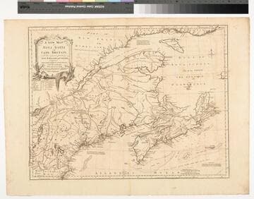
A New Map of Nova Scotia and Cape Britain. with the adjacent parts of New England and Canada, Composed from a great number of actual Surveys ; and other materials Regulated by many new Astronomical Observations of the Longitude as well as Latitude ; with an Explanation
Visual Materials
Kashnor notes, "The first issue of Jefferys' map. It was re-issued twenty years later by Sayer and Bennett." Kershaw states this is the second state of Jefferys map. Prime meridian: London, Ferro. Relief: pictorial. Graphic Scale: Miles, leagues. Projection: Pseudocylindrical. Watermark: I Ville Ary under IHS Crowned fleur-di-lis over LVC. Printing Process: Copper engraving. Other Features: Cartouche. References: Kershaw 739; McCorkle 755.20. Verso Text: MS note: 668.
105:668 M

Map of the Inhabited Part of Canada from the French Surveys With the Frontiers of NeW York and NeW England from the Large Survey by Claude Joseph Sauthier
Visual Materials
Kashnor notes, " With engraved locations of the 'Winter Quarters of the King's Army in Canada, 1776' and shoWing the old locations of the land grants around Lake Champlain and doWn to Lake George, made after the Old French War, a very rare map." see 105-305M for a variant copy. Elaborate cartouche of traders dealing With Indians for pelts. Includes "Winter quarters of the King's Army in Canada, 1776.". Relief: pictorial & hachures. Graphic Scale: Miles, statute, leagues, Canadian. Projection: Cylindrical. Watermark: J WHATMAN. Printing Process: Copper engraving. Other Features: Cartouche. References: McCorkle 777.19. Verso Text: MS note: 72.
105:072 M