Manuscripts
Map showing areas of lands now owned by E. L. Mayberry / surveyed by Wright & Nicholson

You might also be interested in
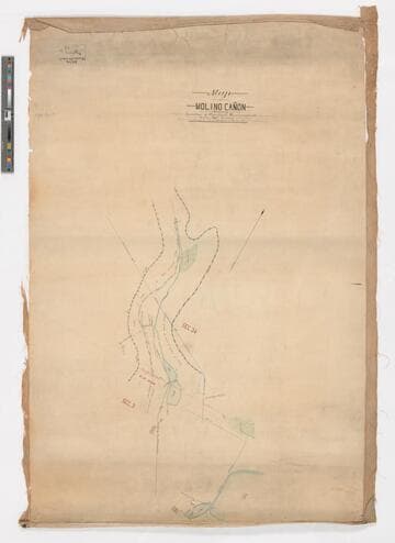
Map of Molino Cañon showing location of pipelines, reservoirs, etc. / surveyed by Fred Eaton
Manuscripts
Depicts the dams, pipelines, reservoirs, and fences surrounding the property. Color. One of three hand-drawn survey maps representing a San Marino, California property as purchased and developed by Edward L. Mayberry (1834-1902) between 1880 and 1900. One of the two maps used as evidence in an 1895 lawsuit over water rights between Mayberry and the Alhambra Addition Water Company. The other map used in the lawsuit is mssHM 83404c, dated 1894. The three maps document the remnants of the Molino Canyon mission water system, agricultural activity in San Marino before 20th-century residential subdividing, and evidence of the area before Henry Huntington purchased a large portion of it.
mssHM 83404b
Image not available
Three 19th-century maps of San Marino, California, showing local water routes, especially El Molino (now Kewen) Canyon
Manuscripts
Three hand-drawn survey maps representing a San Marino, California property as purchased and developed by Edward L. Mayberry (1834-1902) between 1880 and 1900. Two of the maps (dated 1887 and 1894) were used as evidence in an 1895 lawsuit over water rights between Mayberry and the Alhambra Addition Water Company. The three maps document the remnants of the Molino Canyon mission water system, agricultural activity in San Marino before 20th-century residential subdividing, and evidence of the area before Henry Huntington purchased a large portion of it.
mssHM 83404a-c

Map of Rancho El Molino, the property of J. E. Hollenbeck / surveyed by A. G. Ruxton
Manuscripts
Depicts the 320 acres bounded by the Wilson estate, and the properties of Richardson and H. D. Barrows. Also included are the former owners of lots and years of transfer (i.e. Wilson to Kewen, Nov. 27, 1871; E. J. C. Kewen to T. W. Temple, June 1875, etc.). One of three hand-drawn survey maps representing a San Marino, California property as purchased and developed by Edward L. Mayberry (1834-1902) between 1880 and 1900. Two of the maps (mssHM 83404b, dated 1887, and mssHM 83404c, 1894) were used as evidence in an 1895 lawsuit over water rights between Mayberry and the Alhambra Addition Water Company. The three maps document the remnants of the Molino Canyon mission water system, agricultural activity in San Marino before 20th-century residential subdividing, and evidence of the area before Henry Huntington purchased a large portion of it.
mssHM 83404a
Image not available
Maps of San Gabriel Mission lands
Manuscripts
HM 79258 - Mimeographed map: "Mission San Gabriel...showing the irregular Tracts of cultivated Land within Section 11..." (1870, May). Surveyed by H. M. Johnston (71 x 55 cm.).
mssHM 79258-79259
Image not available
Map of land owned by R. Simon in Alameda County, California
Manuscripts
Map of land owned by R. Simon, part of the A.M. Peralta portion of the San Antonio Rancho, Alameda County, California. Surveyed by L. Castro in July 1885.
mssHM 84249

Big Creek area map with layers showing water courses topographic contours and hydro facilities
Visual Materials
[Big Creek area map with layers showing water courses topographic contours and hydro facilities. Map is mislabeled in a few areas (Lake Edison and Florence Lake are reversed, Mono/Bear diversion location is incorrect.] [with 3 variants]
photCL SCE 06 - 73015