Manuscripts
Map of Rancho El Molino, the property of J. E. Hollenbeck / surveyed by A. G. Ruxton

You might also be interested in
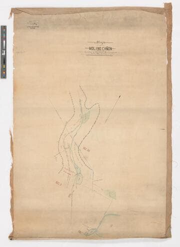
Map of Molino Cañon showing location of pipelines, reservoirs, etc. / surveyed by Fred Eaton
Manuscripts
Depicts the dams, pipelines, reservoirs, and fences surrounding the property. Color. One of three hand-drawn survey maps representing a San Marino, California property as purchased and developed by Edward L. Mayberry (1834-1902) between 1880 and 1900. One of the two maps used as evidence in an 1895 lawsuit over water rights between Mayberry and the Alhambra Addition Water Company. The other map used in the lawsuit is mssHM 83404c, dated 1894. The three maps document the remnants of the Molino Canyon mission water system, agricultural activity in San Marino before 20th-century residential subdividing, and evidence of the area before Henry Huntington purchased a large portion of it.
mssHM 83404b
Image not available
Three 19th-century maps of San Marino, California, showing local water routes, especially El Molino (now Kewen) Canyon
Manuscripts
Three hand-drawn survey maps representing a San Marino, California property as purchased and developed by Edward L. Mayberry (1834-1902) between 1880 and 1900. Two of the maps (dated 1887 and 1894) were used as evidence in an 1895 lawsuit over water rights between Mayberry and the Alhambra Addition Water Company. The three maps document the remnants of the Molino Canyon mission water system, agricultural activity in San Marino before 20th-century residential subdividing, and evidence of the area before Henry Huntington purchased a large portion of it.
mssHM 83404a-c
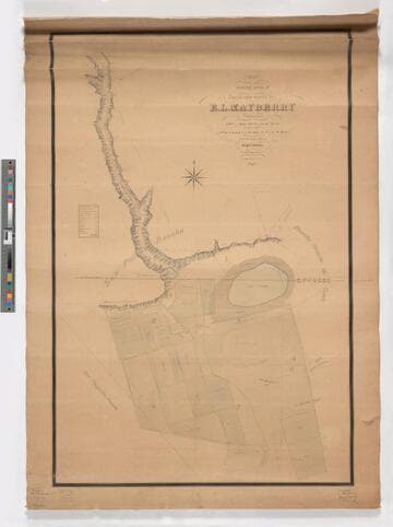
Map showing areas of lands now owned by E. L. Mayberry / surveyed by Wright & Nicholson
Manuscripts
Depicts Mayberry's lots bounded by the San Pasqual Rancho, Rancho Huerta de Cuati, and Pasqualito Rancho with a focus on the water source of the Cañada de Molino (or El Molino Canyon, now called Kewen Canyon), the location of wells, a reservoir, and Lake Vineyard. The map contains a key that classifies the amount and type of cultivated acreage contained within Lots 1, 2, 3, 4, 6, 7, and 8 of Mayberry's property. The map also depicts the location of Mayberry's house and the "old mill" (also known as El Molino Viejo) and the location of cultivated land devoted to vines, alfalfa, grain, walnuts, lemons, oranges, grain, pears, and the length of time (in years) of cultivation. One of three hand-drawn survey maps representing a San Marino, California property as purchased and developed by Edward L. Mayberry (1834-1902) between 1880 and 1900. One of the two maps used as evidence in an 1895 lawsuit over water rights between Mayberry and the Alhambra Addition Water Company. The other map used in the lawsuit is mssHM 83404b, dated 1887. The three maps document the remnants of the Molino Canyon mission water system, agricultural activity in San Marino before 20th-century residential subdividing, and evidence of the area before Henry Huntington purchased a large portion of it.
mssHM 83404c

Home of Col. E. J. C. Kewen at El Molino
Visual Materials
View of the back of a large house with an attached small building. Col. E. J. C. Kewen and his wife lived for 20 years in the building known as "El Molino Viejo" (Old Mill) in present-day San Marino. This is not that building, but may be another building on the El Molino ranch property; the exact location is unclear. See notes below.
photCL_555_06_138
Image not available
Survey maps of ranchos San Pablo, El Pinole, Acalanes, San Antonio, Moraga, and San Lorenzo: facsimiles
Manuscripts
A group of facsimiles of eight survey maps of various ranchos in California; accompanying the maps is one printed page of explanation of the survey maps. The maps are pasted down onto brittle, browned paper and some of the maps are quite faded; it appears the pages may have been removed from a bound volume.
mssHM 84108
Image not available
Record of survey of E. G. Luckey property
Manuscripts
Administrative Series contains records relating to various facilitative operations within the Alamitos Land Company, including, but not limit to, account books, annual reports, appraisals, articles of incorporation, audits, balance sheets, bylaws, correspondence, financial records, financial statements, inventories, ledgers, legal documents, minutes, stock certificates, and titles (property rights). This series is organized alphabetically. A small number of oversize administrative records are stored under the Oversize Series. Commercial Properties Series include a wide-ranging type of records relating to the company's commercial and industrial portfolio. As per the original order, records are grouped under the headings of their respective commercial properties or projects, which include, but not limit to, Alamitos Beach Townsites, Alamitos Tract, Bixby Center, Bixby Ridge, Brawley Beef Packing Plant, Brawley Steam Wells, Firebaugh, Geothermal, Hathaway Apartments, Hathaway Business Park, The Knolls, Long Beach Tidelands, Luckey Ranch, Palo Verde and Spring Retail, Paramount Business Park, Recreation Park, Reservoir Hill, Rosemead Flair Business Park, Signal Hill East Unit, Tract 10548, U.S. Navy Depot, and the Willows Office Building. All commercial properties and projects were located within the State of California. This series is organized alphabetically.
mssAlamitos