Manuscripts
Three 19th-century maps of San Marino, California, showing local water routes, especially El Molino (now Kewen) Canyon
You might also be interested in
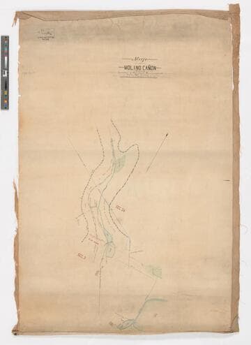
Map of Molino Cañon showing location of pipelines, reservoirs, etc. / surveyed by Fred Eaton
Manuscripts
Depicts the dams, pipelines, reservoirs, and fences surrounding the property. Color. One of three hand-drawn survey maps representing a San Marino, California property as purchased and developed by Edward L. Mayberry (1834-1902) between 1880 and 1900. One of the two maps used as evidence in an 1895 lawsuit over water rights between Mayberry and the Alhambra Addition Water Company. The other map used in the lawsuit is mssHM 83404c, dated 1894. The three maps document the remnants of the Molino Canyon mission water system, agricultural activity in San Marino before 20th-century residential subdividing, and evidence of the area before Henry Huntington purchased a large portion of it.
mssHM 83404b

Map of Rancho El Molino, the property of J. E. Hollenbeck / surveyed by A. G. Ruxton
Manuscripts
Depicts the 320 acres bounded by the Wilson estate, and the properties of Richardson and H. D. Barrows. Also included are the former owners of lots and years of transfer (i.e. Wilson to Kewen, Nov. 27, 1871; E. J. C. Kewen to T. W. Temple, June 1875, etc.). One of three hand-drawn survey maps representing a San Marino, California property as purchased and developed by Edward L. Mayberry (1834-1902) between 1880 and 1900. Two of the maps (mssHM 83404b, dated 1887, and mssHM 83404c, 1894) were used as evidence in an 1895 lawsuit over water rights between Mayberry and the Alhambra Addition Water Company. The three maps document the remnants of the Molino Canyon mission water system, agricultural activity in San Marino before 20th-century residential subdividing, and evidence of the area before Henry Huntington purchased a large portion of it.
mssHM 83404a
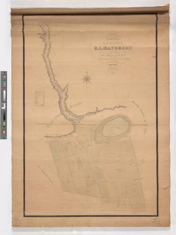
Map showing areas of lands now owned by E. L. Mayberry / surveyed by Wright & Nicholson
Manuscripts
Depicts Mayberry's lots bounded by the San Pasqual Rancho, Rancho Huerta de Cuati, and Pasqualito Rancho with a focus on the water source of the Cañada de Molino (or El Molino Canyon, now called Kewen Canyon), the location of wells, a reservoir, and Lake Vineyard. The map contains a key that classifies the amount and type of cultivated acreage contained within Lots 1, 2, 3, 4, 6, 7, and 8 of Mayberry's property. The map also depicts the location of Mayberry's house and the "old mill" (also known as El Molino Viejo) and the location of cultivated land devoted to vines, alfalfa, grain, walnuts, lemons, oranges, grain, pears, and the length of time (in years) of cultivation. One of three hand-drawn survey maps representing a San Marino, California property as purchased and developed by Edward L. Mayberry (1834-1902) between 1880 and 1900. One of the two maps used as evidence in an 1895 lawsuit over water rights between Mayberry and the Alhambra Addition Water Company. The other map used in the lawsuit is mssHM 83404b, dated 1887. The three maps document the remnants of the Molino Canyon mission water system, agricultural activity in San Marino before 20th-century residential subdividing, and evidence of the area before Henry Huntington purchased a large portion of it.
mssHM 83404c

Home of Col. E. J. C. Kewen at El Molino
Visual Materials
View of the back of a large house with an attached small building. Col. E. J. C. Kewen and his wife lived for 20 years in the building known as "El Molino Viejo" (Old Mill) in present-day San Marino. This is not that building, but may be another building on the El Molino ranch property; the exact location is unclear. See notes below.
photCL_555_06_138
Image not available
19th century Album [material removed]
Manuscripts
The collections consists of 53 letters, poems and other manuscripts written by various members of the Leigh family and other people in their circle. The letters are mainly concerned with the intimate, mundane, playful and tragic aspects of family life from the early modern period until the middle of the 19th century. There is also a small number of poems, written by or copied out by family members, a Hymn, a speech, and a travel account. The collection also contains the 19th century volume, titled in gild on spine "Original Family Papers &c. Vol. 1. MSS." Letters and other material purchased by the Huntington Library Collectors' Council have been removed from the volume by the Huntington Library Conservation Department. An unknown number of letters were removed from the volume prior to the Huntington Library purchase.
mssHM 81608-81660
Image not available
III. 19th century manuscript catalog
Manuscripts
This collection consists of two parts: the records of the Benedictine abbey of St. Martin at Battle, Sussex, dating before 1538, and the papers from 1538 onward, chiefly of the Browne family (1538-1721), Viscounts Montague, who purchased the Battle Abbey properties following the monastery's dissolution, and then the Webster family (1721-1857). The collection is particularly rich in monastic and estate accounts, court records, and deeds for lands possessed by Battle Abbey in Sussex, Berkshire, Essex, Surrey, and Kent. The records prior to 1538 consist of a complete monastic archive, the product of one integrated religious institution. Document types include obedientiary and estate and manorial accounts; court rolls and other court records; deeds and charters; rentals and surveys, with related papers; and miscellaneous papers. The papers created after the dissolution of the monastery consist of two major sub-collections, corresponding to Browne and Webster family papers, as well as of Cheke, Jorden, and Whistler. The bulk of this post-Dissolution material pertain to the Webster family, and deals with legal, financial, and estate matters; there is little correspondence.
mssBA