Manuscripts
Map of Molino Cañon showing location of pipelines, reservoirs, etc. / surveyed by Fred Eaton

You might also be interested in
Image not available
Three 19th-century maps of San Marino, California, showing local water routes, especially El Molino (now Kewen) Canyon
Manuscripts
Three hand-drawn survey maps representing a San Marino, California property as purchased and developed by Edward L. Mayberry (1834-1902) between 1880 and 1900. Two of the maps (dated 1887 and 1894) were used as evidence in an 1895 lawsuit over water rights between Mayberry and the Alhambra Addition Water Company. The three maps document the remnants of the Molino Canyon mission water system, agricultural activity in San Marino before 20th-century residential subdividing, and evidence of the area before Henry Huntington purchased a large portion of it.
mssHM 83404a-c

Map of Rancho El Molino, the property of J. E. Hollenbeck / surveyed by A. G. Ruxton
Manuscripts
Depicts the 320 acres bounded by the Wilson estate, and the properties of Richardson and H. D. Barrows. Also included are the former owners of lots and years of transfer (i.e. Wilson to Kewen, Nov. 27, 1871; E. J. C. Kewen to T. W. Temple, June 1875, etc.). One of three hand-drawn survey maps representing a San Marino, California property as purchased and developed by Edward L. Mayberry (1834-1902) between 1880 and 1900. Two of the maps (mssHM 83404b, dated 1887, and mssHM 83404c, 1894) were used as evidence in an 1895 lawsuit over water rights between Mayberry and the Alhambra Addition Water Company. The three maps document the remnants of the Molino Canyon mission water system, agricultural activity in San Marino before 20th-century residential subdividing, and evidence of the area before Henry Huntington purchased a large portion of it.
mssHM 83404a
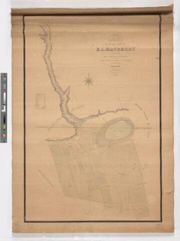
Map showing areas of lands now owned by E. L. Mayberry / surveyed by Wright & Nicholson
Manuscripts
Depicts Mayberry's lots bounded by the San Pasqual Rancho, Rancho Huerta de Cuati, and Pasqualito Rancho with a focus on the water source of the Cañada de Molino (or El Molino Canyon, now called Kewen Canyon), the location of wells, a reservoir, and Lake Vineyard. The map contains a key that classifies the amount and type of cultivated acreage contained within Lots 1, 2, 3, 4, 6, 7, and 8 of Mayberry's property. The map also depicts the location of Mayberry's house and the "old mill" (also known as El Molino Viejo) and the location of cultivated land devoted to vines, alfalfa, grain, walnuts, lemons, oranges, grain, pears, and the length of time (in years) of cultivation. One of three hand-drawn survey maps representing a San Marino, California property as purchased and developed by Edward L. Mayberry (1834-1902) between 1880 and 1900. One of the two maps used as evidence in an 1895 lawsuit over water rights between Mayberry and the Alhambra Addition Water Company. The other map used in the lawsuit is mssHM 83404b, dated 1887. The three maps document the remnants of the Molino Canyon mission water system, agricultural activity in San Marino before 20th-century residential subdividing, and evidence of the area before Henry Huntington purchased a large portion of it.
mssHM 83404c
Image not available
6. Sierra Land and Water Company Map Showing Location of June-Gull Lakes Reservoir, 1922 (1 piece)
Manuscripts
The collection consists of correspondence, documents, maps, reports, publications, and clippings related to land tenure and water use in and around Mono County (including Mono Basin, Mono Lake, Lee Vining Creek and Rush Creek), Inyo County, and Los Angeles, California.
mssClover
Image not available
7. Sierra Land and Water Company Map Showing Location of Silver Lake Reservoir…and Lands to be Irrigated from Said Reservoirs and Canals, [n.d.] (1 piece)
Manuscripts
The collection consists of correspondence, documents, maps, reports, publications, and clippings related to land tenure and water use in and around Mono County (including Mono Basin, Mono Lake, Lee Vining Creek and Rush Creek), Inyo County, and Los Angeles, California.
mssClover
Image not available
8. Sierra Land and Water Company Map Showing Location of Silver Lake Reservoir…and Silver Lake Canal, [n.d.] (1 piece)
Manuscripts
The collection consists of correspondence, documents, maps, reports, publications, and clippings related to land tenure and water use in and around Mono County (including Mono Basin, Mono Lake, Lee Vining Creek and Rush Creek), Inyo County, and Los Angeles, California.
mssClover