Visual Materials
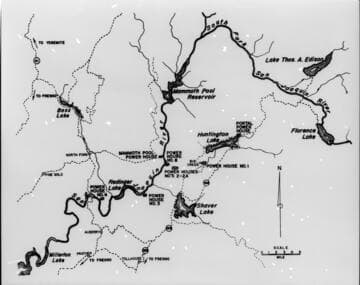
Big Creek area map with layers showing water courses topographic contours and hydro facilities
You might also be interested in

Relief map of Big Creek area
Visual Materials
[Relief map of Big Creek area - Contours, tributaries, and hydroelectric facilities shown.]
photCL SCE 06 - 73017

Map of Big Creek area
Visual Materials
[Map of Big Creek area - reservoirs and powerhouses shown, but not flow-lines, tunnels, or penstocks]
photCL SCE 06 - 73016

Big Creek - Mammoth Pool - Discharge of the diversion tunnel showing low water
Visual Materials
Big Creek - Mammoth Pool - Discharge of the diversion tunnel showing low water.
photCL SCE 06 - 45562
Image not available
Personal album of snapshots showing area around Big Creek
Visual Materials
Personal album of snapshots showing area around Big Creek, including Pittman Falls, Huntington Lake, snow recreation, Dam 4, Nellie Lake, winter scenes, family life , Jerry Dwyer's dog team, Dam 1, Yosemite, and assorted vacation images including automobile touring in the Southwest. There is one photograph of a man standing in the snow with a camera.
photCL SCE

Coyote Lake, Big Creek, Stevenson Creek Falls, Thousand Island Lake; Borel Powerhouse & cottages, Borel interior, Kern Sub., Indian Sub., Newhall Sub.; Azusa Hydro Plant; Sierra Hydro Plant; Mentone Hydro Plant; Redondo Steam Plant
Visual Materials
Coyote Lake (head of Big Creek), Big Creek [cascade above PH1 site], Stevenson Creek Falls, Thousand Island Lake; Borel Powerhouse & cottages, Borel interior [with the original 5 Pelton Waterwheel units], Kern Sub., Indian Sub., Newhall Sub.; Azusa Hydro Plant; Sierra Hydro Plant; Mentone Hydro Plant; Redondo Steam Plant.
photCL SCE 13 - vol 055
Image not available
Big Creek relief map for display
Visual Materials
Big Creek relief map for display - [with 3 variants]
photCL SCE 06 - 71308