Visual Materials
Relief map of Big Creek area

You might also be interested in
Map of Big Creek area
Visual Materials
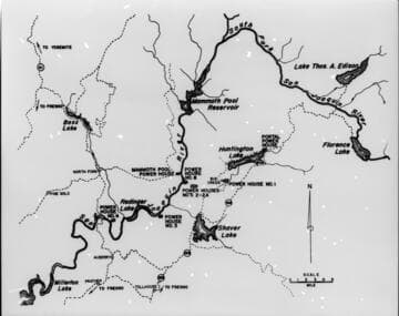
[Map of Big Creek area - reservoirs and powerhouses shown, but not flow-lines, tunnels, or penstocks]
photCL SCE 06 - 73016

Big Creek area map with layers showing water courses topographic contours and hydro facilities
Visual Materials
[Big Creek area map with layers showing water courses topographic contours and hydro facilities. Map is mislabeled in a few areas (Lake Edison and Florence Lake are reversed, Mono/Bear diversion location is incorrect.] [with 3 variants]
photCL SCE 06 - 73015
Image not available
Big Creek relief map for display
Visual Materials
Big Creek relief map for display - [with 3 variants]
photCL SCE 06 - 71308

3D relief map display of Sierra Nevada's and all existing Big Creek facilities
Visual Materials
3D relief map display of Sierra Nevada's and all existing Big Creek facilities.
photCL SCE 05 - 55318

3D relief map display of Sierra Nevada's and all existing Big Creek facilities
Visual Materials
3D relief map display of Sierra Nevada's and all existing Big Creek facilities.
photCL SCE 05 - 55319

Relief Map of the Big Creek System
Visual Materials
Relief Map of the Big Creek System. [with Powerhouse #4 included]
photCL SCE 05 - 54344