Rare Books
Plan of Charlestown from a survey of Edwd. Crisp in 1704
You might also be interested in
Image not available
New and Accurate Map of Virginia & Maryland Laid Down from Surveys and Regulated by Astron'l Observat'ns. By Eman. Bowen
Visual Materials
Kashnor dates as ca. 1750. RLIN record suggests 1792, gives appeared in information. Shadow of text transfer on map surface. MS note: 820 (on backing).. Prime meridian: London. Relief: no. Graphic Scale: Miles. Projection: Cylindrical. Printing Process: Copper engraving. Verso Text: Shadow of text transfer on verso..
105:820 S
Image not available
Plan of Cape Breton, &c Fort Louisbourgh, &c
Visual Materials
Kashnor notes, "A very rare map, issued probably in Boston soon after the taking of Louisbourg by Pepperell." Kershaw suggests Thomas Johnston as map author as does Wheat & Brun. (Wheat and Brun refer to Museum Book Store catalog, this map.) Lower map detail of Louisbourgh defenses and British forces. MS note: 291 (on backing).. Prime meridian: London. Relief: no. Projection: Cylindrical. Watermark: I-ro Pa-- seated figure, sun with face and rays. Printing Process: Copper engraving. Other Features: Sub-maps. References: Kershaw 893; Wheat & Brun 71.. Verso Text: MS note: 291 (on backing)..
093:291 S

Plan of Port Royal in South Carolina Survey'd by Capn. John Gascoigne
Visual Materials
Kashnor notes, "A very rare war map of South Carolina. It shows the different islands, the chief plantations, the soundings of the harbour and rivers, and indicates places of military importance." [Hilton Head Island is named Trench's Island on this map.] See 105:348 for a later version of this map. Sailing directions. Beautifully hand colored.. Prime meridian: London. Relief: no. Graphic Scale: Miles. Projection: Plane. Printing Process: Copper engraving. Verso Text: MS note: 380.
093:380 M
Image not available
A Plan of Port Royal in South Carolina Survey'd by Capn. John Gascoigne
Visual Materials
Kashnor notes, "A very rare war map of South Carolina. It shows the different islands, the chief plantations, the soundings of the harbour and rivers, and indicates places of military importance." [note from 093:380] [Hilton Head Island is named Trench's Island on this map.] See 093:380 for an earlier version of this map. The RLIN record covers an earlier version printed by Jefferys & Faden. Sailing directions.. Prime meridian: London. Relief: no. Graphic Scale: Miles. Projection: Plane. Printing Process: Copper engraving. Verso Text: MS note: 348.
105:348 M

Chart of the Saintes from an Actual Survey
Visual Materials
Some map mearsurements made by Charles Roberts, Master in the Royal Navy. MS note: 770. Relief: hachures. Graphic Scale: Miles. Projection: Plane. Printing Process: Copper engraving. Verso Text: MS note: 770.
093:770 M
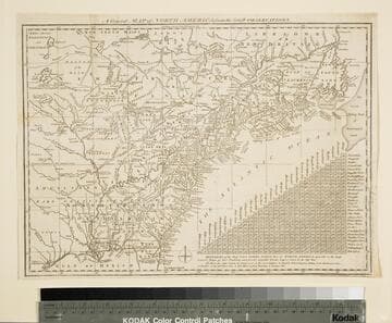
General Map of North America from the Latest Observations
Visual Materials
Kashnor gives date as [1776] RLIN record suggests 1778. Map includes distance chart between 29 American and Canadian cities. Bounds of Hudsons Bay [Co.] shown by Treaty of Utrecht. MS note: 102 (on backing). Prime meridian: London. Relief: pictorial. Projection: Mercator. Printing Process: Copper engraving. Verso Text: MS note: 1776.
105:102 S