Visual Materials
Chart of the Saintes from an Actual Survey

You might also be interested in
Image not available
Chart of West Falkland Island, from an Actual Survey by Lieut. Thos. Edgar of the Royal Navy, in the Years 1786 & 1787
Visual Materials
Submap: Chart of Falkland Islands.. Prime meridian: GM. Relief: hachures. Graphic Scale: Leagues. Projection: Plane. Printing Process: Copper engraving. Other Features: Sub-maps. Verso Text: MS notes: 657 22.
093:657 M
Image not available
Plan of the Island of Fernand de Noronha, from a French Survey, Compared with the Survey made by The Colchester man of war in 1760. Communicated by Mr. Norris of Liverpool
Visual Materials
Vignettes: Five vignettes of views of island.. Prime meridian: London. Relief: hachures. Graphic Scale: Miles. Projection: Plane. Watermark: Shield. Printing Process: Copper engraving. Other Features: Vignettes. Verso Text: MS note: 647.
093:647 M
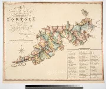
To Isaac Pickering Esqr of Fox Lease Hants this Plan of Tortola From actual Survey by George King is dedicated by His most obedient humble Servant Robt. Wilkinson
Visual Materials
Kashnor notes, "With a list of 104 plantations indicated on plan, with owners names." Pickering held the westernmost point of this island in the British Virgin Islands. Reference table listing owners and parcel numbers. MS note: 843 29. Prime meridian: GM. Relief: hachures. Graphic Scale: Miles, chains. Projection: Plane. Printing Process: Copper engraving. Verso Text: MS note: 843.
093:843 M

Barbadoes, Surveyed by William Mayo, Engraved and Improved by Thomas Jefferys, Geographer to the King
Visual Materials
Vignettes: Two views of island from shipboard.. Prime meridian: London. Relief: hachures. Graphic Scale: Miles, leagues. Projection: Plane. Printing Process: Copper engraving. Other Features: Vignettes. Verso Text: MS note: 747.
093:747 M

Plan of the Havana and its Environs with the several Posts and Attacks, made by the British Forces; under the Command of the Earl of Albemarle and Sr. Geo. Pocock: which was taken 13 Aug: 1762
Visual Materials
Relief: hachures. Graphic Scale: Miles, feet. Projection: Plane. Printing Process: Copper engraving. Verso Text: MS note: 752.
093:752 M

The seat of action between the British and American forces or an authentic plan of the western part of Long Island with the engagement of the 27th. August 1776. between the King's Forces and the Americans: containing also Staten Island, and the environs of Amboy and New York, with the course of Hudsons River, from Courtland the Great Magazine of the American Army, to Sand Hook / from the surveys of Major Holland
Visual Materials
Kashnor notes, "A rare war map." Ms note: 110 (on backing). Submap shows road from Amboy to Philadelphia. Relief: hachures. Graphic Scale: Miles, British. Projection: Plane. Watermark: I V. Printing Process: Copper engraving.
093:110 M