Visual Materials
The seat of action between the British and American forces or an authentic plan of the western part of Long Island with the engagement of the 27th. August 1776. between the King's Forces and the Americans: containing also Staten Island, and the environs of Amboy and New York, with the course of Hudsons River, from Courtland the Great Magazine of the American Army, to Sand Hook / from the surveys of Major Holland

You might also be interested in
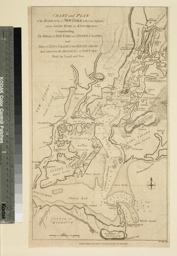
Chart and Plan of the Harbour of New York & the Couny. Adjacent, from Sandy Hook to Kingsbridge, Comprehending the Whole of New York and Staten Islands, and Part of Long Island & the Jersey Shore: And shewing the Defences of New York Both by Land and Sea
Visual Materials
Shows sites of important military engagements. MS note: 119 (on backing). Relief: hachures. Graphic Scale: Miles. Projection: Plane. Watermark: VI. Printing Process: Copper engraving. References: Haskell, D. C. 534; Phillips p.528..
105:119 S

Plan of the Attack against Fort Louis now Fort George, at Point a Pitre on the Island of Gaudaloupe: By a Squadron of his Majesty's Ships of War detached from Commodore Moore, & Commanded by Capt. Wm. Harman, on the 14 FRebruary 1759. Drawn on the Spot by Lieut. Col. Rycaut of the Marines
Visual Materials
Kashnor notes, "somewhat wormed." Submap: Plan of the Harbour of Point a Pitre on the Island of Guadaloupe. MS note: 777 (on backing). Relief: hachures. Graphic Scale: Yards. Projection: Plane. Printing Process: Copper engraving. Other Features: Sub-maps. Verso Text: MS note: 777 (on backing).
093:777 M
Image not available
Map of the Islands of Orleans with the Environs of Quebec
Visual Materials
Kashnor links with 093:328 and dates as ca. 1759. See 105:676 for another copy. MS note: 329 (on backing). Relief: hachures. Graphic Scale: Miles. Projection: Plane. Printing Process: Copper engraving. Verso Text: MS note: 329 (on backing).
093:329 S
Image not available
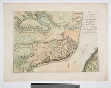
A Map of the Islands of Orleans with the Environs of Quebec
Visual Materials
A duplicate of map 093:329. Kashnor dates as ca. 1760. MS note: 676 (on backing). Relief: hachures. Graphic Scale: Miles. Projection: Plane. Printing Process: Copper engraving.
105:676 S

Plan of the Town of Basse Terre the Capital of Guadaloupe from an Authentic Survey
Visual Materials
Kashnor notes, "Issued shortly after the attack on Basse Terre during the Old French War." MS note: 778 (on backing). Relief: hachures. Graphic Scale: Yards. Projection: Plane. Watermark: P. Printing Process: Copper engraving. Verso Text: MS note: 778 (on backing).
093:778 S
Plan of the City and Environs of Quebec with its Siege and Blockade by the Americans, from the 8th of December 1775 to the 13th of May 1776
Visual Materials
Kashnor notes, "A very fine war plan, in colours, showing where Montgomery made his attack and the emplacement of batteries." A stunning map. Kershaw supplies appeared in information. Relief: hachures. Graphic Scale: Yards. Projection: Plane. Watermark: Crowned fluer-di-lis W F. Printing Process: Copper engraving. References: Kershaw 1041; LC Phillips 1207,1337.. Verso Text: MS note: 120.
093:120 M